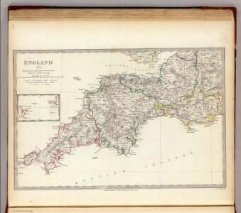
Maps of South West England

England IV.
1 : 765000 Society for the Diffusion of Useful Knowledge (Great Britain)
Carte de la mer d'Ecosse contenant les isles et costes septentrionales et occidentales d'Ecosse et les costes septentrionales d'Irlande
1 : 1200000
Scotiæ tabula
1 Karte : Kupferdruck ; 18 x 27 cm Quad; Nagel Johannes Bussemacher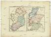
Postkarte von Scotland und Ireland
Irsko, ostrov Stenger, Johann im von Reillyschen Landkarten und Kunstwerke Verschleiss Komptoir
England & Wales, south-western section; Scilly Isles.
1 : 633600 John Bartholomew & Co.
Composite: Lanarkshire.
1 : 82000 Thomson, John
England & Wales SW.
1 : 633600 Stanford, Edward
Watershed map England, Wales 3.
1 : 760320 Letts, Son & Co.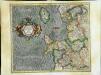
Westmorlandia, Lancastria, Cestria, Caernarvan, Denbigh, Flint, Merionidh, Montgomery, Salopia cum insulis Mania et Anglesey
1 Karte : Kupferdruck ; 34 x 40 cm Mercator; Hondius Henricus Hondius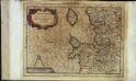
Westmorlandia, Lancastria, Cestria, Caernarvan, Denbigh, Flint, Merionidh, Montgomery, Salopia cum insulis Mania, et Anglesey
1 Karte : Kupferdruck ; 17 x 24 cm Mercator Cloppenburgh
Westmorlandia, Lancastria, Cestria, Caernarvan, Denbigh, Flint, Merionidh, Montgomery, Salopia cum insulis Mania et Anglesey
1 Karte : Kupferdruck ; 34 x 40 cm Mercator; Hondius Jodocus Hondius
Watershed map England, Wales 5.
1 : 760320 Letts, Son & Co.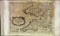
Cornvbia, Devonia, Somersetvs, Dorcestia, Wiltonia, Glocestra Monvmetha, Glamorgan, Caermarden, Penbrok, Cardigan, Radnor, Breknoke, Herefordia, [et] Wigornia
1 Karte : Kupferdruck ; 17 x 24 cm Keere; Mercator Cloppenburgh
Cornvbia, Devonia, Somersetvs, Dorcestria, Wiltonia, Glocestria Monvmetha, Glamorgan, Caermarden, Penbrok, Cardigan, Radnor, Breknoke, Herefordia, [et] Wigornia
1 Karte : Kupferdruck ; 35 x 45 cm Hondius; Mercator Henricus Hondius
Cornvbia, Devonia, Somersetvs, Dorcestria, Wiltonia, Glocestria Monvmetha, Glamorgan, Caermarden, Penbrok, Cardigan, Radnor, Breknoke, Herefordia, [et] Wigornia
1 Karte : Kupferdruck ; 35 x 45 cm Mercator; Hondius Jodocus Hondius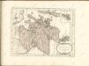

Scotiae Provintiae; Inter Taum Fluvium et Septentrionales oras Angliae. [Karte], in: Novus atlas absolutissimus, Bd. 8, S. 160.
1 Karte aus Atlas Janssonius Offizin
England & Wales NW.
1 : 633600 Stanford, Edward
Scotland.
1 : 760000 Rand McNally and Company

CUMBRIAE TYPUS auctore HVMFREDO LHVYD, Denbigiense Cambrobritanno
This is a map of Wales by Humpfry Lyde, after Ortelius. It forms part of an atlas that belonged to William Cecil Lord Burghley, Elizabeth I’s Secretary of State. Burghley used this atlas to illustrate domestic matters. Lyde, Humpfry
Le royavme d'Escosse
1 Karte : Kupferdruck ; 45 x 59 cm Nolin; Du Tralage; Coronelli; Mondhare; Jean chez Mondhare et Jean rue St. Jean de Beauvais
Royaume d'Escosse
1 Karte : Kupferdruck ; 37 x 51 cm Fer chez l'autheur dans l'isle du Palais sur le quay de l'Orloge a la sphere royale
Le royavme d'Escosse
1 Karte : Kupferdruck ; 45 x 60 cm Nolin; Coronelli chez I. B. Nolin sur le quay de l'Horloge du Palais proche la rue de Harlay a l'enseigne de la place des Victoires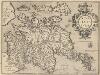
Scotiae Tabula. [Karte], in: Theatrum orbis terrarum, S. 80.
1 Karte aus Atlas Ortelius, Abraham Vrients, Jan Baptista
Cambriae typus
1 : 780000
Charte von England und Wallis, 1
1 Blatt : 62 x 53 cm Walch
Karte von England und Wallis, 1
1 Blatt : 63 x 54 cm Schrämbl