Maps of British Isles
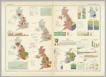
British Isles. Pergamon World Atlas.
Polish Army Topography Service
British Isles.
1 : 2728000 Gray, Ormando Willis
Hydrographical map, British Isles.
1 : 1600000 Stanford, Edward
TABULA NOVISSIMA ACCURATISSIMA REGNORUM ANGLIAE, SCOTIAE HIBERNIAE
1 : 1900000 Anglie Seutter, Matthäus Mattheo Seutter
Tabula novissima accuratissima regnorum Angliae, Scotiae Hiberniae
1 : 1900000 Irsko Seutter, Matthäus M. Seutter
Grossbritannien und Irland

United Kingdom.
1 : 4100000 Darton, William
Britische Inseln
Neuer Handatlas über alle Theile der Erde Kiepert, Heinrich Verlag von Dietrich Reimer
Philips Railway map of the British Isles

Iles Britanniques.
Andriveau-Goujon, J.
Tabula novissima accuratissima regnorum Angliae, Scotiae Hiberniae
1 : 1850000 Irsko Seutter, Matthäus Mattheo Seutter
British Islands.
1 : 2300000 Morse, Jedidiah; Morse, Sidney E. (Sidney Edwards), 1794-1871
[Ethnographic Map of Great Britain and Ireland]
The physical atlas Johnston, Alexander Keith William Blackwood & Sons
British Islands.
1 : 3400000 Greenleaf, Jeremiah
British Islands.
1 : 3484800 Greenleaf, Jeremiah
Iles Britanniques ou Royaume Uni de la Grand Bretagne et la l'Irland.
1 : 3300000 Monin, C.V.
British Empire.
1 : 3200000 Lavoisne, M.
Stereographical map, British Isles.
1 : 1600000 Stanford, Edward
Die Britischen Inseln oder die Vereinigten Königreiche
1 : 1850000 Normanské ostrovy Kiepert, Heinrich Gräf, C. Geographisches Institut
Brittannicae Insule ex Aevi Romani Monumentis. (1826)
1 : 3900000 Tanner, Henry S.

British Isles.
1 : 3651000 Fisher, Richard Swainson
British Isles (Political).
1 : 1900000 Johnston, W. & A.K.
Novissima prae caeteris aliis accuratissima regnorum Angliae, Scotiae Hiberniaeq[ue] tabula
1 : 1850000 Irsko Wit, Frederick de F de Wit
British Islands.
1 : 4000000 Schonberg & Co.
Novissima prae caeteris aliis accuratissima regnorum Angliae, Scotiae, Hiberniae tabula
1 : 1900000 auctore Petri Schenk Amstelodami : Petrus Schenk
Welká Britanie a Iry
1 : 3400000 Irsko Merklas, Václav W. Merklas
British Isles.
1 : 2661120 Letts, Son & Co.
Railway Map of the British Isles.
1 : 2217600 Fullarton, A. & Co.
The British Isles.
1 : 2700000 Society for the Diffusion of Useful Knowledge (Great Britain)
British Islands.
1 : 3484800 Burr, David H., 1803-1875
British Isles, Asia.
Adams, Daniel