Maps of United Kingdom

British Isles. Pergamon World Atlas.
Polish Army Topography Service
Brittischen Inseln.
1 : 10000000 Brudin, J. L.; Stieler, Adolf
Composite: Grossbritannien.
1 : 1500000 Petermann, A.
Philips' Railway Map of the British Isles
1 : 1087000 Edinburgh (Skotsko) George Philip & Son
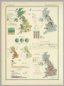
British Isles. Pergamon World Atlas.
Polish Army Topography Service
British Isles.
1 : 2250000 Hall, S. (Sidney)
Industrial map of the British Islands
1 : 1200000 Shetlandy (Skotsko) Hughes, W. George Philip & Son
Comparative Size of Lakes and Islands.
Colton, G. Woolworth
Bretagne Romaine sous Honorius, 400 ans apres Jesus Christ.
1 : 4500000 Houze, Antoine Philippe
Great Britain and Ireland. .
1 : 3380000 Sharpe, J.
Her most excellent majesty queen Victoria this Hydrolographical map of the British Isles
1 : 1600000 Velká Británie Petermann, August Symons, G. J. Edward Stanford
Grande Bretagne, Irlande 1400 a 1603.
1 : 4500000 Houze, Antoine Philippe
Geological map, British Isles.
1 : 1600000 Stanford, Edward
General Carte von Gross Britannien
1 : 2950000 Irsko Mollo, Tranquillo Tranquillo Mollo
Angleterre, Ecosse, Irlande et Man en 1100.
1 : 4500000 Houze, Antoine Philippe
Insulae Britannicae
1 : 3760000 Velká Británie Bonne, Rigobert André
Isles Britanniques
1 : 3770000 Anglie Bonne, Rigobert André
Angleterre, Ecosse & Irlande en 900.
1 : 4500000 Houze, Antoine Philippe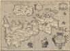
Britannicarum Insularum Typus. [Karte], in: Theatrum orbis terrarum, S. 456.
1 Karte aus Atlas Ortelius, Abraham Vrients, Jan Baptista
Grossbritannien und Ireland
1 : 2200000 Irsko Weiland, Karl Ferdinand Maedel, Carl Jos. Geograph. Institut
Grossbritanien und Irland
Irsko Sotzmann, Daniel Friedrich Kliewer, Heinrich
Magna Britannia et Hibernia
1 : 2400000 Irsko Walch, Johann Dorret, J. J. Walch
Magna Britannia et Hibernia
1 : 2400000 Irsko Walch, Johann Dorret, J. J. Walch
Petit Neptune anglois ou carte marine des côtes d'Angleterre, d'Ecosse et d'Irlande
1 Karte : Kupferdruck ; 65 x 50 cm Bonne; Lattré; Marillier; Berthault chez Lattré graveur rue St. Jacques près la fontaine St. Severin à la ville de Bordeaux
Royaume Uni, Angleterre, Ecosse, et Irlande 1603 a 1839.
1 : 4500000 Houze, Antoine Philippe
Britannia et Hibernia.
1 : 3000000 Strabo
Composite: Carte des Iles Britanniques.
1 : 2600000 Vivien de St Martin, L.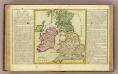
Isles Britanniques.
1 : 3000000 Clouet, J. B. L. (Jean-Baptiste Louis), b. 1730
Bretagne Anglo Saxonne, 600 ans apres Jesus Christ.
1 : 4500000 Houze, Antoine Philippe