Maps of Los Lagos
(Mapa de la Republica de Chile 8)
1 : 11000000 Pissis, Aime, 1812-1889
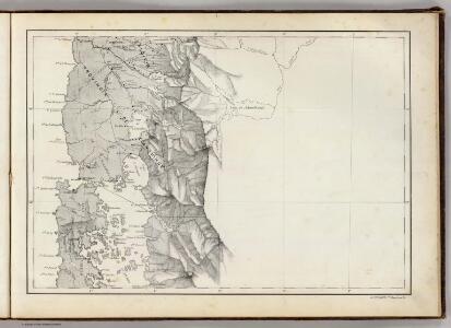
Llanquihue [41°-42° S]
1 : 250000 Comisión Chilena de Límites [Santiago du Chili] : Comision chilena de limites
The channels between Port de Ancud and Port Montt by the Officers of H.M.S. Beagle, 1835
[The channels between Port de Ancud and Port Montt ... by the Officers of H.M.S. Beagle, 1835, etc. (Port Abtao. Port Montt. Entrance of the River Maulin)]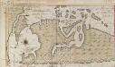
Een haven aen de kust van Chili
Chile Gerard van Keulen
Mapa de la region patagonica entre los grados 41 y 47 sur
1 : 500000 Argentine. Oficina de Límites Internacionales [Buenos Aires ?] :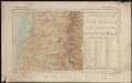
Republica de Chile [39°-41° S]
1 : 500000 (Chili) Oficina de Mensura de Tierras Santiago du Chili : Oficina de Mensura de Tierras
Demarcacion de limites con Chile. Plano general de la sub-comision n°4
1 : 500000 Argentine. Oficina de Límites Internacionales [Buenos Aires ?] :
Nieuwe afteekeningh van Chili geeleegen in de Groodt Zuijt Zee
Chile Gerard van Keulen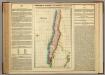
Map Of Chili.
1 : 9757440 Lea, I.
Composite: Mapa de la Republica de Chile (1-8)
1 : 11000000 Pissis, Aime, 1812-1889
Partie, (Chili, la Plata). Amer. Merid. 36.
1 : 1641836 Vandermaelen, Philippe, 1795-1869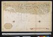
Afteekening van een gedeelte van de kust van Chili in de Zuijd Zee van El Laguia tot C. de la Victoria
Chile Gerard van Keulen
Gobernacion del Neuquen
1 : 1400000 Seelstrang, Arthur Eduard von 1838-1896 Buenos-Aires : J. Ruland
Plano del territorio del Neuquen
1 : 570000 Argentina Oficina cartografica Ludwig
Rio Negro.
1 : 3170000 Paz Soldan, Mariano Felipe, 1821-1886
Partie, la Patagonie. Amer. Merid. 38.
1 : 1641836 Vandermaelen, Philippe, 1795-1869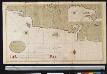
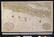
Een gedeelte van de kust van Chili in de Zuijd Zee van Po. IJtata tot El Laguia of van 36 tot 41 graden Breete
Chile Gerard van Keulen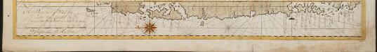
Het Vervolg van de Kust van Chili van de Straat van Magalanus tot 't Eyland La Mocha
Chile Gerard van Keulen
Registro gráfico del territorio del Chubut
1 : 500000 Argentina Oficina cartografica Ludwig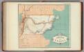
Gobernacion de Chubut.
1 : 3125000 Paz Soldan, Mariano Felipe, 1821-1886
Gobernacion de Neuquen.
1 : 1800000 Paz Soldan, Mariano Felipe, 1821-1886
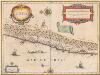
CHILI
[Amsterdam : Joan Blaeu]
Geographisch-statistische und historische Charte von Chile
1 : 3500000 Weimar : Verlag des Geographischen Instituts
Chili [Karte], in: Theatrum orbis terrarum, sive, Atlas novus, Bd. 2, S. 362.
1 Karte aus Atlas Blaeu, Joan Blaeu, Willem Janszoon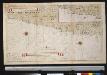
De kusten van Chili
Chile Gerard van Keulen
Patagonia ... South Orkney ... Falkland Islands ... South Georgia Island.
1 : 8236800 Colton, G.W.
Carte de la Patagonie et des Archipels de la Terre de Feu des Malounies et des Còtes Occidentales
1 : 2000000 Description géographique et statistique de la Confédération Argentine Martin de Moussy, Victor Librairie de Firmin Didot frères, fils et Cie
Esquisse de la Patagonie (République Argentine)
1 : 6000000 Paris : Erhard et fils