Maps of Switzerland
Swisserland.
1 : 500000 Pinkerton, John, 1758-1826
Karte von der Schweiz
1 : 44000 Švýcarsko Reilly, Franz Johann Josef von Faden, William Reilly'schen Landkarten und Kunstwerke Verschleis Komptoir
La Svizzera di Keler divisa in 22 cantoni colla relativa popolazione secodo le piu recenti statistiche 1846
Švýcarsko Pierre et Joseph Valardi
Helvetiæ Rhetiæ [et] Valesiæ cum omnibus finitimis regionibus tabula vulgo Schweitzerland
1 Karte : Kupferdruck ; 40 x 51 cm Janssonius apud Joannem Janssonium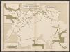
Graphisch-statistischer Atlas der Schweizerischen Normalbahnen
1 : 500000 Leistungen des Betriebsmaterials 1881 Schweizerische Nordostbahn Lithographie Druck & Verlag von Hofer & Burger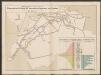
Graphisch-statistischer Atlas der Schweizerischen Normalbahnen
1 : 500000 Ursprüngliche, bis Ende 1881 berechnete Anlagekosten nach Strecken Schweizerische Nordostbahn Lithographie Druck & Verlag von Hofer & Burger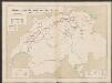
Graphisch-statistischer Atlas der Schweizerischen Normalbahnen
1 : 500000 Historische Entwicklung der Netze 1855 - 1882 Schweizerische Nordostbahn Lithographie Druck & Verlag von Hofer & Burger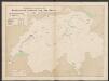
Graphisch-statistischer Atlas der Schweizerischen Normalbahnen
1 : 500000 Historische Entwicklung der Netze 1855 Schweizerische Nordostbahn Lithographie Druck & Verlag von Hofer & Burger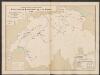
Graphisch-statistischer Atlas der Schweizerischen Normalbahnen
1 : 500000 Historische Entwicklung der Netze 1865 Schweizerische Nordostbahn Lithographie Druck & Verlag von Hofer & Burger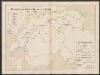
Graphisch-statistischer Atlas der Schweizerischen Normalbahnen
1 : 500000 Historische Entwicklung der Netze 1881 - 1882 Schweizerische Nordostbahn Lithographie Druck & Verlag von Hofer & Burger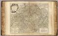
Suisses.
1 : 540000 Robert de Vaugondy, Gilles, 1688-1766
Karte der Militärkreise der Schweiz
Vorderseite: Karte; Rückseite: Verordnung betreffend die Territorialeinteilung und die Nummerierung der Truppeneinheiten sowie der zusammengesetzten Truppenkörper. Mit Legenden. Ausgangskarte: Zweite Kellersche Reisekarte der Schweiz. Verlag: Heinrich Keller's geographischer Verlag, in Zürich (mit Bewilligung des Eidgenössischen Militärdepartements) Ausgangskarte Zeichnung: Keller, Heinrich (1778-1862), Kartograf, Panoramenzeichner und Verleger, von Zürich Ausgangskarte Stich: Scheuermann, Johann Jakob, andere Schreibweise: Scheurmann, (1771-1844), Kupferstecher, von Zofingen AG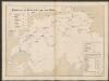
Graphisch-statistischer Atlas der Schweizerischen Normalbahnen
1 : 500000 Historische Entwicklung der Netze 1875 Schweizerische Nordostbahn Lithographie Druck & Verlag von Hofer & Burger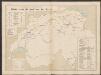
Graphisch-statistischer Atlas der Schweizerischen Normalbahnen
1 : 500000 Historische Entwicklung der Netze 1880 Schweizerische Nordostbahn Lithographie Druck & Verlag von Hofer & Burger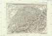
Carte generale de la Suisse suivant ses nouvelles divisions, qui conprennent les ci-devant 13 cantons, leurs alliés et sujets, et forment actuellement la republique Helvetique une et indivisible
1 : 500000 Švýcarsko Mechel, Christian von Chretien de Mechel
Carte générale de la Suisse suivant ses nouvelles divisions, qui comprennent les ci-devant XIII. cantons, leurs alliés et sujets, et forment actuellement la République Helvétique une et indivisible
1 : 510000 Švýcarsko Mechel, Christian von Chretien de Mechel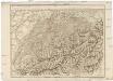
Carte generale de la Suisse suivant ses nouvelles divisions, qui comprennent les ci-devant XIII. cantons, leurs alliés et sujets, et forment actuellement la Republique Helvetique une et indivisible
Švýcarsko Mechel, Christian von Ludvík Chretien de Mechel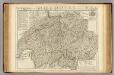
Suisse ou sont les Cantons.
1 : 514000 Merveilleux, David Francois de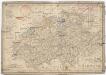
Die Schweiz
1 : 1590000 Švýcarsko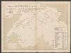
Graphisch-statistischer Atlas der Schweizerischen Normalbahnen
1 : 500000 Historische Entwicklung der Netze 1860 Schweizerische Nordostbahn Lithographie Druck & Verlag von Hofer & Burger
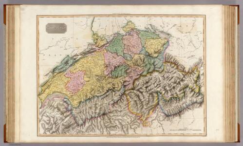
Switzerland.
1 : 1280000 Mitchell, Samuel Augustus
Charte von Helvetien
1 : 847000 Švýcarsko Kipferling, Karl Joseph J. Riedl's Kunsthandlung
Switzerland.
1 : 1050000 Schonberg & Co.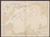
Graphisch-statistischer Atlas der Schweizerischen Normalbahnen
1 : 500000 Historische Entwicklung der Netze 1870 Schweizerische Nordostbahn Lithographie Druck & Verlag von Hofer & Burger
Suisse
1 : 2500000 1 Karte by Rt. Morden [printed for Robert Morden and Thomas Cockerill?], [London]
Telegraphenkarte der schweizerischen Eisenbahnen
1 : 400000 [s.n.]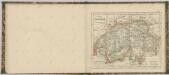
Touristenkarte der Schweiz
1 : 900000 Interlaken (Švýcarsko) Kümmerly & Frey
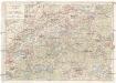
[Keller's zweyte Reisekarte der Schweiz]
Keller, Heinrich Keller