Maps of Bronx County
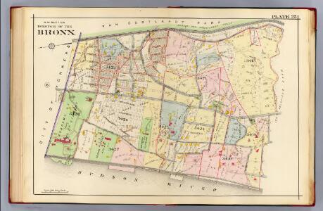
25. N.W. Bronx.
1 : 3600 Kiser, Ellis; Mueller, A. H.
Plate 79, Part of Section 13, Borough of the Bronx. [Bounded by W. W. 250th Street, Broadway, Mosholu Avenue, Post Road, Farraday Avenue, Sylvan Avenue, W. 253rd Street, Fieldston Road, Mosholu Avenue.]
from Atlas of borough of the Bronx, Sections 9 10 11 12 & 13 : from actual surveys and official plans / G.W. Bromley and Co.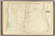
37 ward 24.
1 : 2400 Bromley, George Washington; Bromley, Walter Scott; G.W. Bromley & Co.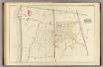
38 ward 24.
1 : 2400 Bromley, George Washington; Bromley, Walter Scott; G.W. Bromley & Co.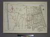
Plate 80, Part of Section 13, Borough of the Bronx. [Bounded by Palisade Avenue, W. 261st Street, Riverdale Avenue, W. 263rd Street, Broadway, Mosholu Avenue, Post Road, Iselin Avenue, Sylvan Avenue, W. 256th Street, Fieldston Road and Mosholu Avenue.]
from Atlas of borough of the Bronx, Sections 9 10 11 12 & 13 : from actual surveys and official plans / G.W. Bromley and Co.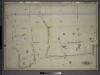
Atlas of the borough of the Bronx, city of New York : based upon official plans and maps on file in the various city offices; supplemented by careful field measurements and personal observations, by and under the supervision of Hugo Ullitz.
from Atlas of the borough of the Bronx, city of New York : based upon official plans and maps on file in the various city offices; supplemented by careful field measurements and personal observations, by and under the supervision of Hugo Ullitz.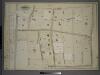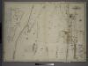
Manhattan, V. 12, Plate No. 45 [Map bounded by Independence Ave., Hudson River]
From Atlas 128. Vol. 12, 1900.
Manhattan, V. 12, Plate No. 46 [Map bounded by W. 256th St., W. 250th St., Independence Ave.]
From Atlas 128. Vol. 12, 1900.
Manhattan, V. 12, Plate No. 47 [Map bounded by Independence Ave., Hudson River]
From Atlas 128. Vol. 12, 1900.
Manhattan, V. 12, Plate No. 49 [Map bounded by W. 260th St., Fieldston Rd., W. 255th St., Riverdale Ave.]
From Atlas 128. Vol. 12, 1900.
Manhattan, V. 12, Plate No. 48 [Map bounded by Arlington Ave., Riverdale Ave., W. 256th St., Independence Ave.]
From Atlas 128. Vol. 12, 1900.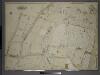
Atlas of the borough of the Bronx, city of New York : based upon official plans and maps on file in the various city offices; supplemented by careful field measurements and personal observations, by and under the supervision of Hugo Ullitz.
from Atlas of the borough of the Bronx, city of New York : based upon official plans and maps on file in the various city offices; supplemented by careful field measurements and personal observations, by and under the supervision of Hugo Ullitz.
Manhattan, V. 12, Plate No. 43 [Map bounded by W. 255th St., Fieldston Rd., W. 250th St., Avenue Von Humboldt]
From Atlas 128. Vol. 12, 1900.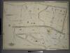
Atlas of the borough of the Bronx, city of New York : based upon official plans and maps on file in the various city offices; supplemented by careful field measurements and personal observations, by and under the supervision of Hugo Ullitz.
from Atlas of the borough of the Bronx, city of New York : based upon official plans and maps on file in the various city offices; supplemented by careful field measurements and personal observations, by and under the supervision of Hugo Ullitz.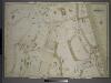
Manhattan, V. 12, Plate No. 44 [Map bounded by W. 254th St., Broadway, W. 250th St.]
From Atlas 128. Vol. 12, 1900.
Manhattan, V. 12, Plate No. 40 [Map bounded by W. 250th St., Arlington Ave., Hudson River]
From Atlas 128. Vol. 12, 1900.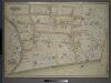
Atlas of the borough of the Bronx, city of New York : based upon official plans and maps on file in the various city offices; supplemented by careful field measurements and personal observations, by and under the supervision of Hugo Ullitz.
from Atlas of the borough of the Bronx, city of New York : based upon official plans and maps on file in the various city offices; supplemented by careful field measurements and personal observations, by and under the supervision of Hugo Ullitz.
Manhattan, V. 12, Plate No. 41 [Map bounded by W. 250th St., Leibnitz Ave., Arlington Ave.]
From Atlas 128. Vol. 12, 1900.
Manhattan, V. 12, Plate No. 50 [Map bounded by W. 259th St., Broadway, W. 254th St., Fieldston Rd.]
From Atlas 128. Vol. 12, 1900.
Manhattan, V. 12, Plate No. 51 [Map bounded by W. 262nd St., Fieldston Rd., W. 260th St., Riverdale Ave.]
From Atlas 128. Vol. 12, 1900.
Manhattan, V. 12, Plate No. 42 [Map bounded by W. 250th St., Tibbett Ave., W. 244th St.]
From Atlas 128. Vol. 12, 1900.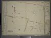
Atlas of the borough of the Bronx, city of New York : based upon official plans and maps on file in the various city offices; supplemented by careful field measurements and personal observations, by and under the supervision of Hugo Ullitz.
from Atlas of the borough of the Bronx, city of New York : based upon official plans and maps on file in the various city offices; supplemented by careful field measurements and personal observations, by and under the supervision of Hugo Ullitz.
Manhattan, V. 12, Plate No. 52 [Map bounded by W. 262nd St., Broadway, W. 259th St., Fieldston Rd.]
From Atlas 128. Vol. 12, 1900.
Manhattan, V. 12, Plate No. 53 [Map bounded by Hudson River, Riverdale Ave., Arlington Ave.]
From Atlas 128. Vol. 12, 1900.
Manhattan, V. 12, Plate No. 36 [Map bounded by Broadway, W. 244th St., Waldo Ave.]
From Atlas 128. Vol. 12, 1900.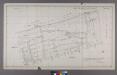
Section 26 of Final Maps and Profiles, of the 23rd & 24th Wards.
from Maps or plans and profiles, with field notes and explanatory remarks, showing the location, width, grades, and class of streets, roads, avenues, public squares and places, located and laid out by the Commissioner of Street Improvements of the 23rd and 24th wards of the city of New York : under authority of Chapter 545 of the laws of 1890.