Maps of Cumberland Plat.

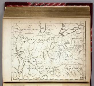
Map of the Back Settlements.
1 : 6336000 Morse, Jedidiah
The Western Parts of Virginia, Pennsylvania, Maryland and North Carolina.
1 : 1140480 Hutchins, Thomas
200-201. United States of America, North East Central. The World Atlas.
1 : 2500000 USSR (Union of Soviet Socialist Republics).
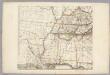
Country drained by the Mississippi Eastern Section.
1 : 4752000 Long, Stephen H.
Die Staaten von Missouri, Illinois, Indiana, Ohio, Kentucky und Tennessee
Ind., Ill., Mo., Ohio, Ky, Tenn.
1 : 2100000 Asher, Adams & Higgins; Higgins & Ryan
Ohio, Indiana, Kentucky, and Tennessee.
1 : 3651000 Fisher, Richard Swainson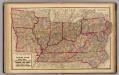
Delaware, Illinois, Indiana, Iowa ... North Carolina ... Tennessee, Virginia.
1 : 3000000 Lloyd, H.H.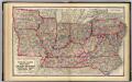
Delaware, Illinois, Indiana, Iowa ... North Carolina ... Tennessee, Virginia.
1 : 3000000 Walling, H. F.
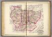
County map of the State of Illinois ; Plan of Chicago [inset].
from New general atlas.
151. Centers farm, agricultural products, population, manufactures.
1 : 7000000 Gannett, Henry, 1846-1914; United States. Census Office
126. Centers of population, farms, agricultural products, manufactures 1790-1900.
1 : 7000000 Gannett, Henry, 1846-1914; United States. Census Office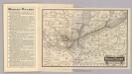
Map Wabash Railway.
1 : 6623200 Wabash Railway Company
Western States.
1 : 6400000 Adams, Daniel
Western States, United States.
Goodrich, S.G.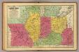
Western States.
1 : 3200000 Mitchell, Samuel Augustus
Western states, territories.
1 : 6400000 Grigg, John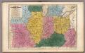
Map of the Western States.
1 : 3200000 Mitchell, Samuel Augustus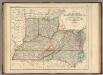
States Of Delaware, Maryland, Virginia (with the District of Columbia) North Carolina, Ohio, Kentucky, Tennessee, And Indiana.
1 : 3453120 Rogers, Henry Darwin
County map of Ohio and Indiana.
from New general atlas.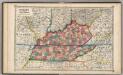
Kentucky and Tennessee,
1 : 2150000 Schonberg & Co.
Ohio, Indiana, Illinois, Michigan.
1 : 2063000 Finley, Anthony
Shell Sectional Map No. 4 - East Central States.
1 : 1710720 Shell Oil Company
County map of Kentucky and Tennessee.
from Mitchell's new general atlas, containing maps of the various countries of the world, plans of cities, etc., embraced in fifty-three quarto maps., forming a series of eighty four maps and plans, together with valuable statistical tables.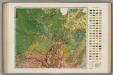
Soil Map of the United States, Section 7. Atlas of American Agriculture.
1 : 2500000 Marbut, Curtis F.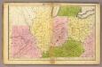
Western States.
1 : 3000000 Huntington, Francis Junius, 1802-1878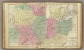
Western U.S.
1 : 3000000 Cornell, S. S. (Sarah S.)
N. W. Territory.
1 : 8236800 Carey, Mathew
Army of the Cumberland.
1 : 7800000 National Tribune Co.