Maps of Bronx County

Plaines Blanches et Armees Americaine et Britannique, 12 Octobre1776.
1 : 130000 Marshall, John
Country from Frog's Point to Croton River shewing the American and British Armies 1776.
1 : 120000 Marshall, John
Colton's driving & wheeling map of the country twenty five miles north of the city of New York.
1 : 73000 G.W. & C.B. Colton & Co.
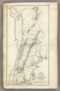
A plan of the country from Frogspoint to Croton River shewing the positions of the American and British armies from the 12th of October 1776 until the engagement on the White Plains on the 28th
1 : 128400 Lewis, Samuel Wayne, Caleb Parry
Westchester, Double Page Plate [Map of Westchester County, Irvington, Tarry Town to Sing Sing, East to State Line] / prepared under the direction of Joseph R. Bien, from general surveys and official records.
From Atlas of Westchester County, New York
Tarrytown
1 : 62500
Tarrytown
1 : 62500
Tarrytown
1 : 62500
Tarrytown
1 : 62500
Tarrytown
1 : 62500
Tarrytown
1 : 62500
Tarrytown
1 : 62500
Tarrytown
1 : 62500
Tarrytown
1 : 62500
Tarrytown
1 : 62500
Westchester, Double Page Plate No. 13 [Map of Towns of Scarsdale, New Rochelle, and Mamaroneck] / prepared under the direction of Joseph R. Bien, from general surveys and official records.
From Atlas of Westchester County, New York
Harlem
1 : 62500
Harlem
1 : 62500
Harlem
1 : 62500
Harlem
1 : 62500
Harlem
1 : 62500
Harlem
1 : 62500
Harlem
1 : 62500
Harlem
1 : 62500
Harlem
1 : 62500
Harlem
1 : 62500
Harlem
1 : 62500
Harlem
1 : 62500
Harlem
1 : 62500
Harlem
1 : 62500
Harlem
1 : 62500
Harlem
1 : 62500
Harlem
1 : 62500
Harlem
1 : 62500
Harlem
1 : 62500
Harlem
1 : 62500