Maps of Netherlands
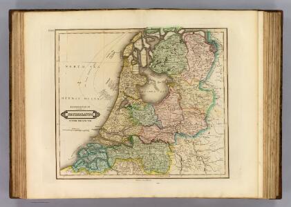
Netherlands.
1 : 690000 Lizars, Daniel
Holland (Netherlands).
1 : 1270000 Higgins, W.M.
De Zeven Verenigde Nederlanden
1 : 800000 afgebeeld door W.A. Bachiene J. van Jagen sculp. Te Amsterdam : bij D. Onder de Linden

Nieuwe kaart van het Koningrijk Holland verdeeld in X Departementen.
1 : 570000 Te Amsterdam : bij Mortier Covens en Zoon
Die vereinigten Niederlande
Nizozemsko Sotzmann, Daniel Friedrich Franz
Belgii faederati nova descriptio
1 : 700000 auctore Jodoco Hondio. T'Amsterdam : by Clemendt de Jonghe exc.
Carte nouvelle des Provinces Unies des Pais Bas dressée suivant les dernières observations = Nieuwe kaart van de VII Provintien naar de nieuwste waarneemingen.
1 : 580000 Te Amsterdam : bij I. Covens & Zoon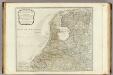
The Seven United Provinces.
1 : 560000 Kitchin, Thomas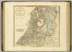
United Provinces.
1 : 590000 Cary, John, ca. 1754-1835
Belgium Foederatum auctius et emendatius
1 : 780000 Mollova mapová sbírka Seutter, Matthäus Lotter, Tobias Conrad Seutter, Matthäus
Les Provinces Unies ou la Partie Septentrionale des Pays Bas
1 : 780000 Mollova mapová sbírka Coronelli, Vincenzo Maria Loon, Herman van Nolin, Jean Baptist François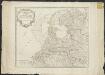
Les Provinces-Unies des Pays-Bas que comprennent le duché de Gueldre, les comtés de Hollande, de Zelande, de Zutphen, les Seigneuries d'Utrecht, d'Ouest-Frise, d'Ower-Issel et de Groningue
1 : 600000 par le Sr. Robert [gravé par] Haussard. [Paris] : [Robert]
Nieuwe kaart van de VII Vereenigde Provintien, volgens de nieuwste waarneemingen opgemaakt]
1 : 1650000 [S.l.] : [s.n.]
Holland.
1 : 1300000 Finley, Anthony
Holland.
1 : 1280000 Tanner, Henry S.
Des Burgundischen Creisses Nordlicher Theil oder Vereinigte Niederlande
1 : 2200000 Mollova mapová sbírka Weigel, Christoph Weigel, Christoph I. - dědici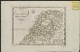
Nieuwe algemeene kaart der Bataafsche Republiek : verdeeld in 94 districten bevattende ieder nagenoeg 20000 zielen
1 : 1400000 C. Covens delin. C. van Baarsel sculps. Te Amsterdam : bij Mortier Covens & Zoon
Algemeene kaarte der Nederlandsche Republiek, verdeeld naar derzelver kerkelyk bestuur
door W.A. Bachiene ... J. van Jagen sculps. 1767. Amsterdam : bij D. onder de Linden
Karte von der Republik der vereinigten Niederlande
1 : 470000 Nizozemsko Reilly, Franz Johann Josef von Stöber, Joseph Franz Joh. Jos. von Reilly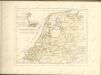
Seat of war United Provinces.
1 : 575000 Robert Laurie & James Whittle
Belgii Pars Septentrionalis communi nomine Vulgo Hollandia nuncupata
1 : 650000 Mollova mapová sbírka Homann, Johann Baptist Homann, Johann Baptista - dědici
Belgium Foederatum
1 : 620000 Mollova mapová sbírka Visscher, Nicolaes Schenk, Peter II
Belgica Foederata complectens septem Provincias,
1 : 610000 Mollova mapová sbírka Valk, Gerhard Valck, Gerard
Nieuwe kaart der Vereenigde Nederlanden.
1 : 1000000 Te Amsterdam : by Isaak Tirion
Belgica Foederata
1 : 610000 Mollova mapová sbírka Lotter, Tobias Conrad Lotter, Tobias Conrad
Belgium foederatum
1 Karte : Kupferdruck ; 47 x 55 cm Seutter Matthäus Seutter
Nieuwe kaart der Vereenigde Nederlanden
1 : 900000 Amsterdam : by Isaak Tirion
Belgium foederatum
1 : 625000 Maastricht (Nizozemsko) Visscher, Nicolaes Jansz. Schenk, Pieter P. Schenk iunior
Belgium foederatum
1 : 625000 Maastricht (Nizozemsko) Visscher, Nicolaes Jansz. par Nicolaum Visscher