Maps of Balkan Pen.
Turkey in Europe.
1 : 2533000 Johnston, Alexander Keith
Turkey in Europe.
1 : 2533000 Johnston, Alexander Keith
Turkey in Europe.
1 : 2533000 Johnston, W. & A.K.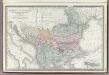
Turkey in Europe.
1 : 3300000 Rand McNally and Company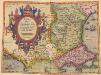
Romaniae, (quae olim Thracia dicta) Vicinarumque Regionum, Uti Bulgariae, Walachiae, Syrfiae, Etc. Descriptio. [Karte], in: Theatrum orbis terrarum, S. 283.
1 Karte aus Atlas Ortelius, Abraham
Map of the Balkan States
Balkanhalbinsel
Schul-Atlas für die alte Erdbeschreibung : zur allgemeinen Schul-encyclopädie gehörig
J. H. Campe Zusammensetzung und Zeichnung von [...] Dufour, unter Leitung von Heusinger ; gestochen von Frentzel. Braunschweig : Schulbuchhandlung
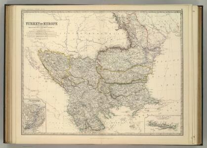
Turkey in Europe.
1 : 4000000 Colton, G.W.
Turkey in Europe.
1 : 3000000 Colton, G.W.
[Ost-Europa in 6 Blättern, Blatt 5]
Handatlas über alle Theile der Erde und über das Weltgebäude Stieler, Adolf Justus Perthes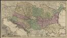
Novissima tabula regni Hungariae et regionum quondam ei unitarum ut Transilvaniae, Valachiae, Moldaviae, Serviae, Romaniae, Bulgariae, Bessarabiae, Croatiae, Bosniae, Dalmatiae, Slavoniae, Morlachiae et reipublicae Ragusanae : accedit pars magna dominii Veneti [...]
1 : 2000000 auctore Reinier & Josua Ottens geographe Amstelodamensi J. Keyser sculpsit Te Amsterdam : by Reinier & Iosua Ottens [...]
Turkey in Europe.
1 : 4000000 Colton, G.W.
[Ost-Europa in 6 Blättern, Enthaltend: Norwegen, Schweden, Russland, Kaukasien und die Türkei, Blatt 5]
Hand-Atlas über alle Theile der Erde und über das Weltgebäude Stieler, Adolf Justus Perthes
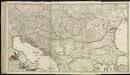
Ost-Europa, No. 5: Sud-West-Russland & die Turkei.
1 : 3700000 Petermann, A.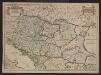
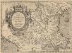
Le Royaume de Hongrie et les estats qui en esté sujets et qui sont presentement la partie septentrionale de la Turquie en Europe. Tiré des memoires les plus nouveaux
1 : 2100000 Ungarn, Südosteuropa Sanson, Guillaume
Hungariae ampliori significatu...
Romaniae, (quae olim Thracia dicta) Vicinarumque Regionum, Uti Bulgariae, Walachiae, Syrfiae, Etc. Descriptio. [Karte], in: Theatrum orbis terrarum, S. 378.
1 Karte aus Atlas Ortelius, Abraham Vrients, Jan Baptista
[79][79]Regni Hungariae, ..., uit: Atlas sive Descriptio terrarum orbis
Annotatie: Gedigitaliseerde versie. Amsterdam. Heiloo : Picturae (vervaardiger), 2015. tiff-bestand. Gedigitaliseerd: 07-01-2015; Origineel: Universiteitsbibliotheek Vrije Universiteit (XL.05127.-) ; Netherlands; Titelpagina ontbreekt Wit, Frederik de Amsterdam : Frederick de Wit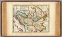
The north part of Turkey in Europe, Slavonia &c.
1 : 5500000 Moll, Herman, d. 1732
Professor W. Liebenow's Kriegskarte der Balkanstaaten
1 : 1250000 balkánské země Liebenow, Wilhelm Gea Verlag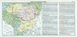
Nr. 17. Bulgarien und die Nationen des Balkans
Balkanhalbinsel, Bulgarien
Turkey In Europe.
1 : 4942080 Tallis, J. & F.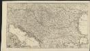
Novissima tabula regni Hungariae et regionum quondam ei unitarum ut Transilvaniae, Valachiae, Moldaviae, Serviae, Romaniae, Bulgariae, Bessarabiae, Croatiae, Bosniae, Dalmatiae, Slavoniae, Morlachiae et reipublicae Ragusanae : accedit pars magna dominii Veneti [...]
1 : 2000000 auctore Reinier & Josua Ottens geographe Amstelodamensi J. Keyser sculpsit Te Amsterdam : by Reinier & Iosua Ottens [...]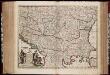
Nova totius Hungariae, Transilvaniae, Serviae, Romaniae, Bulgariae, Walachiae, Moldaviae, Sclavoniae, Croatiae, Bosniae, Dalmatiae, maximaeq[ue] partis Danubii fluminis, descriptio / emendata a F. de Wit
1 : 2600000 Annotatie: Tekst impressum in het Nederlands; Rechtsboven: 21; Kaart toont Hongarije, omliggende landen en een belangrijk deel van de loop van de Donau; Origineel is Blad 129 in atlas factice; Annotatie geografische gegevens: Schaalstok linksonder cartouche: Milliaria Germanica communia 15 uni gradui = Gemeene Duytsche Mylen van 15 in een graedt Frederick de Wit 1630-1706 Amsterdam : gedruckt by Frederick de Wit inde Kalverstraet by den Dam inde Witte Pascaert
Charte vom Türkischen Reiche in Europa / nach den neuesten astronomischen Ortsbestimmungen entworfe
1 : 3500000 1 Karte : Kupferdruck ; 46 x 45 cm Reinecke, Johann Matthias Christoph Verlag des Geogr. Instituts
Nona Europe Tabula [Iazyges Metanastes, Datia, Misia Infer. Misia Superior, Dardania, Tracia] [Karte], in: Claudii Ptolemei viri Alexandrini mathematice discipline philosophi doctissimi geographie opus [...], S. 175.
1 Karte aus Atlas Waldseemüller, Martin [und Ptolemaeus, Claudius] Übelin, Georg
Die Transhumanz der dakorumänischen, aromunischen, meglenorumänischen und istrorumänischen Hirten
Balkanhalbinsel Transhumanz, Walachen Willing, P.