Maps of Mexico

Mexico, Guatimala.
1 : 20500000 Grigg, John
Mexico, Guatimala.
1 : 9500000 Hall, S. (Sidney)
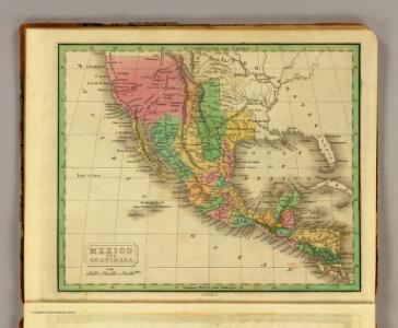
Mexico & Guatemala.
1 : 11800000 Mitchell, Samuel Augustus
Mexico & Guatemala.
1 : 12000000 Tanner, Henry S.
Mexico & Guatemala.
1 : 12000000 Tanner, Henry S.
Mexique.
1 : 8900000 Lapie, M. (Pierre), 1779-1850
Mexico, Guatamala.
1 : 37500000 Fenner, Rest.
Mexique, Republique de l'Amerique Centrale, Sud-Ouest Etats-Unis.
1 : 9200000 Levasseur, E.
Carte Generale du Mexique et des Provinces-unis de l'Amerique Centrale.
1 : 15500000 Vivien de St Martin, L.
Mexico, Mittel-America, Texas.
1 : 12300000 Flemming, Carl
Etats-Unis Mexicains, Texas, Amerique Centrale.
1 : 9300000 Picquet, C.

Mexico, Texas und Californien
1 : 6000000 bearb. und gezeichnet von H. Kiepert Situation und Schrift gestochen von K. Mädel ; Terrain von C. Jungmann Weimar : Verlag des Geographischen Institus
Spanish Dominions in North America.
1 : 19000000 Arrowsmith, Aaron; Lewis, Samuel
Spanish dominions in North America.
1 : 19000000 Arrowsmith, Aaron; Lewis, Samuel
Mexico und Centro-America
Hand-Atlas über alle Theile der Erde nach dem neuesten Zustande und über das Weltgebäude Stieler, Adolf bei Justus Perthes
Central America and Yucatan (Mexico).
from The cerographic atlas of the United States. By Sidney E. Morse, A.M., and Samuel Breese, A.M.
Mexico, Guatemala, W.I., North America.
Goodrich, S.G.
Mexico und Centro-America
Stieler's Hand-Atlas Stieler, Adolf bei Justus Perthes
Mexique, Nlle. Mexique, Californie.
1 : 13300000 Bonne, Rigobert, 1727-1794
United States ... Texas ... Mexico and Guatimala.
1 : 11404800 Mitchell, Samuel Augustus
Map of the United States and Texas ... Mexico and Guatimala.
1 : 11404800 Mitchell, Samuel Augustus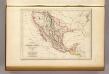
Etats-Unis du Mexique, 1835.
1 : 17000000 Malte-Brun, Conrad, 1775-1826
Mexico und Centro-America
1 : 14000000 nach den besten Hülfsmitteln in Mercators Projection entworfen und gezeichnet vom Pr. L[t]. v. Stülpnagel [...] in Mercators Projection Gotha : Perthes
Washington Map of the United States.
1 : 13000000 Taintor, S. & Co.
Map of the United States and Mexico
1 : 6000000 Johnson & Browning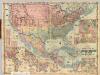
Colton's Railroad and Military Map, United States.
1 : 6500000 Colton, G.W & C.B.
Mexico und die Republiken von Central -America
1 : 6000000 Mexiko Gräf, C. Eyb, O. von Geographisches Institut
Washington Map of the United States.
1 : 13000000 Taintor, S. & Co.