Maps of Netherlands
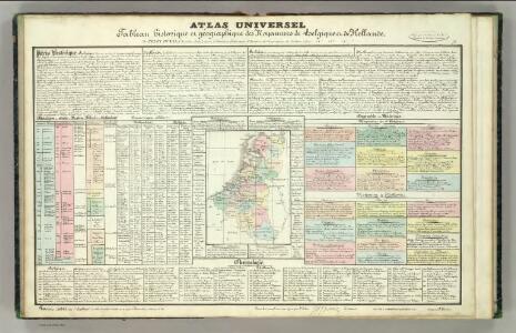
Tableau l'historie des Royaumes de Belgique et de Hollande.
1 : 3200000 Duval, Henri
Nieuwe kaart van het Koningryk der Nederlanden en het Groot-hertogdom Luxemburg
1 : 600000 Belgie Weygand, F. J. Baarsel, Cornelis van
The Kingdom of the Netherlands
1 : 1500000 engraved by J. & C. Walker. London : Baldwin & Cradock
Niederlande, Belgien, Luxemburg
Hand-Atlas über alle Theile der Erde nach dem neuesten Zustande und über das Weltgebäude Stieler, Adolf bei Justus Perthes
[Niederlande, Belgien, Luxemburg]
Hand-Atlas über alle Theile der Erde nach dem neuesten Zustande und über das Weltgebäude Stieler, Adolf bei Justus Perthes
Holland and Belgium.
1 : 1330560 Colton, G.W.
44. Belgio e Olanda.
1 : 1500000 Touring club italiano
Neueste Karte von Holland, Belgien und Luxemburg
Grosser Hand-Atlas über alle Theile der Erde in 170 Karten Meyer, J. Verlag des Bibliographischen Instituts
Niederlande und Belgien
Handatlas über alle Theile der Erde und über das Weltgebäude Stieler, Adolf Justus Perthes
Niederlande Und Belgien.
1 : 1110000 Vogel, C.
Das Koenigreich der Niederlande nebst dem Grossherzogthume Luxemburg
1 : 925000 Belgie Weiland, Karl Ferdinand Geographisches Institut
Das Königreich der Niederlande, das Königreich Belgien und das Groszherzogthum Luxemburg
1 : 950000 entworfen und gezeichnet von C.F. Weiland. Weimar : im Verlage des Geogr. Instituts
Nieuwe kaart van het Koningrijk der Nederlanden en het Groot-Hertogdom Luxemburg, benevens geheel België : verdeeld in provincien volgens de jongste bepalingen, verrijkt met de post & andere groote wegen
1 : 1000000 zamengest. & gegraveerd door W.C. van Baarsel. Te Zalt-Bommel : bij Joh. Noman en Zoon
Les sept provinces unies des Pay-Bas, ou la Hollande, avec les Pay-Bas Autrichiens
1 : 1480000 Nizozemsko Bonne, Rigobert André
Niederlande und Belgien
Hand-Atlas über alle Theile der Erde und über das Weltgebäude Stieler, Adolf Justus Perthes
Holland and Belgium.
1 : 1290000 Colton, G.W.
Belgique, Hollande, Limbourg, Luxembourg.
1 : 1000000 Picquet, C.
Holland and Belgium.
1 : 4000000 Colton, G.W.
Netherlands, Belgium.
1 : 1170000 Society for the Diffusion of Useful Knowledge (Great Britain)
Belgium and the Netherlands
1 : 789237 Johnston, Alexander Keith
Netherlands.
1 : 1237000 Teesdale, Henry
Belgium, Netherlands.
1 : 1140480 Letts, Son & Co.
Belgium and the Netherlands
1 : 789237 Johnston, Alexander Keith
Holland and Belgium.
1 : 1290000 Colton, G.W.
Holland And Belgium.
1 : 1187000 Johnson, A.J.
Království Hollandské (Nizozemsko), Království Belgické
Belgie Hynek Fuchs
Belgique et de Hollande, 1812.
1 : 3500000 Malte-Brun, Conrad, 1775-1826
Belgium and the Netherlands
1 : 789237 Johnston, W. & A.K.
Pays-Bas, Belgique, Luxembourg.
1 : 1000000 Levasseur, E.