Maps of Piedmont

Principal cities U.S.
Cornell, S. S. (Sarah S.)
Venango railroad and its connections, air line from New York to Cleveland, Toledo & Chicago
1 : 2000000 J.H. Bufford's Lith.
A Map of the United States of America, 1830.
from Whole
Bacon's steel plate map of the American states north &south, showing the railways, forts, and fortifications

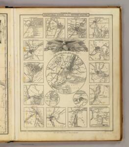
Southern provinces of the United States.
from Charts and maps
A Map of the British American plantations, extending from Boston in New England to Georgia, including all the back settlements in the respective provinces, as far as the Mississipi
1 : 6350000
Map of the roads, canals and steam boat routes of the United States: with the distances from place to place carefully noticed ... / designed for the use of travellers by H.S. Tanner.
from Whole Henry S. Tanner,
Phelps's national map of the United States: a travellers guide: embracing the principal rail roads, canals, steam boat & stage routes, throughout the union / drawn & engraved by J.M. Atwood, New York; portraits & st. arms engd. by Wm. D. Smith.
from Whole J. M. Atwood; Phelps; William D. Smith,
Map of the United States exhibiting the post-roads, the situations, connections & distances of the post-offices, stage roads, counties, ports of entry and delivery for foreign vessels, and the principal rivers

Map of the United States of America.
1 : 5800000 Melish, John
United States.
1 : 8200000 Woodbridge, William C.
Partie de l'Amerique septentrionale, qui comprend le cours de l'Ohio, la Nlle. Angleterre, la Nlle. York, le New Jersey, la Pensylvanie, le Maryland, la Virginie, la Caroline / par le Sr. Robert de Vaugondy, géographe; Groux.
from John H. Levine Collection Robert de Vaugondy,
Map of the United States of America / Gridley, sc.
from Whole Gridley,
Map of the United States of America / J. Melish, del.; H.S. Tanner, sc.
from Whole John Melish; Henry S. Tanner,
Map of the United States.
1 : 6750000 Scott, Joseph
Map of the Seat of Civil War in America, October, 1862
Map of the Seat of Civil War in America, October, 1862. In this map the enlarged segment detailing recent battles focuses on the area along the border of the Union and Confederacy between Maryland and Virginia, particularly from the Chesapeake Bay and Potomac River. Near the top of the enlarged portion, Sharpsburg is labelled, site of the Battle of Antietam in September 1862. Bull Run/Manassas is also marked, along with Fairfax Court House and Centreville, sights that were captured in photographs published by Alexander Gardner. Davies & Co.
Map Of The Seat Of Civil War In America.
1 : 2534400 Davies & Co.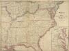
Map of the Seat of Civil War in America, September, 1862
Map of the Seat of Civil War in America, September, 1862. Produced by Davies & Co. in London, this map shows ten of the Confederate states, outlined in red, the Border States of Kentucky and Missouri, which remained within the Union, and lower portion of the Union states, outlined in green. The lower righter corner has an enlarged segment of the country detailing the sites of recent battles around lower Maryland, Washington, D.C. and Virginia. This includes Manassas Junction, where both battles of Bull Run had been fought prior to the map’s publication. Davies & Co.
Carte de la Louisiane, Maryland, Virginie, Caroline, Georgie, avec une partie de la Floride / C. Sepp. sculpsit.
from Charts and maps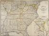
Map of the Seat of Civil War in America
Map of the Seat of Civil War in America. (Enlarged Plan of the Site of the most recent battles). This map, published by Davies & Co. in London, shows the state of America as things stood in July 1863. The Confederate borders are marked in red, the Union borders in green and the Border States in yellow. The separation between Virginia and West Virginia is also depicted. The smaller map in the right hand corner details where the most recent fighting had been, highlighting how volatile the region around the capitals of Washington, D.C., and Richmond were, with this area being the focus of attention in many of the maps produced. It is also possible to see the southern part of Pennsylvania in this map, marking the high–point of General Lee’s troops, who were pushed back out of Union territory after the Battle of Gettysburg in July 1863. Davies & Co.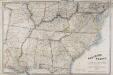
Map of the Southern States of North America, with the Forts, Harbours and Military Positions.
Map of the Southern States of North America, with the Forts, Harbours and Military Positions. Published by Wyld in 1862, Map of the Southern States of North America shows all the Confederate states, including the edge of Texas, and several of the Northern Border States too. Each state border is clearly defined. The map also labels ‘forts, harbours & military positions’, as well as marking the line between slave and free states, railways and canals. J. Wyld
A map of those parts of Virginia, North Carolina, South Carolina & Georgia which were the scenes of the most important operations of the southern armies
from Parts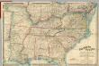
Map Of The Southern States of North America
1 : 2025000 Wyld, James, 1812-1887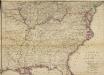
Woolley's new Map of the Seat of War in the Confederate States of America.
Woolley's new Map of the Seat of War in the Confederate States of America. Published in London, probably in 1861, Woolley’s New Map of the Seat of War in the Confederate States of America details the whole eastern half of the country. The red and green lines indicated which states held slaves and which states did not. The map shows all the Confederate states, excluding Texas, and shows how the Border States of Missouri and Kentucky were also slave-holding despite remaining part of the Union. H.G. Clarke & Co.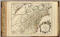
Cours de l'Ohio, Nlle. Angleterre, Nlle. York, Pensylvanie, Virginie, Caroline.
1 : 2900000 Robert de Vaugondy, Gilles, 1688-1766
Der Nördliche Theil der Vereinigten Staaten von Nord America
Hand-Atlas über alle Theile der Erde nach dem neuesten Zustande und über das Weltgebäude Stieler, Adolf bei Justus Perthes
Carte des Etats-unis : provinces méridionales.
from Parts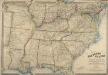
Map of the Southern States of North America, with the Forts, Harbours, and Military Positions
Map of the Southern States of North America, with the Forts, Harbours, and Military Positions. This map, published by Wyld in 1865, shows much of the Confederacy and the Border States as they were at the end of the Civil War. The divide between Virginia and West Virginia is marked, along with ‘forts, harbours & military positions’. The dark black lines indicated railway routes and it is notable how many more there are in the small segment of the Northern states displayed at the top of the map in comparison to the Confederate states. J. Wyld
Partie de l'Amérique septentrionale, qui comprend le cours de l'Ohio, la Nlle. Angleterre, la Nlle York, le New Jersey, la Pensylvanie, le Maryland, la Virginie, la Caroline
1 : 3000000