Maps of Westchester County

Yorktown town.
1 : 33600 Bien, Joseph Rudolf
Yorktown, Town.
1 : 31680 Beers, F. W. (Frederick W.)
Town of Yorktown, Westchester County, New York. (insets) Jefferson Valley. Shrub Oak.
1 : 31680 Beers, Frederick W.
Mohegan Lake
1 : 24000
Mohegan Lake
1 : 24000
Mohegan Lake
1 : 24000
Mohegan Lake
1 : 24000
Mohegan Lake
1 : 24000
234-235 Yorktown.
1 : 21600 G.W. Bromley & Co.
232-233 Yorktown. New Castle, Bedford.
1 : 21600 G.W. Bromley & Co.
230-231 Yorktown.
1 : 21600 G.W. Bromley & Co.
Small folder - S2
from Atlas of New York and vicinity : from actual surveys / by and under the direction of F. W. Beers, assisted by A. B. Prindle & others
10. Croton Landing-Yorktown.
1 : 80000 Servoss, R. D.
11. Mt. Kisco-Yorktown-Cross River.
1 : 80000 Servoss, R. D.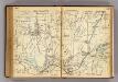
238-239 Yorktown, Somers.
1 : 21600 G.W. Bromley & Co.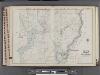
Westchester, V. 2, Double Page Plate No. 42 [Map bounded by Putnam County, North Salem]
From Vol. 2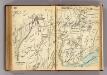
228-229 Yorktown, Somers.
1 : 21600 G.W. Bromley & Co.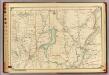
16 Atlas rural country district north of New York City.
1 : 18000 Hyde, E. Belcher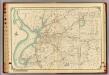
15 Atlas rural country district north of New York City.
1 : 18000 Hyde, E. Belcher
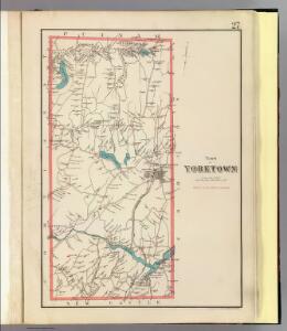
Westchester, Plate No. 27 [Map of Town of York Town] / prepared under the direction of Joseph R. Bien, from general surveys and official records.
From Atlas of Westchester County, New York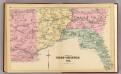
Part of West Chester Co.
1 : 14400 Bromley, George Washington; Bromley, Walter Scott; G.W. Bromley & Co.
Westchester, Double Page Plate No. 25 [Map of Town of Cortlandt] / prepared under the direction of Joseph R. Bien, from general surveys and official records.
From Atlas of Westchester County, New York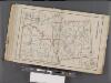
Westchester, Double Page Plate No. 30 [Map of Town of Bedford and Somers] / prepared under the direction of Joseph R. Bien, from general surveys and official records.
From Atlas of Westchester County, New York
Map of Westchester Co.
1 : 45000 G.W. Bromley & Co.
Plate 75: Town of Somers, Westchester Co. N.Y.
from County atlas of Westchester, New York. Published by J.B. Beers & Co., assisted by S.W. Wilson and others.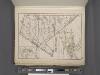
Westchester, Plate No. 29 [Map of Town of New Castle, Village of Mt.Kisco, Village of Chappaqua] / prepared under the direction of Joseph R. Bien, from general surveys and official records.
From Atlas of Westchester County, New York
West Point
1 : 62500
West Point
1 : 62500
West Point
1 : 62500
West Point
1 : 62500
West Point
1 : 62500
West Point
1 : 48000
West Point
1 : 62500
West Point
1 : 62500
West Point
1 : 62500
West Point
1 : 62500
West Point
1 : 62500
West Point
1 : 62500
West Point
1 : 62500
West Point
1 : 62500
West Point
1 : 62500
West Point
1 : 62500
West Point
1 : 62500
West Point
1 : 62500
West Point
1 : 62500
West Point
1 : 62500
West Point
1 : 62500
West Point
1 : 62500