Maps of Metropolitan France

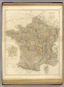
France.
1 : 1950000 Arrowsmith, John
Carte particuliere des postes de France
1 Karte auf 2 Blättern : Kupferdruck ; 65 x 59 cm Jaillot; Sanson chez H. Iaillot
France.
1 : 3000000 Colton, G.W.
Tableau de la France
1 Karte : Kupferdruck ; 48 x 50 cm Dupain-Triel; Cassini de Thury chez l'auteur rue des Noyers St. Jacques près St. Yves
Carte Physique de la Region Francaise.
1 : 2550000 Jouvet et Cie.
France Forestiere.
1 : 2550000 Jouvet et Cie.
France.
1 : 3000000 Colton, G.W.
Carte des routes de postes de l'Empire Français
1 : 2200000 Francie Pachoux, J. J. Tardieu, Pierre François
Carte Historique de la Region Francaise.
1 : 2550000 Jouvet et Cie.
Frankreich
Plastischer Schul-Atlas über alle Theile der Erde : in 24 Karten Woldermann, G Verlag von P. Eckerlein
France Industrielle et Commerciale.
1 : 2550000 Jouvet et Cie.
Kaiserthum Frankreich

Karte von Frankreich
1 : 2500000 Francie Fried, Franz Artaria & Comp.
France Administrative.
1 : 2550000 Jouvet et Cie.
Carte Particuliere Des Postes De France [Karte], in: Atlas nouveau, contenant toutes les parties du monde [...], Bd. 1, S. 147.
1 Karte aus Atlas Sanson, Nicolas Jaillot, Alexis Hubert und Mortier, Pieter
France.
1 : 3000000 Colton, G.W.
France.
1 : 3100000 Colton, G.W.
France Militaire.
1 : 2550000 Jouvet et Cie.
Carte des postes de France
1 Karte : Kupferdruck ; 64 x 54 cm Jean; Mondhare chez Mondhare et Jean rue St. Jean de Beauvais n.o 4
Frankreich
1 : 1865000 Francie Weiland, Karl Ferdinand im Verlage des geographischen Instituts
Frankreich
1 : 1900000 Francie Weiland, Karl Ferdinand im Verlage des geographischen Instituts
Frankreich
1 : 1865000 Francie Weiland, Karl Ferdinand im Verlage des geographischen Instituts
Frankreich

France.
1 : 3065000 Colton, G. Woolworth
France in Departments.
1 : 2450000 Hughes, William
France.
1 : 1964160 Arrowsmith, John
Carte Geologique de la Region Francaise.
1 : 2550000 Jouvet et Cie.
France.
1 : 1964160 Stanford, Edward
Carte physique et géographique de la France
1 : 2000000 Leuzinger, Rudolf Etab. top. & lith. de Wurster, Randegger & Co.