Maps of Netherlands

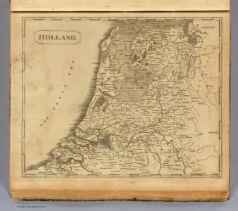
Holland.
1 : 1300000 Arrowsmith, Aaron; Lewis, Samuel
Holland.
1 : 1300000 Arrowsmith, Aaron; Lewis, Samuel
Niederlande, Belgien.
1 : 800000 Kiepert, Heinrich, 1818-1899
Holland and the other provinces of the United Netherlands.
from New & accurate description of the earth in all its empires, kingdoms and states
Carte de l'Angleterre avec les divisions Saxonnes
Anglie Raffelsperger, Franz Kitchin, Thomas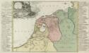
Summaria Descriptio Fresiae Vniversae; cum latissimè patuit nomen Post emigrationem Francorvm; Saxonvmq; accessionem
1 : 1400000 Mollova mapová sbírka Alting, Menso Broen, Gerrit de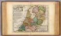
The United Provinces or Netherlands and Arx Britannica.
1 : 1450000 Moll, Herman, d. 1732
Summaria descriptio Fresiae Universae, cum latissime patuit nomen post emigrationem Francorum, Saxonumq. accessionem
auctore Mensone Alting Gerard de Broen fecit Amstelodami. [Amstelaedami] : [apud Henricum Wetstenium]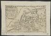
Oud Nederland zo als het zelve door de Batavieren, Marezaaten, Sturien, Frisiabonen ... en andere volkeren oudtijds bewoond wierd, naar de plaatsing der beste schrijveren.
1 : 3500000 Te Amsterdam : bij Arend Fokke Simonsz.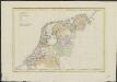
La Hollande
1 : 650000 W.C. v. Baarsel del. et sculp. [S.l.] : J. R. Poster excudit
Holland or the United Provinces.
from A new systeme of the mathematicks: containing I. Arithmetick, as well natural and decimal, as in species, or the principles of algebra. II. Practical geometry, together with the first six books of Euclid's Elements, as also the eleventh and twelfth, symbo
Provincie unite de Paesi Bassi
1 : 870000 descritte da Nicolo Sansone d'Abbeville ... e novamente intagliate da Gio. Batt.a Falda. Roma : Gio. Giacomo Rossi
Foederatum Belgium Nec non Ducatus Bremensis ac etiam Pars Fluminis Albis Peraccurate correcta auctore
1 : 840000 Mollova mapová sbírka Allard, Carel
Foederatae Belgicae tabvla
1 : 728000 Limburg (Belgie) Wit, Frederick de F. de Wit
Holland.
1 : 1457280 Lucas, Fielding Jr.
Britanniae sive Angliae regnum
Anglie Seutter, Matthäus Vilém Oranžský sumtibus Matthaei Seutteri
Nouvelle carte des departements de Hollande et des départemens circonvoisins de l'Empire Francais = Nieuwe kaart der departementen van Holland, en die der omliggende van het Fransche keizerrijk
1 : 760000 W.C. van Baarsel del. et sc. A Amsterdam : chez E. Maaskamp
Provinces Vnies de Pays Bas
1 : 861000 Nizozemsko
Provincie Vnite De Paesi Bassi
1 : 780000 Mollova mapová sbírka Sanson, Nicolas De Rossi, Giovanni Giacomo
A new and correct map of the seven provinces : drawn from the most approved maps and charts : the whole being regulated by astronomical observations
1 : 920000 by Eman Bowen. [London] : Tyndal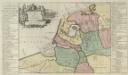
Descriptio veteris Agri Batavi et Frisi omnisque regionis quae hodie est in dicione VII. Foederatorvm cis et ultra Rhenvm
1 : 1100000 Mollova mapová sbírka Alting, Menso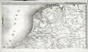
Carte de la république de France, 8
1 Blatt : 35 x 59 cm s.n.

Niederland u. Belgien.
1 : 1000000 Ziegler, J. M.
Magnae Britanniae pars meridionalis, in qua regnum Angliae tam in septem antiqua Anglo-saxonum regna quam in omnes hodiernas regiones accurate divisum hic ostenditur
Anglie Homann, Johann Baptist Visscher, Nicolaes Jansz. Ioh. Bapt. Homan[n
Holland.
1 : 1300000 Darton, William
La republica Battava
1 : 2400000 Nizozemsko Zatta, Antonio Zatta
Provinces unies des Pays-Bas avec leurs acquisitions dans la Flandre, le Brabant, le Limbourg, et le Lyege et les places qu'elles tiennent sur le Rhin dans le Duché de Cleves, et dans l'Archevesché et Eslectorat de Cologne
1 : 700000 par G. Valck. À Amsterdam : chez G. Valck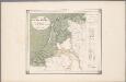
25. Nederland : de dijken weggedacht ..., uit: Geologische kaart van Nederland / door W.C.H. Staring ; bew. aan de Topographische Inrichting
1 : 200000 Winand Carel Hugo Staring 1808-1877; Topographische Inrichting, 's-Gravenhage 's-Gravenhage : Belinfante