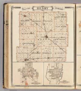
Maps of Henry County

Map of Henry County (with) New Castle, Knightstown.
1 : 126720 Baskin, Forster and Company
New Castle West
1 : 24000
New Castle West
1 : 24000
New Castle West
1 : 24000
New Castle East
1 : 24000
New Castle East
1 : 24000
New Castle East
1 : 24000
New Castle East
1 : 24000
New Castle West
1 : 24000
Shirley
1 : 24000
Shirley
1 : 24000
Dunreith
1 : 24000
Dunreith
1 : 24000
Dunreith
1 : 24000
Lewisville
1 : 24000
Lewisville
1 : 24000
Dunreith
1 : 24000
Lewisville
1 : 24000
Lewisville
1 : 24000
Sulphur Springs
1 : 24000
Sulphur Springs
1 : 24000
Sulpher Springs
1 : 24000
Mount Pleasant
1 : 24000
Mount Pleasant
1 : 24000
Mount Pleasant
1 : 24000
Mount Pleasant
1 : 24000
Knightstown
1 : 24000
Knightstown
1 : 24000
Knightstown
1 : 24000
Middletown
1 : 24000
Middletown
1 : 24000
Middletown
1 : 24000