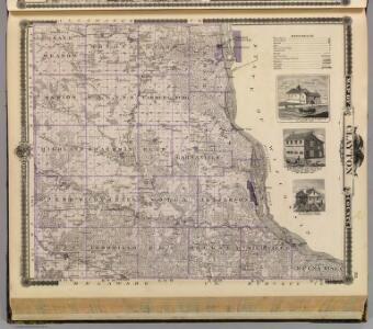
Maps of Clayton County

Map of Clayton County and buildings in McGregor, State of Iowa.
1 : 154800 Andreas, A. T. (Alfred Theodore), 1839-1900
Elkader
1 : 125000
Elkader
1 : 125000
Elkader
1 : 125000
Elkader
1 : 125000
Elkader
1 : 24000
Littleport
1 : 24000
Garnavillo
1 : 24000
Guttenberg
1 : 24000
Saint Olaf
1 : 24000
Farmersburg
1 : 24000
Clayton
1 : 24000
Clayton
1 : 24000
Clayton
1 : 24000
Volga
1 : 24000
Beetown
1 : 24000
Beetown
1 : 24000
Gunder
1 : 24000
Bloomington
1 : 24000
Bloomington
1 : 24000
Early map of Prairie du Chien, Wisconsin, and McGregor, Iowa
This map is ink and watercolor on paper and shows the main channel and sand bars in the Mississippi River between villages.
Prairie du Chien, Wisconsin
1 : 12200 This map includes an index of streets, government and historic buildings, hospitals, schools, places of recreation, churches, cemeteries, and other miscellaneous buildings and points of interest. This map was likely given out by People's State Bank. Deckert, Garrett Peoples State Bank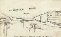
Fort Crawford, Prairie du Chien, 1829-30.
This map is ink on cardboard and shows the location of military forts over the course of years. Also shown are points of interest, streets, the Mississippi River, and Marais De St Feriole.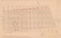
Plat of Fort Crawford Military Tract, Wisconsin, 1864.
This map is ink, pencil, and color on paper and shows numbered lots and labeled streets. The bottom margin of the map reads: "Recorded in the Registry of deeds for Crawford County, Wisconsin, on the 12 day of January A.D. 1864 in book no. 18 of deeds on page 279."
Map of Prairie du Chien, Wisconsin
This map is ink, color, and pencil on paper and shows streets, farm lots, and a church. Hand written notes appear at the bottom of the map and are very light.
Edgewood
1 : 24000
Garber
1 : 24000
Colesburg
1 : 24000
Colesburg
1 : 24000
Turkey River
1 : 24000
Turkey River
1 : 24000