Maps of Hudson County

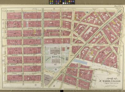
South of 14th Street Part of Wards 2, 3, 4, 5, and 6.
from Atlas of the City of New York. Vol. 4.
Manhattan, V. 4, Double Page Plate No. 5 [Map bounded by Worth St., New Bowery, Pearl St., Cold St., Beekman St., Barclay St., College Place, West Broadway]
From Vol. 4
Pl. 2: wards 2-6.
1 : 1800 Bromley, George Washington; Bromley, Walter Scott
Part of Section 1 : Plate 8.
from Atlas of the borough of Manhattan, city of New York.
Part of Section 1 : Plate 6.
from Atlas of the borough of Manhattan, city of New York.
Plate 6, Part of Section 1: [Bounded by Reade Street, Duane Street, New Chambers Street, Roosevelt Street, Cherry Street, Franklin Square, Frankfort Street, Cliff Street, Beekman Street, Gold Street and Ann Street.]
from Atlas of the city of New York, borough of Manhattan. From actual surveys and official plans / by George W. and Walter S. Bromley.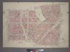
Plate 8, Part of Section 1: [Bounded by Franklin Street, Bayard Street, Bowery, Chatham Square, New Bowery, Madison Street, New Chambers Street, William Street, Duane Street, Reade Street and Broadway.]
from Atlas of the city of New York, borough of Manhattan. From actual surveys and official plans / by George W. and Walter S. Bromley.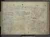
[Plate 9: Map bounded by Pearl Street, Chatham Street, Chambers Street, Rose Street, Frankfort Street, Murray Street, Church Street; Including Duane Street, City - Hall Place, Reade Street, Warren Street, Broadway, Elm Street, Centre Street
from Maps of the city of New-York.
[Plate 9: Map bounded by Pearl Street, Chatham Street, Duane Street, Rose Street, Frankfort Street, City Hall Square, Murray Street, Church Street]
from Maps of the city of New York.
Plate 28: Map bounded by Leonard Street, Centre Street, Chambers Street, Broadway, Reade Street, West Broadway.
from Maps of the city of New York / surveyed under directions of insurance companies of said city.
[3rd Ward. Plate 5: Map bounded by College Place, West Broadway, Reade Street, Broadway, Park Place; Including Church Street, Murray Street, Warren Street, Chambers Street]
from Maps of the city of New York.
Plate 9: Map bounded by Greenwich Street, Barclay Street, College Place, West Broadway, Reade Street, Broadway, Vesey Street.
from Maps of the city of New York / surveyed under directions of insurance companies of said city.
Plate 25: Map bounded by Chambers Street, Center Street, White Street, Orange Street, Bayard Street, Bowery, Chatham Street, Park Row, Chatham Street, Broadway.
from Maps of the city of New York / surveyed under directions of insurance companies of said city.
[4th Ward. Plate 9: Map bounded by Roosevelt Street, Oak Street, Pearl Street, Rose Street, Duane Street, Chatham Street; Including William Street, Madison Street]
from Maps of the city of New York.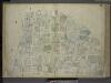
[Plate 6: Map bounded by Broadway, Park Row, Frankfort Street, Gold Street, Maiden Lane; Including Nassau Street, Theater Alley, Dutch Street, William Street, Platt Street, John Street, Fulton Street, Ann Street, Beekman Street, Spruce
from Maps of the city of New-York.
[Plate 14: Map bounded by Canal Street, Mott Street, Cross Street, Mulberry Street, Chatham Street, Pearl Street, Elm Street]
from Maps of the city of New York.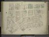
[Plate 14: Map bounded by Elm Street, Canal Street, Mott Street, Park Street, Mulberry Street, Chatham Street, Pearl Street; Including Centre Street, Park Street, Mission Place, Baxter Street, Mulberry Street, Worth Street, Leonard Stree
from Maps of the city of New-York.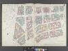
Manhattan, V. 1, Double Page Plate No. 14 [Map bounded by Elm St., Canal St., Mott St., Park Row, Pearl St.]
From Atlas 107. Vol. 1, 1894.
[Plate 6: Map bounded by City Hall Square, Frankfort Street, Gold Street, Maiden Lane, Broadway, Park Row]
from Maps of the city of New York.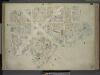
[Plate 10: Map bounded by James Street, South Street, Dover Street, Rose Street, Duane Street, Chatham Street; Including Roosevelt Street, Chesnut Street, Pearl Street, Franklin Square, Bowery, Chambers Street, Cliff Street, Jacob Street, Gold St
from Maps of the city of New-York.
[Plate 6: Map bounded by Broadway, Park Row, Spruce Street, Gold Street, Liberty Street]
from Maps of the city of New York / surveyed under directions of insurance companies of said city.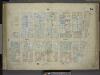
[Plate 15: Map bounded by Church Street, Canal Street, Elm Street, Pearl Street; Including Franklyn Place, Broadway, Benson Street, Courtlandt Alley, Worth Street, Leonard Street, Franklin Street, White Street, Walker Street, Lispenard St
from Maps of the city of New-York.
Manhattan, V. 1, Plate No. 9 [Map bounded by Pearl St., Rose St., Frankfort St., Elm St.]
From Atlas 107. Vol. 1, 1894.
Manhattan, V. 1, Plate No. 6 [Map bounded by Broadway, Frankfort St., Gold St., Fulton St.]
From Atlas 107. Vol. 1, 1894.
Manhattan, V. 1, Plate No. 25 [Map bounded by Worth St., Baxter St., William St., New Chambers St., Centre St.]
From Atlas 109. Vol. 1, 1905.
Plate 10: Map bounded by Nassau Street, Roosevelt Street, Oak Street, Oak Street, Pearl Street, Frankfort Street, Cliff Street, Ferry Street, Spruce Street
from Maps of the city of New York / surveyed under directions of insurance companies of said city.
Manhattan, V. 1, Plate No. 8 [Map bounded by Thomas St., Church St., Murray St., Greenwich St.]
From Atlas 107. Vol. 1, 1894.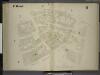
[4th Ward. Plate 8: Map bounded by Gold Street, Frankfort Street, Rose Street, Madison Street, Pearl Street, Oak Street, Franklin Square, Ferry Street; Jacob Street, Vandewater Street, Cliff Street]
from Maps of the city of New York.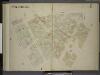
[2nd & 4th Wards. Plate 7: Map bounded by Park Row, Chatham Street, Duane Street, Rose Street, Frankfort Street, Gold Street, Beekman Street; Including Nassau Street, William Street, North William Street, William Street, Spruce Street]
from Maps of the city of New York.