Maps of Queens County

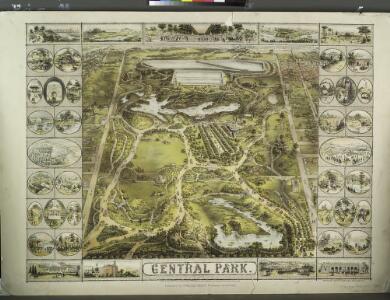
Central Park
From Manhattan
Sackersdorff Farm Set.
from Maps of farms commonly called the Blue book, 1815 : drawn from the original on file in the street commissioner's office in the City of New York, together with lines of streets and avenues / laid out by John Randel, jr., 1819-20.
Central Park
from Manhattan
41. Central Park, Blackwells Island.
1 : 6000 G.W. Bromley & Co.; Geo. W. Bromley & E. Robinson
[Plate 22: Bounded by Sixth Avenue, Central Park South, Fifth Avenue, E. 64th Street, Lexington Avenue, and E. 47th Street.]
from Atlas of the city of New York, borough of Manhattan. From actual surveys and official plans / by George W. and Walter S. Bromley.
Manhattan, Double Page Plate No. 22 [Map bounded by 6th Ave., E. 64th St., Lexington Ave., E. 47th St.]
From Atlas of the city of New York, Manhattan Island. From actual surveys and official plans
Part of Section 5 : New York City.
from Atlas of the city of New York, Manhattan Island. From actual surveys and official plans / by George W. and Walter S. Bromley.
[Plate 18: Bounded by E. 64th Street, Avenue A, E. 52nd Street, W. 52nd Street, Sixth Avenue, W. 59th Street and Fifth Avenue.]
from Atlas of the city of New York : embracing all territory within its corporate limits from official records, private plans & actual surveys / by and under the supervision of E. Robinson & R.H. Pidgeon, civil engineers.
Sackersdorff Farm Set.
from Maps of farms commonly called the Blue book, 1815 : drawn from the original on file in the street commissioner's office in the City of New York, together with lines of streets and avenues / laid out by John Randel, jr., 1819-20.
Sackersdorff Farm set.
from Maps of farms commonly called the Blue book, 1815 : drawn from the original on file in the street commissioner's office in the City of New York, together with lines of streets and avenues / laid out by John Randel, jr., 1819-20.
Sackersdorff Farm set.
from Sackersdorf Farm Set.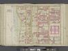
Manhattan, Double Page Plate No. 26 [Map bounded by W. 86th St., Central Park W., W. 75th St., Hudson River]
From Atlas of the city of New York, Manhattan Island. From actual surveys and official plans
Part of Section 4 : New York City.
from Atlas of the city of New York, borough of Manhattan. From actual surveys and official plans / by George W. and Walter S. Bromley.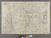
Part of Ward 22, New York City.
from Atlas of the city of New York : embracing all territory within its corporate limits from official records, private plans & actual surveys / by and under the supervision of E. Robinson & R.H. Pidgeon, civil engineers.
[Plate 26: Bounded by W. 86th Street, Central Park West (8th Avenue), W. 75th Street and Hudson River.]
from Atlas of the city of New York, Manhattan Island. From actual surveys and official plans / by George W. and Walter S. Bromley.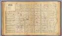
19. Ward 19.
1 : 2400 G.W. Bromley & Co.; Geo. W. Bromley & E. Robinson
Part of Wards 12 & 22, New York City.
from Atlas of the city of New York : embracing all territory within its corporate limits from official records, private plans & actual surveys / by and under the supervision of E. Robinson & R.H. Pidgeon, civil engineers.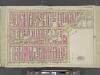
Manhattan, Double Page Plate No. 23 [Map bounded by 9th Ave., W. 59th St., 6th Ave., W. 47th St.]
From Atlas of the city of New York, Manhattan Island. From actual surveys and official plans
[Plate 23: Bounded by Ninth Avenue, Columbus Avenue, W. 64th Street, Central Park West, Columbus Circle, Central Park South, Sixth Avenue, and W. 47th Street.]
from Atlas of the city of New York, borough of Manhattan. From actual surveys and official plans / by George W. and Walter S. Bromley.
Part of Section 3 : New York City.
from Atlas of the city of New York, Manhattan Island. From actual surveys and official plans / by George W. and Walter S. Bromley.
Manhattan, V. 7, Plate No. 64 [Map bounded by Central Park West, 5th Ave.]
From Atlas 120. Vol. 7, 1902.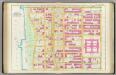
Pl. 26: ward 22.
1 : 1800 Bromley, George Washington; Bromley, Walter Scott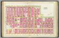
Pl. 22: ward 19.
1 : 1800 Bromley, George Washington; Bromley, Walter Scott
[Plate 84: Bounded by E. 59th Street, Third Avenue, E. 53rd Street, and Fifth Avenue.]
from Atlas of the borough of Manhattan, city of New York.
Part of Section 5 : Plate 78.
from Atlas of the borough of Manhattan, city of New York.
[Plate 104: Bounded by E. 65th Street, Third Avenue, E. 59th Street, and (Central Park) Fifth Avenue.]
from Atlas of the borough of Manhattan, city of New York.
[Plate 91: Bounded by W. 77th Street, Central Park West, W. 71st Street, Broadway, and Amsterdam Avenue.]
from Atlas of the borough of Manhattan, city of New York.
[Plate 77: Bounded by W. 53rd Street, Fifth Avenue, W. 47th Street, and Seventh Avenue.]
from Atlas of the borough of Manhattan, city of New York.
[Plate 83: Bounded by Central Park South, Fifth Avenue, W. 53rd Street, and Seventh Avenue.]
from Atlas of the borough of Manhattan, city of New York.