Maps of Queens County

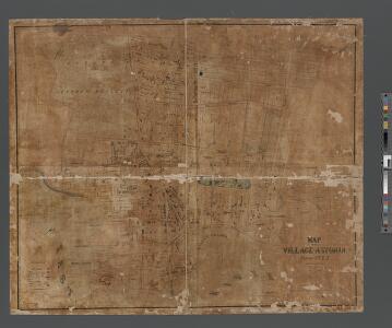
Map of the Village of Astoria, queens Co., N.Y.
From Queens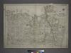
[Plate 2: Bounded by (East River) Vernon Avenue, Boulevard, Fulton Avenue, Mill Street, Orchard Street, Boulevard, Hoyt Avenue, Barclay Street, Woolsey Avenue, Rapelje Avenue and Freeman Avenue.]
from Atlas of the city of New York, borough of Queens, Long Island City, Newtown, Flushing, Jamaica, Far Rockaway, from actual surveys and official plans / by George W. and Walter S. Bromley.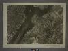
9A - N.Y. City (Aerial Set).
from Sectional aerial maps of the City of New York / [photographed and assembled under the direction of the chief engineer, July 1st, 1924].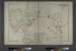
Astoria. Part of Long Island City, Town of Newtown, Queens Co. L.I.
from Atlas of Long Island, New York. From recent and actual surveys and records.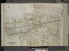
Queens, Vol. 2, Double Page Plate No. 8; Part of Long Island City Ward One (Part of Old Wards 4 and 5); [Map bounded by Hoyt Ave., Emily Terrace, Edward St., Barclay St., Vanalst Ave., Woolsey Ave., De Bevoise Ave. (Bradford St.), Lockwood St.,
from First and second wards: Long Island City and Newtown.
Map of 465 valuable building lots in the village of Astoria, Long Island.
from Queens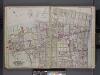
Queens, V. 2, Double Page Plate No. 8; Part of Long Island City, Ward 1; [Map bounded by East River, Astoria Park, Woolsey Ave., 2nd Ave., Patterson Ave., Mills St.] / by and under the supervision of Hugo Ullitz.
From v. 2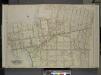
Queens, Vol. 2, Double Page Plate No. 8; Part of Long Island City Ward One ( Part of Old Wards Four and Five); [Map bounded by Boulevard, Emily Terrace, Edmard St., Barclay St., Woolsey Ave., De Bevoise Ave. (Bradford St.), Jamaica Ave., Fulto
from First and second wards: Long Island City and Newtown.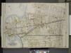
Queens, Vol. 2, Double Page No. 8; Part of Long Island City Ward One (Part of Old Wards 4 & 5).; [Map bounded by Woolsey Ave., De Bevoise Ave., Ely Ave., Flushing Ave., Newtown Ave., Van Alst Ave., Hoyt Ave., Hopkins Ave., Grand Ave., Ful
from Long Island City.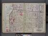
Queens, V. 2, Double Page Plate No. 7; Part of Long Island City, Ward 1; [Map bounded by Patterson Ave., 4th Ave., Webster Ave., East Channel] / by and under the supervision of Hugo Ullitz.
From v. 2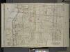
Queens, Vol. 2, Double Page Plate No. 7; Part Long Island City Ward One (Part of Old Wards 3 and 4); [Map bounded by Jamaica Ave., Rapelje Ave. (4th Ave.); Including Washington Ave., Webster Ave., East Channel.]
from First and second wards: Long Island City and Newtown.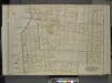
Queens, Vol. 2, Double page plate No. 7; Part of Long Island City Ward One (Part of Old Wards Three and Four); [Map bounded by Jamaica Ave., Rapelje Ave. (4th Ave.), Washington Ave., Webster Ave.; Including Rutledge St., Graham Ave., Vernon Ave., Boul
from First and second wards: Long Island City and Newtown.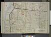
Queens, Vol. 2, Double Page No. 7; Part of Long Island City Ward One (Part of Old Wards 3 & 4); [Map bounded by Webster Ave., Washington Ave., Pierce Ave., Graham Ave., Franklyn Ave., Vernon Ave., Broadway, Jamaica Ave., Rapelje Ave., 4th Ave
from Long Island City.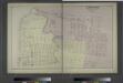
Ravenswood. Part of Long Island City. Queens Co. L.I.
from Atlas of Long Island, New York. From recent and actual surveys and records.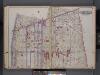
Queens, V. 2, Double Page Plate No. 9; Part of Long Island City, Ward 1; [Map bounded by Woolsey Ave., Potter Ave., Bowery Bay Rd., Patterson Ave., 2nd Ave.] / by and under the supervision of Hugo Ullitz.
From v. 2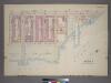
Plate 32, Part of Section 5: [Bounded by (East River Park) East End Avenue, E. 85th Street, Avenue A, E. 83rd Street and (East River) E. 89th Street.]
from Atlas of the city of New York, borough of Manhattan. From actual surveys and official plans / by George W. and Walter S. Bromley.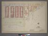
Plate 32, Part of Section 5: [Bounded by Avenue A, (East River) East End Avenue and E. 85th Street.]
from Atlas of the city of New York, borough of Manhattan. From actual surveys and official plans / by George W. and Walter S. Bromley.
Queens V. 2, Plate No. 36 [Map bounded by 2nd Ave., Flushing Ave., Crescent, Hoyt Ave.]
From Atlas 134. Vol. 2, 1915.
Part of Section 5: Plate 117.
from Atlas of the borough of Manhattan, city of New York.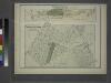
Part of Astoria. Long Island City, Queens Co. L.I.
from Atlas of Long Island, New York. From recent and actual surveys and records.
Part of Sections 5 & 6 : New York City.
from Atlas of the city of New York, borough of Manhattan. From actual surveys and official plans / by George W. and Walter S. Bromley.
[Plate 31: Bounded by Second Avenue, E. 101st Street, East River, Avenue B and and E. 84th Street.]
from Atlas of the city of New York, Manhattan Island. From actual surveys and official plans / by George W. and Walter S. Bromley.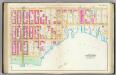
Pl. 31: wards 12, 19.
1 : 1800 Bromley, George Washington; Bromley, Walter Scott
Part of Section 5: Plate 116.
from Atlas of the borough of Manhattan, city of New York.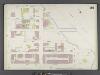
Manhattan, V. 8, Double Page Plate No. 161 [Map bounded by E. 93rd St., East River, E. 88th St., 1st Ave.]
From Atlas 122. Vol. 8, 1896.
Queens V. 2, Plate No. 21 [Map bounded by 4th Ave., Broadway, Crescent, Jamaica Ave.]
From Atlas 134. Vol. 2, 1915.
Queens V. 2, Plate No. 57 [Map bounded by Goodrich, Woolsey Ave., Van Alst Ave., Potter Ave.]
From Atlas 134. Vol. 2, 1915.
Queens V. 2, Plate No. 23 [Map bounded by 9th Ave., Broadway, 4th Ave., Jamaica Ave.]
From Atlas 134. Vol. 2, 1915.
Queens V. 2, Plate No. 52 [Map bounded by Woolsey Ave., Barclay, Hoyt Ave., Boulevard]
From Atlas 134. Vol. 2, 1915.