Maps of Hoboken
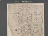
[Map of New York City between Canal and 22nd Sts?? and Broadway and the Hudson River School District No. 9, showing population and school attendance figures.]
From Manhattan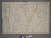
Part of the 23rd Ward, New York City.
from Atlas of the city of New York : from official records, private plans & actual surveys / compiled under the supervision of E. Robinson & R. H. Pidgeon.
Block distribution of children of 4 to 18 years of age for Chelsea and Greenwich for 1910.
From Manhattan
"Where all the Village meet to eat" - An accurate and detailed map of Greenwich Village and Environment.
From Manhattan
Key
From Atlas 42.53. Vol. 3, 1895.
Map of the city of New-York extending northward to Fiftieth St. / surveyed and drawn by John F. Harrison, C.E.
from Manhattan
Map showing the old high water lines along the shores of Brooklyn & New York together the the pier lines as established by law.
From Manhattan
Sheet 6: [Bounded by W. Twentieth Street, Sixth Avenue, Carmine Street, Bleecker Street, Hancock Street, W. Houston Street, Varick Street, Charlton Street, Hudson Street, King Street, West Street and 10th Avenue.]
from Plan of New York City, from the Battery to Spuyten Duyvil Creek. Showing every lot and building thereon; old farm lines, strreet numbers at the corners of blocks, railroads, steamboat landings, bulkhead and pier lines, etc. Based on the surveys made by Messrs. Randall & Blackwell, and on the special survey by J. F. Harrison.
Sheet 7: [Bounded by Mc Dougall Street, Houston Street, Hancock Street, Bleecker Street, Sixth Avenue, E, Twentieth Street,Avenue A, Delancy Parkway, Bowery and Spring Street.]
from Plan of New York City, from the Battery to Spuyten Duyvil Creek. Showing every lot and building thereon; old farm lines, strreet numbers at the corners of blocks, railroads, steamboat landings, bulkhead and pier lines, etc. Based on the surveys made by Messrs. Randall & Blackwell, and on the special survey by J. F. Harrison.
Map showing the old farms : from 4th to 28th Street, east of 6th Avenue, New York / compiled from authentic documents by Edwin Smith, city surveyor, 1831.
from Manhattan
Map of the real estate in the city of New York : between the south side of Washington Parade, 4th St., and the north side of Bellevue, 28th Street / compiled from authentic documents by Edwin Smith, city surveyor, 1831 ; engd. by D.R. Harrison.
from Manhattan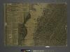
The city of New York / Will L. Taylor, chief draughtsman.
from Whole
Map showing the high and low water mark and the original city grants of lands under water made to various parties from 1686 to 1873, extending from Battery to Fifty-first Street, Hudson and East Rivers, New York City, also the several pier and bulkhead l
from Whole
Part of Wards 16 &20, New York City.
from Atlas of the city of New York : embracing all territory within its corporate limits from official records, private plans & actual surveys / by and under the supervision of E. Robinson & R.H. Pidgeon, civil engineers.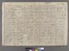
Plate 12: Bounded by W. 27th Street, E. 27th Street, First Avenue, E. 26th Street, Avenue A, E. 14th Street, and Sixth Avenue.
from Atlas of the city of New York : embracing all territory within its corporate limits from official records, private plans & actual surveys / by and under the supervision of E. Robinson & R.H. Pidgeon, civil engineers.
Sackersdorff Farm Set.
from Sackersdorf Farm Set.
Sheet 9: [Bounded by Twelfth Avenue, W. Fortieth Street, Sixth Avenue and W. Twentieth Street.]
from Plan of New York City, from the Battery to Spuyten Duyvil Creek. Showing every lot and building thereon; old farm lines, strreet numbers at the corners of blocks, railroads, steamboat landings, bulkhead and pier lines, etc. Based on the surveys made by Messrs. Randall & Blackwell, and on the special survey by J. F. Harrison.
Sheet 10: [Bounded by E. Fortieth Street, First Avenue, E. Twentieth Street and Sixth Avenue.]
from Plan of New York City, from the Battery to Spuyten Duyvil Creek. Showing every lot and building thereon; old farm lines, strreet numbers at the corners of blocks, railroads, steamboat landings, bulkhead and pier lines, etc. Based on the surveys made by Messrs. Randall & Blackwell, and on the special survey by J. F. Harrison.
Plate 13: Bounded by W. 25th Street, Seventh Avenue, W. 14th Street, [Hudson River, Pierhead Line, Piers 57-62], and Thirteenth Avenue.]
from Atlas of the city of New York, borough of Manhattan. From actual surveys and official plans / by George W. and Walter S. Bromley.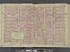
Manhattan, Double Page Plate No. 11 [Map bounded by E. 14th St., 1st Ave., W. 3rd St., 6th Ave.]
From Atlas of the city of New York, Manhattan Island. From actual surveys and official plans
Part of Section 2 : New York City.
from Atlas of the city of New York, borough of Manhattan. From actual surveys and official plans / by George W. and Walter S. Bromley.
Manhattan, Double Page Plate No. 14 [Map bounded by W. 25th St., 2nd Ave., E. 14th St., 7th Ave.]
From Atlas of the city of New York, Manhattan Island. From actual surveys and official plans
Manhattan, Double Page Plate No. 13 [Map bounded by W. 25th St., 7th Ave., W. 14th St., Hudson River]
From Atlas of the city of New York, Manhattan Island. From actual surveys and official plans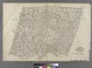
Part of Wards 9 & 15, New York City.
from Atlas of the city of New York : embracing all territory within its corporate limits from official records, private plans & actual surveys / by and under the supervision of E. Robinson & R.H. Pidgeon, civil engineers.
Part of Section 3 : New York City.
from Atlas of the city of New York, borough of Manhattan. From actual surveys and official plans / by George W. and Walter S. Bromley.
[Plate 10: Bounded by W. 14th Street, Sixth Avenue, Cornelia Street, Bleecker Street, Barrow Street, Bedford Street, Christopher Street, Hudson Street, W. 10th Street, Washington Street, Charles Street, and [Hudson River, Piers 48-55] West Street.]
from Atlas of the city of New York, borough of Manhattan. From actual surveys and official plans / by George W. and Walter S. Bromley.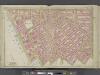
Manhattan, Double Page Plate No. 10 [Map bounded by W. 14th St., 6th Ave., Bedford St., Hudson River]
From Atlas of the city of New York, Manhattan Island. From actual surveys and official plans
Part of Section 2 : New York City.
from Atlas of the city of New York, Manhattan Island. From actual surveys and official plans / by George W. and Walter S. Bromley.
Part of Section 2 : New York City.
from Atlas of the city of New York, Manhattan Island. From actual surveys and official plans / by George W. and Walter S. Bromley.
![[Map of New York City between Canal and 22nd Sts?? and Broadway and the Hudson River School District No. 9, showing population and school attendance figures.]](https://images-2.georeferencer.com/images/iiif/340565743925/full/,300/0/native.jpg)

