Maps of Mexico
Amérique Septentrionale publiée sous les auspices de Monseigneur le Duc d'Orleans prémier prince du sang / par le Sr. D'Anville.
from Charts and maps
New Spain ; Guiana.
from A new systeme of the mathematicks: containing I. Arithmetick, as well natural and decimal, as in species, or the principles of algebra. II. Practical geometry, together with the first six books of Euclid's Elements, as also the eleventh and twelfth, symbo
Pascaerte van Westindien : de vaste kusten en de Eylanden.
from De zee-atlas, ofte, Water-weereld : waer in vertoont werden alle de zee-kusten van het bekende des aerd-bodems : seer dienstigh voor alle heeren en kooplieden, als oock voor alle schippers en stuurlieden / gesneden, gedruckt en uytgegeven t'Amsteldam.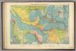
Cent. Amer., W.I. ports
1 : 10000000 Philip, George
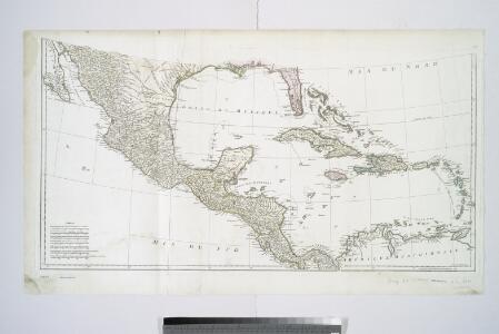
A new mapp of the Empire of Mexico describing the continent to the Istmus of Panama : together with all the islands in the North Sea / F. Lamb sculp.
from Charts and maps
New Map Of The Union.
1 : 6000000 Johnson, D. Griffing
Messico, ouvero Nuova-Spagna : che contiene il Nuovo Messico, la California con una parte de paesi adjacenti / G. Pitteri scr.
from Mexico
Regni Mexicani seu Novae Hispaniae, Floridae, Novae Angliae, Carolinae, Virginiae et Pensylvaniae necnon insularum archipelagi Mexicani in America Septentrionali
from Charts and maps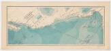
Explorations of the U. S. Fish Commission steamer Albatross : Lieut. Comdr. Z. L. Tanner U.S.N. Comdg. : Februrary to April 1891
United States Fish Commission Printed for the Museum of Comparative Zoology, Harvard University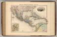
Mexique, Amerique Centrale et Antilles.
1 : 13000000 Migeon, J.
Mexique, Amerique Centrale, les Antilles.
1 : 11000000 Garnier, F. A., 1803-1863
Regni Mexicani seu Novae Hispaniae, Ludovicianae, N. Angliae, Carolinae, Virginiae, Pensylvaniae, ... in America Septentrionali
from John H. Levine Collection
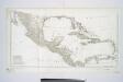
Map of the United States of America, the British provinces, Mexico, the West Indies and Central America, with part of New Granada and Venezuela / map drawn by Geo. W. Colton; engraved by John M. Atwood; border desig'd. & eng'd. by W.S. Barnard.
from Parts George W. Colton; John M. Atwood; W. S. Barnard,
America septentrionalis
1 Karte : Kupferdruck ; 45 x 53 cm Janssonius excudit Ioannes Janssonius
America septentrionalis
1 Karte : Kupferdruck ; 45 x 53 cm Valck; Schenk penes Gerardum Valk et Petrum Schenk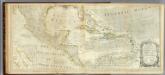
An Accurate Map Of North America. (Southern section)
1 : 5400000 Jefferys, Thomas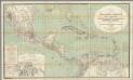
H. Kiepert's Karte des nordlichen Tropischen America.
1 : 3600000 Smith, Martin Luther, 1819-1866
A new map of the north parts of America claimed by France under ye names of Louisiana, Mississipi, Canada and New France, with ye adjoyning territories of England and Spain ... / ... laid down according to the newest and most exact observations by H. Mol
from The world described, or, A new and correct sett of maps : shewing the kingdoms and states in all the known parts of the earth, with the principal cities, and most considerable towns in the world ... / ... by Herman Moll, geographer ...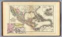
Mexico, Central America, West Indies.
1 : 12000000 Mitchell, Samuel Augustus
Cuba.
1 : 3300000 Mitchell, Samuel Augustus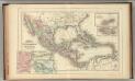
Mexico, Central America, West Indies.
1 : 12000000 Mitchell, Samuel Augustus Jr.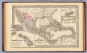
Mexico, Central America, West Indies.
1 : 12000000 Mitchell, Samuel Augustus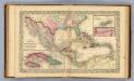
Mexico, Central America, West Indies.
1 : 12000000 Williams, W. (Wellington)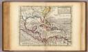
Map of the West-Indies, Mexico or New Spain.
1 : 21000000 Moll, Herman, d. 1732
Texas, der Mexicanische Bundesstaat, der Mittelamericanische Bundesstaat, und West Indien
Schul-Atlas in 36 Karten Völter, Daniel Verlag der J.M. Dannheimer'schen Buchhandlung
Composite: A Map of the British Empire in America.
1 : 2000000 Popple, Henry
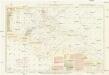
Pilot chart of the Central American waters
1 : 6000000 Mexický záliv Maury, Matthew Fontaine Hydrographic Office
Pilot chart of the Central American waters
1 : 6000000 Mexický záliv Maury, Matthew Fontaine Hydrographic Office
Pilot chart of the Central American waters
1 : 6000000 Mexický záliv Maury, Matthew Fontaine Hydrographic Office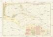
Pilot chart of the Central American waters
1 : 6000000 Mexický záliv Maury, Matthew Fontaine Hydrographic Office