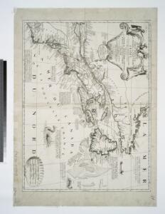
Maps of Appalachian Mountains

Partie orientale du Canada ou de la Nouvelle France : ou sont les provinces, ou pays de Sagvenay, Canada, Acadie etc., les peuples, ou nations des Etechemins, Iroquois, Attiquameches etc., auec la Nouvelle Angleterre, la Nouvelle Ecosse, la Nouvelle Yorc
from Canada
A new and correct map of North America : in which the places of the principal engagements during the present war are accurately inserted
from Parts
Partie orientale du Canada ou de la Nouvelle France : ou sont les provinces, ou pays de Sagvenay, Canada, Acadie etc., les peuples, ou nations des Etechemins, Iroquois, Attiquameches etc., auec la Nouvelle Angleterre, la Nouvelle Ecosse, la Nouvelle Yorc
from Charts and maps
Mappa geographica Americae Septentrionalis : ad emendatiora exemplaria adhuc edita jussu Acad. reg. scient. et eleg. litt. descripta.
from Charts and maps
Carte nouvelle de l'Amerique angloise: contenant la Virginie, Mary-Land, Caroline, Pensylvania, Nouvelle Iorck, N. Iarsey, N. France, et les terres nouvellement decouerte dressé sur les relations les plus nouvelles / par le Sieur S.
from John H. Levine Collection le Sieur S.,
Composite: L'Amerique Septentrionale.
1 : 10050000 Bonne, Rigobert, 1727-1794
Le Canada, ou Nouvelle France, &c. : tireé de diverses relations des Francois, Anglois, Hollandois, &c. / par N. Sanson d'Abb'. geogr. ordre. du Roy ; A.d. Winter schulp.
from Charts and maps
Map of part of the United States of North America : with the territory of the Illinois on the Ohio, particularly designed to illustrate Birkbeck's journey / Neele & Son, sc., 352 Strand.
from Parts
North America from the French of Mr. D'Anville : improved with the back settlements of Virginia and course of Ohio : illustrated with geographical and historical remarks.
from A summary, historical and political, of the first planting, progressive improvements, and present state of the British settlements in North-America ... By William Douglass, M.D. ... Boston, New-England, Printed:
Le Canada Ou Partie Dela Nouvelle France. Contenant La Terre De Labrador La Nouvelle France, Les Isles De Terre Neuve, de Nostredame &c: [Karte], in: Atlas nouveau, contenant toutes les parties du monde [...], Bd. 2, S. 250.
1 Karte aus Atlas Sanson, Nicolas Jaillot, Alexis Hubert und Mortier, Pieter
Tierra nveva.
from Charts and maps Sesssa?: [Venice]; Ruscelli, Girolamo; Gastaldi, Giacomo,
An exact map of North and South Carolina & Georgia : with east and west Florida from the latest discoveries / J. Lodge, sculp.
from Parts
Nova tabula geographica complectens borealiorem Americae partem.
from Charts and maps
Gulf-Stream.
1 : 15000000 Vincent
A map of the British dominions in North America, according to the Treaty in 1763 / by Peter Bell, geographer, 1772.
from The history of the British dominions in North America: from the first discovery of that vast continent by Sebastian Cabot in 1497, to its present glorious establishment as confirmed by the late treaty of peace in 1763 ...
Canada et Louisiane / par le Sr. le Rouge ingénieur géographe du Roy.
from Charts and maps
Theatre de la guerre presente en Amerique.
from Revolutionary War, 1775-1783
A new map of the British colonies in North America : shewing the seat of the present war, taken from the best surveys, compared with and improved from manuscripts of several noblemen and gentlemen / by John Andrews.
from Charts and maps
Carte de la Nouvelle France: où se voit le cours des Grandes Rivieres de S. Laurens & de Mississipi, aujour d'hui S. Louïs, aux environs des-quelles se trouvent les etats, païs, nations, peuples &c. de la Floride, de la Louïsiane, de la Virginie, de la Marie-lande, de la Pensilvanie, du Nouveau Jersay, de la Nouvelle Yorck, de la Nouv. Angleterre, de l'Acadie, du Canada, des Esquimaux, des Hurons, des Iroquois, des Ilinois &c., et de la Grande Ile de Terre Neuve / dressée sur les memoires les plus nouveaux recueillis pour l'établissement de la Compagnie françoise occident.
from Charts and maps Chez L'Honoré & Châtelain Libraires?: [Amsterdam?]; Chatelain, Henri Abraham,
The north west part of America / by Robt. Morden.; Geography rectified, or, A description of the world: in all its kingdoms, provinces, countries, islands, cities, towns, seas, rivers, bayes, capes, ports: their antient and present names, inhabitants, situations, histories, customs, governments, &c.: as also their commodities, coins, weights, and measures, compared with those at London: illustrated with above sixty new maps: the whole work performed according to the more accurate discoveries of modern authors / by Robert Morden.
from Geography rectified, or, A description of the world : in all its kingdoms, provinces, countries, islands, cities, towns, seas, rivers, bayes, capes, ports : their antient and present names, inhabitants, situations, histories, customs, governments, &c. : as also their commodities, coins, weights, and measures, compared with those at London : illustrated with above sixty new maps : the whole work performed according to the more accurate discoveries of modern authors / by Robert Morden. Morden, Robert; Cockerill, Thomas,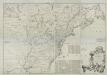
A map of the British and French dominions in North America : with the roads, distances, limits, and extent of the settlements, humbly inscribed to the Right Honourable the Earl of Halifax, and the other Right Honourable the Lords Commissioners for Trade
from Parts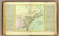
Possessions Francoises.
1 : 12500000 Clouet, J. B. L. (Jean-Baptiste Louis), b. 1730
A general map of North America : from the latest observations / J. Lodge sculp.
from The Constitutions of the several independent states of America; the Declaration of independence; the Articles of confederation between the said states; the treaties between His Most Christian Majesty and the United States of America. With an appendix, containing an authentic copy of the treaty concluded between Their High Mightinesses the States-General and the United States of America, and the provisional treaty. Pub. by order of Congress. Philadelphia printed. London reprinted, with an advertisement by J.L. de Lolme.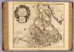
Canada, Nouvelle France.
1 : 9000000 L'Isle, Guillaume de, 1675-1726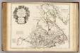
Canada, Nouvelle France.
1 : 9000000 L'Isle, Guillaume de, 1675-1726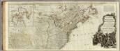
A new map of North America, with the West India Islands (northern section).
1 : 5300000 Pownall, Thomas
Depths and temperatures observed in the western part of the North Atlantic Ocean
1 : 7000000 United States Coast Survey U.S. Coast Survey
North America.
1 : 6500000 Jefferys, Thomas
Carte des Possessions Angloises & Françoises du Continent de l'Amerique Septentrionale
1 : 6900000 Mollova mapová sbírka Gosse, Pierre