Maps of United States

United States of America.
from Charts and maps
United States / drawn & engraved by J. Rapkin ; illustrations by J. Marchant & engraved by J. Rogers.
from Whole

Map of the United States and Texas / engraved by C. Copley, New York.
from Whole
United States.
from Whole
[Vereinigte Staaten von Nord-America und Canada]
Schul-Atlas über alle Theile der Erde nach dem neuesten Zustande, und über das Weltgebäude Stieler, Adolf bei Justus Perthes
Map of the United States : drawn from the most approved surveys.
from Whole
Etats Unis.
1 : 10000000 Vivien St Martin, L.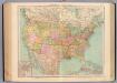
127-28. Stati Uniti.
1 : 10000000 Touring club italiano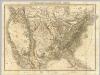
Die Vereinigten Staaten von Nord-America.
1 : 8000000 Bromme, Traugott
The course of the River St. Laurence : from Lake Ontario, to Manicouagan Point ; United States of America.
from St. Lawrence River

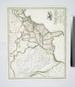
United States or Fredon / H.G. Spafford, del. ; G. Fairman sc.
from General geography, and rudiments of useful knowledge. In nine sections ... Illustrated with an elegant improved plate of the solar system ... a map of the world ... of the United States ... and several engravings on wood. Digested on a new plan, and designed for the use of schools. By H. G. Spafford.
Composite: Vereinigte Staaten v. Nordamerika.
1 : 8000000 Berghaus, Heinrich; Flemming, Carl; Sohr, Karl
194-195. United States of America. The World Atlas.
1 : 10000000 USSR (Union of Soviet Socialist Republics).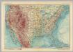
United States of America. Pergamon World Atlas.
1 : 10000000 Polish Army Topography Service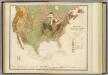
Geol. map U.S.
1 : 10000000 Rogers, Henry Darwin
United States of America.
1 : 22000000 Colton, G.W.
Accurata delineatio celeberrimae regionis Ludovicianae vel Gallice Louisiane ot. Canadae et Floridae adpellatione in Septemtrionali America: descriptae quae hodie nomine fluminis Mississippi vel St. Louis per colonias et navigationes Gallorum ob immensas opes et adfluentiam magis magisque inclarescit ex fide digniss.
from John H. Levine Collection s.n.: [Augspurg]; Rogg, Gottfried; Seutter, Matthaeus,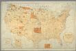
Map showing the location of the Indian reservations within the limits of the United States and territories / compiled from official and other authentic sources, under the direction of the Hon. John D.C. Atkins, Commissioner of Indian Affairs ; Paul Brodi
from Whole
A map of the United States including Louisiana / by Wm. Darby ; engraved by Jas. D. Stout.
from Whole
United States / Geo. Boynton, sc., Boston.
from Whole
United States of America / engrav'd by J. Warr Jr., No. 110 Walnut St. Philada.
from Whole J. Warr Jr.,
Vereinigte Staaten von Nord-America
Hand-Atlas über alle Theile der Erde nach dem neuesten Zustande und über das Weltgebäude Stieler, Adolf bei Justus Perthes
American Continent: United States, British Possessons, West Indies, Mexico, Central America
1 : 4435200 Rosa, R.
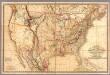
Map of the United States of America with its territories & districts : including also a part of upper & lower Canada and Mexico.
from Whole
Accurata delineatio celeberrimae Regionis Ludovicianae vel Gallice Louisiane
1 : 12000000 Rogg, Gottfried, 1669-1742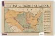
The battle fronts of Europe
1 : 2500000 Map of battle fronts drawn to scale upon a map of the United States showing relative distances of fronts. Roberts & Leete. London : Stanford's Geographical Establishment
Verein-Staaten Von Nord-America, Mexico, Yucatan U. A.
1 : 13400000 Stulpnagel, F.v.