Maps of United States

A map of the United States : compiled chiefly from the state maps and other authentic information / by Saml. Lewis, 1809 ; W. [Harrison?] Junr., sculpt.
from Carey's American atlas.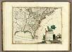
Canada, Le Colonie Inglesi Con La Luigiana, e Florida.
1 : 10000000 Zatta, Antonio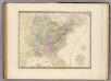
Etats-Unis d'Amerique.
1 : 8000000 Andriveau-Goujon, J.
Map of the United States of North America / compiled from the latest and most authentic information by David H. Vance ; engraved by J.H. Young.
from Whole
The United States of America, showing the boundaries fixed in 1782, five years before the ratification of the Constitution : from a contemporary copy of Benjamin Franklin's red-line map identified in Spain by the Library of Congress at Washington.
1 : 6860480 Facsimile of map published in Paris by Le Rouge and dated 1777. Relief shown pictorially. Inset letters of Aranda and Franklin printed in facsimile reflect the official use of the map in establishing United States boundaries. "Reprinted 1838 by U.S. Geological Survey." Includes text and inset: Nouvelle carte de la Baye dHudson et de Labrador selon las dernieres cartes levées sur les lieux. "This map is one of a series of similar colored maps, depicting the 13 original states from New Hampshire to Georgia at the time of the formation of the Constitution." John, Mitchel, 1711-1768 Washington, D.C. : United States Constitution Sesquicentennial Commission, [Washington, D.C.] : U.S. Geological Survey
The United States of North America, with the British & Spanish territories according to the treaty / engrav'd by Wm. Faden.
from Whole William Faden,
United States or Fredon / H.G. Spafford, del. ; G. Fairman sc.
from General geography, and rudiments of useful knowledge. In nine sections ... Illustrated with an elegant improved plate of the solar system ... a map of the world ... of the United States ... and several engravings on wood. Digested on a new plan, and designed for the use of schools. By H. G. Spafford.

United States
A new general atlas of modern geography, consisting of a complete collection of maps of the four quarters of the globe Wyld, James James Wyld
Map of the United States and Canada : shewing Captn. Hall's route through those countries in 1827 & 1828 / engraved on steel by W.H. Lizars.
from Parts
Map of the United States and Texas / engraved by C. Copley, New York.
from Whole
The United States of America / B. Tanner, sculpt.
from The American war, from 1775 to 1783, with plans / by Charles Smith.
Vereinigte Staaten in Nord America: nach den besten Hülfsmittel verfast / Wien bey T. Mollo.; Lorenz Rieder sc.
from Charts and maps Wien bey; T. Mollo. Lorenz Rieder,
Vereinigte Staaten von Amerika
1 : 6000000 Filipíny Carl Flemming
Karte der Vereinigten Staaten von Nordamerika
1 : 3000000 Aljaška Handtke, Friedrich Carl Flemming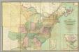
Map of the United States.
1 : 2000000 Walker, John & Alexander
A general map of North America : from the latest observations / J. Lodge sculp.
from The Constitutions of the several independent states of America; the Declaration of independence; the Articles of confederation between the said states; the treaties between His Most Christian Majesty and the United States of America. With an appendix, containing an authentic copy of the treaty concluded between Their High Mightinesses the States-General and the United States of America, and the provisional treaty. Pub. by order of Congress. Philadelphia printed. London reprinted, with an advertisement by J.L. de Lolme.
A map of Florida and ye Great Lakes of Canada / by Robt. Morden.
from Atlas terrestris / by Robt. Morden.
Ètats-Unis de l'Amérique septentrionale avec les Isles Royale, de Terre Neuve, de St. Jean, l'Acadie &c.
from Charts and maps Chez Delamarche, géogr.: Paris; Delamarche, Charles François,
Ètats-Unis de l'Amérique septentrionale avec les Isles Royale, de Terre Neuve, de St. Jean, l'Acadie &c.
from John H. Levine Collection Chez Delamarche, géogr.: Paris; Delamarche, Charles François,
Map Of The United States Of North America.
1 : 2154240 Vance, David H.
New Map of the United States. (Proposal to publish.)
Vance, David H.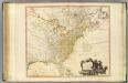
United States of North America.
1 : 6350000 Faden, William, 1750?-1836
Mitchell's map of the United States : showing the principal travelling turnpike and common roads, on which are given the distances in miles from one place to another, also the courses of the canals & rail roads throughout the country, carefully compi
from Whole
A new and correct map of the United States ... Upper & Lower Canada ... &c
1 : 4100000 Lewis, Samuel
A Map of Carolana and of the River Meschacebe &c.
from Charts and maps Printed for B. Cowse?: [London],
Fredonia or the United States of North-America : including also Cabotia, or the Canadian provinces; the Western Territory to the Pacific Ocean; and the northern part of the Mexican States
1 : 5700000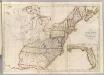
Map of the United States.
1 : 3660000 Carey, Mathew
Map of the United States.
1 : 3675000 Carey, Mathew
![A map of the United States : compiled chiefly from the state maps and other authentic information / by Saml. Lewis, 1809 ; W. [Harrison?] Junr., sculpt.](https://images-2.georeferencer.com/images/iiif/865071795818/full/,300/0/native.jpg)

