Maps of Canada

Amerique septentrionale / par N. Sanson d'Abbeville, geog. du Roy; A. Peyrounin, sculp.
from Whole N. Sanson; A. Peyrounin,
Amerique septentrionale divisée en ses principales parties.
from John H. Levine Collection [s.n.]: A Paris; Jaillot, Charles Hubert Alexis,
Amerique septentrionale divisée en ses principales parties.
from John H. Levine Collection [s.n.]: A Paris; Jaillot, Charles Hubert Alexis,
Amerique septentrionale divisée en ses principales parties: ou sont distingués les vns des autres les estats suivant qu'ils appartiennent presentemet aux François, Castillans, Anglois, Suedois, Danois, Hollandois / tirée des relations de toutes ces nations par le Sr. Sanson, geographe ordinaire du Roy; Cordier, sculps?
from Whole Sanson,
Amerique septentrionale divisée en ses principales parties: ou sont distingués les vns des autres les estats suivant qu'ils appartiennent presenteme[n]t aux François, Castillans, Anglois, Suedois, Danois, Hollandois, tirée des relations de toutes ces nations / par le Sr. Sanson, geographe ordinaire du Roy.
from John H. Levine Collection Sanson,
An accurate map of North America from the latest improvements, and regulated by astronomical observations.
from Whole s.n.: [London?]; Rollos, G.,
Amerique septentrionale divisée en ses principales parties.
from Whole Chés Ian Bt. Elwe: Amsterdam; Elwe, Jan Barend,
Amerique septentrionale divisée en ses principales parties.
from Whole Chés Ian Bt. Elwe: Amsterdam; Elwe, Jan Barend,
North America divided into its principall parts where are distinguished the severall states which belong to the English, Spanish, and French / described by Sanson; corrected and amended by William Berry.; [A collection of maps of the world] / [described by Sanson; corrected and amended by William Berry.]
from Collection of maps, 1680-1690 Berry, William; Morden, Robert; Petty, William, Sir; Sanson, Nicolas; Slaney, Edward,
An accurate map of North America: drawn from the best modern maps and charts, and regulated by astron'l. observatns. / by Eman. Bowen, geog'r. to His Majesty, 1747.; An account of the European settlements in America: in six parts ... Each part contains an accurate description of the settlements in it, their extent, climate, productions, trade, genius and disposition of their inhabitants; the interests of the several powers of Europe with respect to those settlements, and their political and commercial views with regard to each other.
from An account of the European settlements in America : in six parts ... Each part contains an accurate description of the settlements in it, their extent, climate, productions, trade, genius and disposition of their inhabitants ; the interests of the several powers of Europe with respect to those settlements, and their political and commercial views with regard to each other. Burke, Edmund; Burke, William; Dodsley, James,
A new mapp of America Septentrionale / designed by Mousieur Sanson, geographer to the French King and rendred into English, and illustrated by Richard Blome by His Majesties especiall command; Francis Lamb sculp.
from Charts and maps Mousieur Sanson; Richard Blome,
Ueberfahrts-Karte.
1 : 30000000 Radefeld, Carl Christian Franz, 1788-1874
Carte nouvelle de l'Amerique angloise : contenant la Virginie, Mary-Land, Caroline, Pensylvania, Nouvelle Iorck, N. Iarsey, N. France, et les terres nouvellement decouerte dressé sur les relations les plus nouvelles / par le Sieur S.
from Charts and maps
Physikalische Wandkarte der Erde in Merkartor's Projection
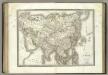
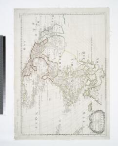
L'Asie.
1 : 24000000 Lapie, M. (Pierre), 1779-1850
Asia.
1 : 31680000 Colton, G.W.
Severní Amerika
1 : 46500000 Severní Amerika Merklas, Václav
Amerique septentrionale divisée en ses principale parties.
from Whole Ottens, R. (Reinier); Jaillot, Charles Hubert Alexis,
Chart Shewing (sic) the Communication between Europe, North America, and the Pacific.
1 : 14500000 Black, Adam & Charles
Map of North America Including All The Recent Geographical Discoveries. 1826.
1 : 17424000 Finley, Anthony
L'Amerique septentrionale
1 : 18900000 Severní Amerika Jaillot, Alexis-Hubert H. Iaillot
AMERIQUE SEPTENTRIONALE
1 : 18900000 Severní Amerika Jaillot, Alexis-Hubert H. Iaillot
Ueberfahrts-Karte
Grosser Hand-Atlas über alle Theile der Erde in 170 Karten Meyer, J. Verlag des Bibliographischen Instituts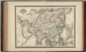
Asia.
1 : 25000000 Johnson, A.J.
L'Amerique Septentrionale.
1 : 19000000 Lapie, M. (Pierre), 1779-1850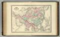
Asia.
1 : 25000000 Johnson, A.J.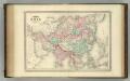
Asia.
1 : 25000000 Johnson, A.J.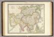
Asia.
1 : 27500000 Teesdale, Henry