Maps of Great Lakes

A new and general map of the middle dominions belonging to the United States of America: viz. Virginia, Maryland, the Delaware-counties, Pennsylvania, New Jersey &c. with the addition of New York, & of the greatest part of New England &c as also of the bordering parts of the British possessions in Canada.
from Parts Published by Laurie & Whittle, No. 53 Fleet Street ...: London; Robert Laurie and James Whittle,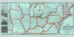
Lake Shore and Michigan So. Railway.
1 : 3431200 Lake Shore & Michigan Southern Railway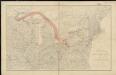
Distribution of the iron ores mined in the Lake Superior Region in year 1902
1 : 2500000 Birkinbine, John Geological Survey (U.S.)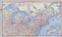
Shell Highway Map Northeastern Section of the United States.
1 : 3231360 Shell Oil Company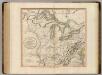
Western Terr., Kentucky, Pennsylvania, etc.
1 : 3300000 Cary, John, ca. 1754-1835
This map of Upper and Lower Canada and United States.
1 : 3700000 Tardieu, P.F.
Map New York Central Lines.
1 : 4200000 New York Central Railroad Company
Skeleton map of the rail-roads between Cape Canso and St. Louis

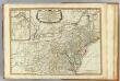
A map of the north west parts of the United States of America
1 : 3000000 Fitch, John, 1743-1798 engraved & printed by the author
Map of the northern parts of the United States of America / by Abraham Bradley.
from Parts Abraham Bradley,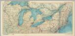
United States of America - Great Lakes. Pergamon World Atlas.
1 : 2500000 Polish Army Topography Service
[Die Vereinigten Staaten von Nord-Amerika, Blatt 3]
Handatlas über alle Theile der Erde und über das Weltgebäude Stieler, Adolf Justus Perthes
[Die Vereinigten Staaten von Amerika in 6 Blättern, Blatt 3]
Adolf Stieler's Handatlas über alle Theile der Erde und über das Weltgebäude Stieler, Adolf Justus Perthes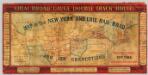
Map of the New York and Erie Rail Road and its connections.
1 : 3370000 New York And Erie Railway Company
Bowles's new one-sheet map of the independent states of Virginia, Maryland, Delaware, Pensylvania, New Jersey, New York, Connecticut, Rhode Island, &c. : comprehending also the habitations & hunting countries of the confederate Indians.
from Bowles's universal atlas. ...
Vereinigte Staaten Von Nord-Amerika In 6 Blattern, Bl. 3.
1 : 3700000 Petermann, A.
PARTIE OCCIDENTALE de la NOUVELLE FRANCE ou du CANADA
1 : 3600000 Velká kanadská jezera (Kanada a Spojené státy americké) Bellin, Jacques-Nicolas par le Heritiers de Homan
PARTIE OCCIDENTALE de la NOUVELLE FRANCE ou du CANADA
1 : 3600000 Velká kanadská jezera (Kanada a Spojené státy americké) Bellin, Jacques-Nicolas par les Heritiers de Homan
PARTIE OCCIDENTALE de la NOUVELLE FRANCE ou du CANADA
1 : 3600000 Velká kanadská jezera (Kanada a Spojené státy americké) Bellin, Jacques-Nicolas par les Heritiers de Homan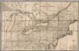
Map of the Canadas.
1 : 1267200 Taylor, David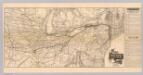
Map N.Y. Central & Hudson R. RR.
1 : 3104600 New York Central and Hudson River Railroad Company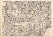
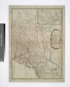
A Map of the British Empire in America. (Sheet 6).
1 : 2000000 Popple, Henry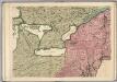
A Map of the British Empire in America. (Sheet 6).
1 : 2000000 Popple, Henry
Canada, Louisiane et Terres Angloises. (Northwest section)
1 : 2900000 Anville, Jean Baptiste Bourguignon d, 1697-1782
Vereinigte Staaten von Nord-Amerika in 6 blattern, bl. 3
Middle dominions U.S.
1 : 2200000 Robert Laurie & James Whittle
Nordoststaaten der Nordamerikanischen Union
1 : 3000000 New York (New York) Mielisch, H. Umbreit, E.

Canada West (Upper).
1 : 2000000 Tanner, Henry S.