Maps of United States

Map of the United States / by J.H. Young ; engraved by J.H. Young, D. Haines & F. Dankworth.
from Whole
United States or Fredon / H.G. Spafford, del. ; G. Fairman sc.
from General geography, and rudiments of useful knowledge. In nine sections ... Illustrated with an elegant improved plate of the solar system ... a map of the world ... of the United States ... and several engravings on wood. Digested on a new plan, and designed for the use of schools. By H. G. Spafford.
Wyld's Military Map Of The United States.
1 : 4500000 Wyld, James, 1812-1887
United States.
from Whole
A Map of Carolana and of the River Meschacebe &c.
from Charts and maps Printed for B. Cowse?: [London],
United States of America.
from Charts and maps
Östliches Nordamerica
Neuer Handatlas über alle Theile der Erde Kiepert, Heinrich Verlag von Dietrich Reimer
Map of the United States and Canada : shewing Captn. Hall's route through those countries in 1827 & 1828 / engraved on steel by W.H. Lizars.
from Parts

A map of the United States : compiled chiefly from the state maps and other authentic information / by Saml. Lewis, 1809 ; W. [Harrison?] Junr., sculpt.
from Carey's American atlas.
U.S. Eastern.
1 : 8870400 Letts, Son & Co.
United States / drawn & engraved by J. Rapkin ; illustrations by J. Marchant & engraved by J. Rogers.
from Whole
Map of the United States and Texas / engraved by C. Copley, New York.
from Whole
Cruchley's New Map of the United States (East) with Upper and Lower Canada
Cruchley's New Map of the United States (East) with Upper and Lower Canada. Dated May 1861, Cruchley’s New Map of the United States (East) with Upper and Lower Canada highlights the seceded Confederates states in yellow, the Union in green and the Canadian border in red. Delaware, Maryland and Kentucky are highlighted in yellow despite the fact that they remained within the Union. These Border States, especially Kentucky, witnessed internal civil wars as the states divided over secession. G.F. Cruchley was a London-based ‘map publisher and globe manufacturer’. G.F. Cruchley
Carte des Etats-Unis

Etats-Unis, Canada, Floride.
1 : 13500000 Delamarche, Charles Francois; Lattre, Jean
United States.
1 : 11800000 Darton, William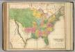
United States of America.
1 : 7900000 Lavoisne, M.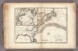
Gulf-Stream.
1 : 15000000 Vincent
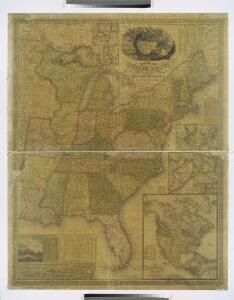
Wyld's military map of the United States, the northern states, and the southern Confederate states, with the forts, harbours, arsenals, and military positions

The United States of America, showing the boundaries fixed in 1782, five years before the ratification of the Constitution : from a contemporary copy of Benjamin Franklin's red-line map identified in Spain by the Library of Congress at Washington.
1 : 6860480 Facsimile of map published in Paris by Le Rouge and dated 1777. Relief shown pictorially. Inset letters of Aranda and Franklin printed in facsimile reflect the official use of the map in establishing United States boundaries. "Reprinted 1838 by U.S. Geological Survey." Includes text and inset: Nouvelle carte de la Baye dHudson et de Labrador selon las dernieres cartes levées sur les lieux. "This map is one of a series of similar colored maps, depicting the 13 original states from New Hampshire to Georgia at the time of the formation of the Constitution." John, Mitchel, 1711-1768 Washington, D.C. : United States Constitution Sesquicentennial Commission, [Washington, D.C.] : U.S. Geological Survey
United States of America / engrav'd by J. Warr Jr., No. 110 Walnut St. Philada.
from Whole J. Warr Jr.,
Vereinigten Staaten von Nord America
Neuester Schul-Atlas Walch, Johann im Verlag bei Joh. Walch
United States of America.
1 : 7900000 Lavoisne, M.
Ètats-Unis de l'Amérique septentrionale avec les Isles Royale, de Terre Neuve, de St. Jean, l'Acadie &c.
from Charts and maps Chez Delamarche, géogr.: Paris; Delamarche, Charles François,
Ètats-Unis de l'Amérique septentrionale avec les Isles Royale, de Terre Neuve, de St. Jean, l'Acadie &c.
from John H. Levine Collection Chez Delamarche, géogr.: Paris; Delamarche, Charles François,
Etats-Unis d'Amerique.
1 : 8000000 Buchon, J. A. C.; Carey, H. C.; Lea, I.
Map of the United States : drawn from the most approved surveys.
from Whole
Map Of The United States
1 : 2300000 Vance, David H.