Maps of Hudson County

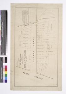
Map of property in the 2nd ward of the city of New York belonging to Timothy Wiggin Esq. / surveyed Edwin Smith, city surveyor, New York, November 1849.
from Manhattan
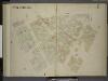
Plate 4, Part of Section 1: [Bounded by William Street, Ann Street, Gold Street, Beekman Street, Cliff Street, Dover Street, Cherry Street, Roosevelt Street, South Street, Pine Street, Pearl Street and Cedar Street.]
from Atlas of the city of New York, borough of Manhattan. From actual surveys and official plans / by George W. and Walter S. Bromley.
[Plate 4: Bounded by William Street, Ann Street, Gold Street, Beekman Street, Cliff Street, Dover Street, Cherry Street, Greenwich Street, Roosevelt Street, South Street, Pine Street, Pearl Street, and Cedar Street.]
from Atlas of the borough of Manhattan, city of New York.
[Plate 5: Map bounded by Frankfort Street, Franklin Square, Dover Street, South Street, Maiden Lane, Gold Street]
from Maps of the city of New York.
[Plate 5: Map bounded by Gold Street, Frankfort Street, Dover Street, South Street, Maiden Lane; Including Riders Alley, Jacob Street, Cliff Street, Pearl Street, Water Street, Front Street, Fletcher Street, Platt Street, John Street, Burling
from Maps of the city of New-York.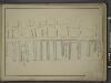
[Map bounded by Front St, Peck Slip, Peck Slip Ferry, Pier - Line 13-26; Including Gouverneurs Lane, Jones Lane, Wall St, Wall St Ferry, Pine St, Depeyster St, Maiden Lane, Fletcher St, Burling Slip, Fulton St, Fulton Ferry, Beekman St]
from Maps of the wharves & piers from the Battery to 61st street on the Hudson river and from the Battery to 41st street on the East river, New York. Surveyed by I.C. Buckhout, city surveyor.
[Plate 5: Map bounded by Gold Street, Ferry Street, Peck Slip, South Street, Maiden Lane.]
from Maps of the city of New York / surveyed under directions of insurance companies of said city.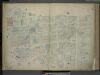
[Plate 4: Map bounded by Maiden Lane, South Street, Old Slip, Hanover Square, Exchange Place, Broad Street, Nassau Street; Including Liberty Street, Cedar Street, Depeyster Street, Pine Street, Wall Street, Hanover Street, Jone's Lane, Gouver
from Maps of the city of New-York.
[Plate 4: Map bounded by Maiden Lane, South Street, Old Slip, William Street, Exchange Place, Broad Street, Nassau Street]
from Maps of the city of New York.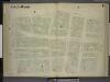
[1st & 2nd Wards. Plate G: Map bounded by Platt Street, Burling Slip, South Street, Wall Street, William Street; Including Maiden Lane, Fletcher Street, Liberty Street, Cedar Street, Depeyster Street, Pine Street, Gold Street, Pearl Str
from Maps of the city of New York.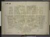
[2nd Ward. Plate: I Map bounded by William Street, Beekman Street, Gold Street, Ferry Street, Cliff Street, Pearl Street, Platt Street; Including Riders Alley, Cliff Street, John Street, Fulton Street]
from Maps of the city of New York.
[Plate 4: Map bounded by Liberty Street, Maiden Lane, South Street, Old Slip, William Street, Exchange Place, Broad Street, Nassau Street
from Maps of the city of New York / surveyed under directions of insurance companies of said city.
Manhattan, V. 1, Plate No. 5 south half [Map bounded by Gold St., Beekman St., South St., Maiden Lane]
From Atlas 107. Vol. 1, 1894.
Manhattan, V. 1, Plate No. 6 south half [Map bounded by Broadway, Fulton St., Gold St., Liberty St.]
From Atlas 107. Vol. 1, 1894.
Manhattan, V. 1, Plate No. 4 west half [Map bounded by Maidey Lane, Pearl St., Exchange Pl., Broad St.]
From Atlas 107. Vol. 1, 1894.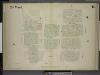
[2nd Ward. Plate H: Map bounded by Pearl Street, Beekman Street, Cliff Street, Ferry Street, Peck Slip, South Street, Burling Street; Including Water Street, Front Street, Fulton Street]
from Maps of the city of New York.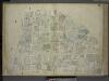
[Plate 6: Map bounded by Broadway, Park Row, Frankfort Street, Gold Street, Maiden Lane; Including Nassau Street, Theater Alley, Dutch Street, William Street, Platt Street, John Street, Fulton Street, Ann Street, Beekman Street, Spruce
from Maps of the city of New-York.
[Plate 6: Map bounded by Broadway, Park Row, Spruce Street, Gold Street, Liberty Street]
from Maps of the city of New York / surveyed under directions of insurance companies of said city.
Manhattan, V. 1, Plate No. 5 [Map bounded by Gold St., Dover St., Frankfort St., South St., Fulton St.]
From Atlas 107. Vol. 1, 1894.
[Plate 6: Map bounded by City Hall Square, Frankfort Street, Gold Street, Maiden Lane, Broadway, Park Row]
from Maps of the city of New York.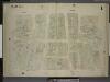
[2nd Ward. Plate 1: Map bounded by Broadway, Parks Row, Beekman Street, William Street, Liberty Street; Including Nassau Street, Theater Alley, Dutch Street, Maiden Lane, John Street, Fulton Street, Ann Street]
from Maps of the city of New York.
Manhattan, V. 1, Plate No. 3 [Map bounded by Dey St., Nassau St., Rector St., Trinity Pl., Church St.]
From Atlas 107. Vol. 1, 1894.
Manhattan, V. 1, Plate No. 4 [Map bounded by Maiden Lane, East River, Old Slip, Pearl St.]
From Atlas 107. Vol. 1, 1894.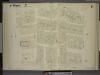
[1st Ward. Plate F: Map bounded by Liberty Street, William Street, Exchange Place, Trinity Place; Including Cedar Street, Thames Street, Pine Street, Wall Street, Temple Street, Broadway, Nassau Street, Broad Street]
from Maps of the city of New York.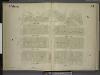
[1st Ward. Plate B: Map bounded by Stone Street, Beaver Street, Hanover Street, Wall Street, South Street, Coenties Slip; Including Pearl Street, Water Street, Front Street, Old Slip, Gouverneurs Lane, Jones Lane]
from Maps of the city of New York.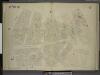
[1st Ward. Plate C: Map bounded by Exchange Place, William Street, Wall Street, Hanover Street, Beaver Street, Stone Street, Whitehall, Broadway; Including New Street, Broad Street, Marketfield Street, South William Street]
from Maps of the city of New York.
Manhattan, V. 1, Plate No. 6 [Map bounded by Broadway, Frankfort St., Gold St., Fulton St.]
From Atlas 107. Vol. 1, 1894.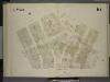
[4th Ward. Plate 10: Map bounded by Peck Slip, Pearl Street, Franklin Square, Pearl Street, Oak Street, Roosevelt Street, South Street; Including Dover Street, Front Street, Water Street, Cherry Street]
from Maps of the city of New York.
Plate 10: Map bounded by Nassau Street, Roosevelt Street, Oak Street, Oak Street, Pearl Street, Frankfort Street, Cliff Street, Ferry Street, Spruce Street
from Maps of the city of New York / surveyed under directions of insurance companies of said city.