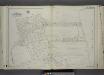
Maps of Middletown Township

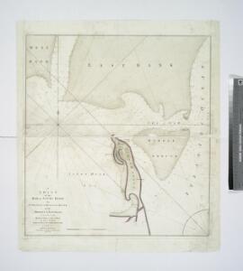
A chart of the bar of Sandy Hook : the entrance of Hudsons River in the province of New Jersey / survey'd in 1782, by Lieutt. Hills, of the 23d. Regt. and private draftsman to His Excellency the Commander in Chief.
from New York harbor
Sandy Hook
1 : 24000
Sandy Hook
1 : 24000
Sandy Hook
1 : 24000
Sandy Hook
1 : 24000
Sandy Hook
1 : 24000
Sandy Hook
1 : 24000
Use District Map Section No. 34; Use district map / City of New York, Board of Estimate and Apportionment.
from Use district map / City of New York, Board of Estimate and Apportionment. New York (N.Y.). Board of Estimate and Apportionment,
Area District Map Section No. 34; Area district map / City of New York, Board of Estimate and Apportionment.
from Area district map / City of New York, Board of Estimate and Apportionment. New York (N.Y.). Board of Estimate and Apportionment,
Height District Map Section No. 34
from Height district map / City of New York, Board of Estimate and Apportionment.
The Narrows
1 : 24000
Coney Island
1 : 24000
The Narrows
1 : 24000
Coney Island
1 : 24000
The Narrows
1 : 24000
Coney Island
1 : 24000
Coney Island
1 : 24000
Coney Island
1 : 24000
The Narrows
1 : 24000
The Narrows
1 : 24000
Coney Island
1 : 24000
The Narrows
1 : 24000
The Narrows
1 : 24000
The Narrows
1 : 24000
Coney Island
1 : 24000
The Narrows
1 : 24000
General map of the borough of Richmond (Staten Island) in the city of New York : showing in addition to the existing topographical features of the borough a tentative and preliminary plan for a street system of the same.
from Staten Island
Section 26
from Atlas of Staten Island, Richmond County, New York, from official records and surveys; compiled and drawn by F. W. Beers.
Part of Ward 4. [Map bound by New Dorp Lane, New Dorp Beach, Lower New York Bay, Old Mill Road (Coles Ave), Tysens Lane, South Side Boulevard]
from Atlas of the city of New York, borough of Richmond, Staten Island. From actual surveys and original plans, by George W. and Walter S. Bromley.