Maps of Appalachian Mountains

Carte du theatre de la guerre presente en Amerique / dressée d'après les nouvelles cartes anglaises par L. Denis, géographe et auteur du conducteur français.
from Charts and maps
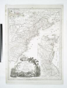
Carte nouvelle de l'Amerique angloise : contenant tout ce que les Anglois possedent sur le continent de l'Amerique septentrionale voir le Canada, la Nouvelle Ecosse ou Acadie, les treize provinces unies qui sont: les quatres colonies de la Nouvelle Angle
from Charts and maps
A new and exact map of the dominions of the King of Great Britain on ye continent of North America : containing Newfoundland, New Scotland, New England, New York, New Jersey, Pensilvania, Maryland, Virginia and Carolina / according to the newest and most
from The world described, or, A new and correct sett of maps : shewing the kingdoms and states in all the known parts of the earth, with the principal cities, and most considerable towns in the world ... / ... by Herman Moll, geographer ...
Carte nouvelle de l'Amerique angloise : contenant tout ce que les Anglois possedent sur le continent de l'Amerique septentrionale savoir le Canada, la Nouvelle Ecosse ou Acadie, les treize provinces unies qui sont: les quatres colonies de la Nouvelle Ang
from Charts and maps
Wyld's Military Map Of The United States.
1 : 4500000 Wyld, James, 1812-1887
A map of the British-plantations on the continent of America / Stephens fecit.
from Charts and maps Stephens fecit,
A new map of the British colonies in North America : shewing the seat of the present war, taken from the best surveys, compared with and improved from manuscripts of several noblemen and gentlemen / by John Andrews.
from Charts and maps
United States or Fredon / H.G. Spafford, del. ; G. Fairman sc.
from General geography, and rudiments of useful knowledge. In nine sections ... Illustrated with an elegant improved plate of the solar system ... a map of the world ... of the United States ... and several engravings on wood. Digested on a new plan, and designed for the use of schools. By H. G. Spafford.
United States.
from Whole
A Map of Carolana and of the River Meschacebe &c.
from Charts and maps Printed for B. Cowse?: [London],
Canada et Louisiane / par le Sr. le Rouge ingénieur géographe du Roy.
from Charts and maps
Possessions Francoises.
1 : 12500000 Clouet, J. B. L. (Jean-Baptiste Louis), b. 1730
A map of the United States : compiled chiefly from the state maps and other authentic information / by Saml. Lewis, 1809 ; W. [Harrison?] Junr., sculpt.
from Carey's American atlas.
North America 2.
1 : 4470000 Arrowsmith, Aaron
Carte de l'Amérique septentrionale, depuis la baye d'Hudson jusqu'au Mississipi: pour servir aux essais historiques et politiques sur la révolution de cette partie du monde.; Essais historiques et politiques sur les Anglo-Américains, par M. Hilliard d'Auberteuil ...
from Essais historiques et politiques sur les Anglo-Américains, par M. Hilliard d'Auberteuil ... Hilliard d'Auberteuil, Michel René,
A new map of North America from the latest discoveries / J. Spilsbury, sculp.
from Parts J. Spilsbury,
The United States of North America, with the British & Spanish territories according to the Treaty of 1784 / engrav'd by Wm. Faden, 1785.
from Charts and maps William Faden,
Carte des Etats-Unis

A new map of the English empire in America: viz. Virginia, Maryland, Carolina, New York, New Iarsey, New England, Pennsylvania, Newfoundland, New France &c. / revis'd by Ion. Senex, 1719; I. Harris, sculp.
from John H. Levine Collection John Senex; I. Harris,
A new map of the English empire in America: viz. Virginia, Maryland, Carolina, New York, New Iarsey, New England, Pennsylvania, Newfoundland, New France &c. / revis'd by Ion. Senex, 1719; I. Harris, sculp.
from Charts and maps John Senex; I. Harris,
The United States of America, showing the boundaries fixed in 1782, five years before the ratification of the Constitution : from a contemporary copy of Benjamin Franklin's red-line map identified in Spain by the Library of Congress at Washington.
1 : 6860480 Facsimile of map published in Paris by Le Rouge and dated 1777. Relief shown pictorially. Inset letters of Aranda and Franklin printed in facsimile reflect the official use of the map in establishing United States boundaries. "Reprinted 1838 by U.S. Geological Survey." Includes text and inset: Nouvelle carte de la Baye dHudson et de Labrador selon las dernieres cartes levées sur les lieux. "This map is one of a series of similar colored maps, depicting the 13 original states from New Hampshire to Georgia at the time of the formation of the Constitution." John, Mitchel, 1711-1768 Washington, D.C. : United States Constitution Sesquicentennial Commission, [Washington, D.C.] : U.S. Geological Survey
Carte nouvelle de l'Amerique Angloise
1 : 4400000 Spojené státy americké-oblast východní Lotter, Matthäus Albrecht par Matthieu Albert Lotter
Carte nouvelle de l'Amerique angloise contenant tout ce que les Anglois possedent sur le continent de l'Amerique Septentrionale
1 : 3800000 Spojené státy americké-oblast východní Lotter, Matthäus Albrecht Matthieu Albert Lotter
Canada, Le Colonie Inglesi Con La Luigiana, e Florida.
1 : 10000000 Zatta, Antonio
Map of the United States / by J.H. Young ; engraved by J.H. Young, D. Haines & F. Dankworth.
from Whole
Canada et Louisiane
Kanada Le Rouge, Georges-Louis le Rouge
Canada et Louisiane
1 : 5000000 par le Sr. Le Rouge A Paris : [Le Rouge], Rue des Augustins]
United States
A new general atlas of modern geography, consisting of a complete collection of maps of the four quarters of the globe Wyld, James James Wyld
U.S. Eastern.
1 : 8870400 Letts, Son & Co.