Maps of New Jersey

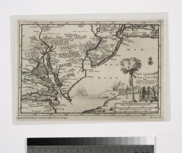
D'Engelze volkplanting in Virginie / door Iohan Smith bezogt en verder uytgeset; uytgevoerd te Leyden door Pieter vander Aa.
from Charts and maps Pieter vander Aa,
An exact map of New Jersey, Pensylvania, New York, Maryland & Virginia, from the latest surveys / J. Lodge, sculp.
from Parts John Lodge,
Map of the American Coast, from Lynhaven Bay to Narraganset Bay.
1 : 1267200 Melish, John
Map of the American Coast, from Lynhaven Bay to Narraganset Bay.
1 : 1267200 Melish, John
Carte de la Baye et Riviere de Délaware, contenant une éxacte et entiére description des rivages, criques, havres, sondes, bas-sonds, sables et gissements des marques ...
1 : 31000 France. Dépôt des cartes et plans de la marine France. Dépôt des cartes et plans de la marine
New Jersey.
from Whole
A New and accurate map of New Jersey : from the best authorities.
from Whole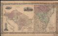
Colton's Georgetown and the city of Washington : the capital of the United States of America ; Colton's map showing part of Virginia, Maryland, Pennsylvania, New Jersey & New York
1 : 525000 Colton, J. H. Colton, J. H.
Map of the state of Maryland : laid down from an actual survey of all the principal waters, public roads, and divisions of the counties therein : describing the situation of the cities, towns, villages, houses of worship and other public buildings, fu...
From Maryland
A map of New Jersey, from the best authorities.
from The American geography; or, A view of the present situation of the United States of America: containing astronomical geography; geographical definitions, discovery, and general description ... By Jedidiah Morse, A.M.
New Iarsey / by John Seller.
from A new system of geography : designed in a most plain and easie method, for the better understanding that science : accommodated with new maps of all the empires, kingdoms, principalities, dukedoms, provinces, and countries in the whole world : with geographical tables, explaining the divisions in each map / by John Seller, late hydrographer to the King.
A new map of Virginia, Mary-land and the improved parts of Penn-sylvania & New Jersey / revised by I. Senex.
from Charts and maps I. Senex,
A map of the most inhabited part of Virginia containing the whole province of Maryland with part of Pensilvania, New Jersey and North Carolina / drawn by Joshua Fry & Peter Jefferson in 1751.
From Parts
Routes between New-York & Washington / drawn by I. Smith, geographer.
from Parts
Index to the Plates in Christopher Colles' Survey of the Roads.
1 : 2027520 Ristow, W. editor
A chart of Delaware Bay and River : containing a full and exact description of the shores, creeks, harbours, soundings, shoals, sands, and bearings of the most considerable land marks &c. &c. / faithfully coppied [sic] from that published at Philadelphia
from Parts
Virginia & Maryland.
1 : 1150000 Bowen, Emanuel
Virginia and Maryland.
1 : 1340000 Moll, Herman, d. 1732
A Map of the country round Philadelphia: including part of New Jersey, New York, Staten Island, & Long Island.; The Gentleman's magazine.
from The Gentleman's magazine. The Gentleman's magazine,
Delaware.
from Delaware
Delaware and Mary-Land / By David H. Burr, New-York; engd. & printed by Illman & Pilbrow.
from Parts David H. Burr; Illman & Pilbrow,
New Jersey.
from Supplement to the New York observer.
A map of New Jersey: from the best authorities.

New Jersey
1 : 505000 Sotzmann, D. F Bey Carl Ernst Bohn
A chart of Delaware Bay and River / from the original by Mr. Fisher of Philadelphia, 1776.
from Charts and maps
Composite: New Map Of The Peninsula Embracing Delaware And The Eastern Shores Of Maryland And Virginia
1 : 346480 MacCormac, Walter S.
The Province of New Jersey, divided into East and West, commonly called the Jerseys / engraved & published by Wm. Faden.
from Charts and maps
The Province of New Jersey, divided into East and West, commonly called the Jerseys / engraved & published by Wm. Faden, Charing Cross, December 1st, 1777 ; Croisey, sculpt.
from Whole
The State of New Jersey / compiled from the most accurate surveys / Martin sculpt.
from Whole