Maps of Delaware County
Map of the western part of the state of New York, 1823 / by D.H. Vance ; improved and enlarged to the east boundary of the state by J. Ogden Dey, 1824 ; engraved by Balch, Rawdon & Co.
from (A-Z)
A reference & distance map of the state of New York
1 : 1300000 Pierce, Justin J. Pierce
Post Route Map Of The State Of New York
1 : 380160 Nicholson, W. L.
Map of New York exhibiting the post offices, post roads, canals, rail roads &c. / By David H. Burr (late topographer to the Post Office), geographer to the House of Representatives of the U.S.
from Whole David H. Burr,
Map of the state of New York
1 : 2000000 Maverick, Samuel, 1789-1845 Andrus & Judd
State of New-York for Spafford's gazetteer / drawn by Mrs. B.C. Stafford; engd. by P. Maverick, Newark N.J.; A gazetteer of the state of New-York; carefully written from original and authentic materials, arranged on a new plan, in three parts. By Horatio Gates Spafford.
from A gazetteer of the state of New-York; carefully written from original and authentic materials, arranged on a new plan, in three parts. By Horatio Gates Spafford. Southwick, Henry Collins; Spafford, Horatio Gates,
New York.
1 : 1350000 Rand McNally and Company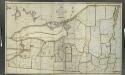
Map of the northern part of the state of New York / compiled from actual survey by Amos Lay, 1812.
from (A-Z)
The tourist's map of the state of New York: compiled from the latest authorities / engraved by V. Balch and S. Stiles.
from Whole V. Balch; S. Stiles,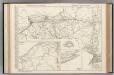
New York.
Rand McNally and Company
New York.
1 : 570000 Rand McNally and Company
New York (western and northern sections).
1 : 570000 Rand McNally and Company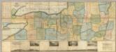
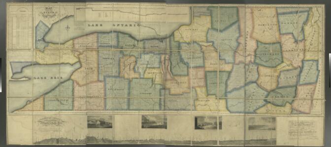
Map of the Western Part of the State Of New York.
1 : 330000 Vance, David H.
Map of the state of New York: compiled from the latest authorities.
from Whole Published by Thomas, Cowperthwait & Co.: Philadelphia; Thomas, Cowperthwait & Co.,
New-York / by David H. Burr; engraved & printed by S. Stiles & Co., N. York.
from Whole David H. Burr; S. Stiles & Co.,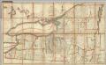
Northern Part of the State Of New York
1 : 443529 Lay, Amos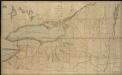
Map of the northern part of the state of New York
1 : 450000 Lay, Amos
State of New York.
1 : 1325000 Winterbotham, W.
Map of the county of Montgomery / by David H. Burr ; engd. by Rawdon, Clark & Co., Alby., & Rawdon, Wright & Co., N. York.
from An atlas of the state of New York : containing a map of the state and of the several counties. / Projected and drawn under the superintendence and direction of Simeon de Witt ... And also the physical geography of the State ...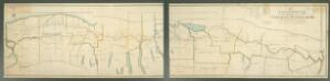
A new map and profile of the proposed canal from Lake Erie to Hudson River in the State of New York / contracted by direction of the Canal Commissioners from the maps of the engineers 1821.
from Erie Canal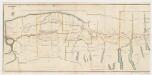
A new map and profile of the proposed canal from Lake Erie to Hudson River in the state of New York : Western sheet
1 : 253440 New York (State). Canal Commissioners W. A. Mercein, printer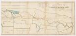
A new map and profile of the proposed canal from Lake Erie to Hudson River in the state of New York : Eastern sheet
1 : 253440 New York (State). Canal Commissioners W. A. Mercein, printer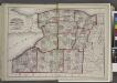
"Niagara, Erie, Chautauqua, Cattaraugus, Orleans, Genesee, Wyoming, Allegany, Monroe, and Livingston Counties"
from New topographical atlas and gazetteer of New York, comprising a topographical view of the several counties of the state, ... including ... map of the United States and territories ... Compiled from the latest astronomical observations, official surveys and records of the United States and territories ...
"Monroe, Livingston, Allegany, Wayne, Ontario, Steuben, Yates, Schuyler, Chemung, Seneca, Cayuga, Tompkins, Tioga, Onondaga, and Cortland Counties "
from New topographical atlas and gazetteer of New York, comprising a topographical view of the several counties of the state, ... including ... map of the United States and territories ... Compiled from the latest astronomical observations, official surveys and records of the United States and territories ...
"Oneida, Madison, Otsego, Fulton, Montgomery, Schenectady, Albany, Schoharie, Warren, Saratoga, Washington, and Rensselaer Counties"
from New topographical atlas and gazetteer of New York, comprising a topographical view of the several counties of the state, ... including ... map of the United States and territories ... Compiled from the latest astronomical observations, official surveys and records of the United States and territories ...
Map of the route of the proposed New York & Erie Railroad, as surveyed in 1834 / reduced from the plans as returned by Benjn. Wright, Civil Engineer ; D. R. Harrison, sc.
From Whole
New York.
1 : 614000 Hammond, C.S.
[Kaart], uit: Travellers' guide of the Hudson River
1 : 650000 Annotatie: Met beknopte beschrijving van de belangrijkste aan de Hudson gelegen plaatsen [S.l. : H.B. Kirkham]
Map of the state of New York.
from Whole