Maps of Virginia

A new map of Virginia : from the best authorities / by T. Kitchen, geogr.
from Virginia
Virginia.
from Supplement to the New York observer.
Operations in Virginia.
from Virginia
Virginia, Maryland, and Delaware / by H.S. Tanner.
from Charts and maps
The State of Virginia from the best authorities, 1796 / B. Tanner sculpt.
from Charts and maps
Virginia, Maryland, and Delaware / by H.S. Tanner.
from Parts
A new map of Virginia from the best authorities / by T. Kitchin, Geogr.
from London magazine, or, Gentleman's monthly intelligencer (1747)
Shell Sectional Map No. 3 - Middle Atlantic States.
1 : 1457280 Shell Oil Company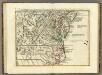
Il Maryland, il Jersey Meridionale, la Delaware.
1 : 2100000 Zatta, Antonio
The tourist's pocket map of the state of Virginia : exhibiting its internal improvements, roads, distances, &c. / by J.H. Young ; engraved by E. Yeager & F. Dankworth.
from Virginia
County map of Virginia and West Virginia.
from New general atlas.
Map of Virginia and Maryland, constructed from the latest authorities / J.H. Young sc.
from Parts
Lord Balitmore's own plan : proposed Maryland/Pennsylvania boundary.
from Maryland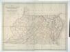
Map of Virginia, Maryland and Delaware exhibiting the post offices, post roads, canals, rail roads &c. / by David H. Burr, (Late topographer to the Post Office,) Geographer to the House of Representatives of the U.S.
from Parts David H. Burr,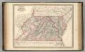
Virginia, Delaware, Maryland, and West Virginia.
1 : 1520000 Johnson, A.J.
Virginia, Delaware, Maryland, and West Virginia.
1 : 1520000 Johnson, A.J.
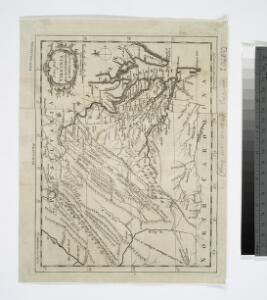
A New map of Virginia.; The history of the British plantations in America. With a chronological account of the most remarkable things, which happen'd to the first adventurers in their several discoveries of that new world. Part I. Containing The history of Virginia; with remarks on the trade and commerce of that colony ...
from The history of the British plantations in America. With a chronological account of the most remarkable things, which happen'd to the first adventurers in their several discoveries of that new world. Part I. Containing The history of Virginia; with remarks on the trade and commerce of that colony ... Keith, William, Sir; Society for the Encouragement of Learning,
A New map of Virginia.
from Cartographic materials from the Emmet Collection of Manuscripts Etc. Relating to American History. Printed at the expense of the Society for the Encouragement of Learning, by S. Richardson: [London],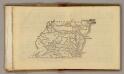
(Virginia, Maryland, Delaware)
1 : 4200000 Moore, M. B. (Marinda Branson), 1829-1864
County Map Of Virginia, and North Carolina.
1 : 2800000 Mitchell, Samuel Augustus
Il Maryland, il Jersey Meridionale, la Delaware e la parte Orientale della Virginia, e Carolina Settentrionale.
from Charts and maps A. (Antonio) Zatta:[Venezia],
E. United States 7.
1 : 1774080 Letts, Son & Co.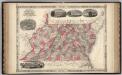
Virginia, Delaware, Maryland, and West Virginia.
1 : 1487000 Johnson, A.J.
Der Bundesdistrict Columbia, Virginien, Nord-Carolina, Maryland, u. Delaware.
1 : 3400000 Lange, Henry, 1821-1893.
A new and accurate map of the province of Virginia in North America.
from Virginia
Nova Virginiae Tabula [Karte], in: Novus atlas absolutissimus, Bd. 6, S. 207.
1 Karte aus Atlas Janssonius Offizin
Our Nation's Camp Ground.
1 : 2181787 Ensign, Bridgman & Fanning
A map of the most inhabited part of Virginia containing the whole province of Maryland with part of Pensilvania, New Jersey and North Carolina / drawn by Joshua Fry & Peter Jefferson in 1775.
from Charts and maps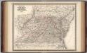
Virginia, Delaware, Maryland, and West Virginia.
1 : 1520000 Johnson, A.J.