Maps of Monmouth County

Map of the counties of New York, Queens, Kings, and Richmond.
from An atlas of the state of New York : containing a map of the state and of the several counties. / Projected and drawn under the superintendence and direction of Simeon de Witt ... And also the physical geography of the State ...
The country twenty five miles round New York
1 : 220000 ... W. Hawkes (successor to T. Kitchin), No. 59, Holborn Hill
Thirty miles round the city of New York
from Whole
Thirty three miles around the city of New-York
from Whole
Map of Long Island with the environs of New-York and the southern part of Connecticut / compiled from various surveys & documents by J. Calvin Smith ; engraved & printed by S. Stiles & Co., N. York.
From Long Island
Map of the counties of New York, Queens, Kings, and Richmond.
from An atlas of the state of New York : containing a map of the state and of the several counties / by David H. Burr.
40 miles around New York
1 : 158400 H.H. Lloyd & Co
Map of the country thirty miles round the city of New York
1 : 190080 Disturnell, John, 1801-1877 J. Disturnell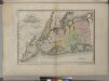
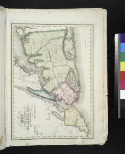
Map of the counties of New York, Queens, Kings, and Richmond.
from An atlas of the state of New York, designed for the use of engineers, containing a map of the state and of the several counties. / Projected and drawn ... under the superintendence and direction of Simeon de Witt.
Thirty miles round the city of New York
from Whole
Vingboons map of Manhattan, 1639 : a facsimile from the Library of Congress.
from Whole
General map of the city of New York, consisting of boroughs of Manhattan, Brooklyn, Bronx, Queens and Richmond : consolidated into one municipality by act of the legislature of the state of New York (Chapter 378 of the laws of 1897) : showing in addit...
From Whole
Map of the progress of His Majesty's armies in New York during the late campaign : illustrating the accounts publish'd in the London Gazette.
from Revolutionary War
Map of Long Island with the environs of New-York and the southern part of Connecticut / compiled from various surveys & documents by J. Calvin Smith ; engraved & printed by S. Stiles & Co., N. York.
From Long Island
A plan of the northern part of New Jersey : shewing the positions of the American and British armies after crossing the North River in 1776 / drawn by S. Lewis from surveys by order of Gen. Washington ; engrav'd by Fs. Shallus.
from Revolutionary War, 1775-1783
Westchester, Plate No. 1 [Map of Westchester County and Surroundings] / prepared under the direction of Joseph R. Bien, from general surveys and official records.
From Atlas of Westchester County, New York
[Map of the vicinity of City Hall, Brooklyn.]
From Brooklyn
A New and accurate map of the present seat of war in North America, comprehending New Jersey, Philadelphia, Pensylvania, New-York, &c.
1 : 550000
Map Of The Country Thirty Miles Round the City of New York.
1 : 190080 Eddy, John H.
Map ... Around The City Of New York.
1 : 205920 Colton, J. H.
United States--east coast, New York--New Jersey, New York Harbor / Coast Survey.
from New York harbor
Map of the Country Twenty Five Miles Round The City Of New-York.
1 : 300000 Greenleaf, Jeremiah
Map of the Country Twenty Five Miles Round The City Of New-York.
1 : 316800 Greenleaf, Jeremiah
Map of New-York and its vicinity /drawn by D.H. Burr, geographer ; engraved by S. Stiles, Sherman & Smith.
from New York harbor
Map of the Country Twenty Five Miles Round The City Of New-York.
1 : 211200 Burr, David H., 1803-1875
New York and vicinity [map]
1 : 24000 Geological Survey (U.S.) Geological Survey
Hammond's complete map of Brooklyn.
From Brooklyn
A draught of New York and Perthamboy Harbour.
from Charts and maps
Boroughs of Manhattan and Bronx, showing the electric service of the New York Edison Co.
From Manhattan