Maps of Adirondack Mountains

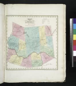
Map of the county of Montgomery / by David H. Burr ; engd. by Rawdon, Clark & Co., Alby., & Rawdon, Wright & Co., N. York.
from An atlas of the state of New York : containing a map of the state and of the several counties. / Projected and drawn under the superintendence and direction of Simeon de Witt ... And also the physical geography of the State ...
Shell Highway Map of New York (western portion).
1 : 792000 Shell Oil Company
New York.
1 : 570000 Rand McNally and Company
State of New York.
1 : 1325000 Winterbotham, W.
Map of the state of New York: compiled from the latest authorities.
from Whole Published by Thomas, Cowperthwait & Co.: Philadelphia; Thomas, Cowperthwait & Co.,
New-York / by David H. Burr; engraved & printed by S. Stiles & Co., N. York.
from Whole David H. Burr; S. Stiles & Co.,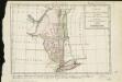
Carte de la Nouvelle York, y-compris les terres cédées du N. Hamp-Shire, sous le nom d'etat de Vermont
1 : 2500000 Hilliard d'Auberteuil, Michel René
Map of the state of New York / by Simeon De Witt, surveyor general; engraved by G. Fairman.
from Charts and maps Simeon De Witt; G. Fairman,
An Accurate map of New York in North America, from a late survey.
from John H. Levine Collection J. (John) Hinton: [London],
Northern Part of the State Of New York
1 : 443529 Lay, Amos
New York.
1 : 614000 Hammond, C.S.
Map of the northern part of the state of New York
1 : 450000 Lay, Amos
New York (eastern section).
1 : 570000 Rand McNally and Company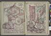
"Jefferson, Oswego, and Lewis Counties"
from New topographical atlas and gazetteer of New York, comprising a topographical view of the several counties of the state, ... including ... map of the United States and territories ... Compiled from the latest astronomical observations, official surveys and records of the United States and territories ...
Province de New-York : en 4 feuilles / par Montrésor.
from (A-Z)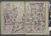
"Oneida, Madison, Otsego, Fulton, Montgomery, Schenectady, Albany, Schoharie, Warren, Saratoga, Washington, and Rensselaer Counties"
from New topographical atlas and gazetteer of New York, comprising a topographical view of the several counties of the state, ... including ... map of the United States and territories ... Compiled from the latest astronomical observations, official surveys and records of the United States and territories ...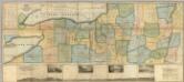
Map of the Western Part of the State Of New York.
1 : 330000 Vance, David H.
Hamilton County.
from Atlas of New York.
Map of the head waters of the rivers Susquehanna & Delaware embracing the early patents on the south side of the Mohawk River : from the original, drawn about the year 1790
1 : 260000 De Witt, Simeon, 1756-1834 Weed, Parsons & Co.
Map of the Adirondack wilderness
1 : 255000 Stoddard, Seneca Ray, 1844-1917 S.R. Stoddard
Map of the New York wilderness : to accompany Wallace's Descriptive guide to the Adirondacks
1 : 253440 Ely, William Watson G. W. & C. B. Colton & Co.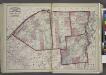
"St. Lawrence, Franklin, Clinton, and Essex"
from New topographical atlas and gazetteer of New York, comprising a topographical view of the several counties of the state, ... including ... map of the United States and territories ... Compiled from the latest astronomical observations, official surveys and records of the United States and territories ...
[Kaart], uit: Travellers' guide of the Hudson River
1 : 650000 Annotatie: Met beknopte beschrijving van de belangrijkste aan de Hudson gelegen plaatsen [S.l. : H.B. Kirkham]
Survey of the several routes for a rail road from Ogdensburgh to Lake Champlain : made in pursuance of an act of the State of New York, passed May 14th, 1840 / by Edw H. Brodhead, chief engineer ; J.H. Jackson, H. Thomas & V. Whitney, commissrs.
from (A-Z)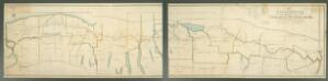
A new map and profile of the proposed canal from Lake Erie to Hudson River in the State of New York / contracted by direction of the Canal Commissioners from the maps of the engineers 1821.
from Erie Canal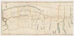
A new map and profile of the proposed canal from Lake Erie to Hudson River in the state of New York : Western sheet
1 : 253440 New York (State). Canal Commissioners W. A. Mercein, printer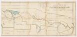
A new map and profile of the proposed canal from Lake Erie to Hudson River in the state of New York : Eastern sheet
1 : 253440 New York (State). Canal Commissioners W. A. Mercein, printer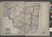
"Delaware, Sullivan, Greene, Ulster, Orange, Columbia, Dutchess, and Putman Counties"
from New topographical atlas and gazetteer of New York, comprising a topographical view of the several counties of the state, ... including ... map of the United States and territories ... Compiled from the latest astronomical observations, official surveys and records of the United States and territories ...
Watertown. [Township]
from New topographical atlas of Jefferson Co., New York : From actual surveys / by S.N. & D.G. Beers and assistants.