Maps of Long Island

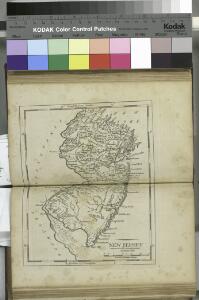
New Jersey / engraved by A. Doolittle, Newhaven.; Carey's American pocket atlas; containing nineteen maps... with a brief description of each state.
from Carey's American pocket atlas; containing nineteen maps... with a brief description of each state. Carey, Mathew; Sweitzer, Henry,
New Jersey / engraved by J.H. Young.
from Whole J. H. Young,
New Jersey / engraved by J.H. Young.
from Whole J. H. Young,
The Country twenty five miles round New York / drawn by a gentleman from that city ; J. Barber, sculp., Holborn Hill.
from Whole
A map of the state of New Jersey: with part of the adjoining states / compiled under the patronage of the Legislature of said state by Thomas Gordon; engraved by H.S. Tanner, assisted by E.B. Dawson & W. Allen.
from Whole Thomas Gordon; Henry S. Tanner; E.B. Dawson; W. Allen,
A New and accurate map of the present seat of war in North America: comprehending New Jersey, Philadelphia, Pensylvania, New-York, &c.
from Revolutionary War, 1775-1783 s.n.: [London],
A New and accurate map of the province of Pennsylvania in North America, from the best authorities.
from Whole Hinton, John,
A plan of New York Island, with part of Long Island, Staten Island & east New Jersey : with a particular description of the engagement on the woody heights of Long Island, between Flatbush and Brooklyn, on the 27th of August 1776 between His Majesty's fo
from Whole
Plate 5: Map of New York and vicinity, accompanying Atlas of New York and vicinity.
from Atlas of New York and vicinity : from actual surveys / by and under the direction of F. W. Beers, assisted by A. B. Prindle & others
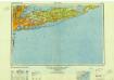
Map of Long Island with the environs of New-York and the southern part of Connecticut / compiled from various surveys & documents by J. Calvin Smith ; engraved & printed by S. Stiles & Co., N. York.
from Long Island
New York (City) & Vicinity.
1 : 400000 Asher & Adams
Map of the country thirty three miles around the city of New York / drawn by G.W. Colton ; engraved by J.M. Atwood, N.Y.
from Whole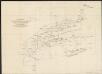
A diagram of the triangulation for the survey of the coast of the United States, made in 1817 and 1833, and the secondary triangles made in 1833 & 1834 in Connecticut & upon Long Island
1 : 412000 United States Coast Survey United States Coast Survey
New York & vicinity.
1 : 253440 Beers, F. W. (Frederick W.)
Westchester, Plate No. 1 [Map of Westchester County and Surroundings] / prepared under the direction of Joseph R. Bien, from general surveys and official records.
From Atlas of Westchester County, New York
Thirty three miles around the city of New-York
from Whole
Map of the progress of His Majesty's armies in New York during the late campaign : illustrating the accounts publish'd in the London Gazette.
from Revolutionary War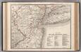
New York-Philadelphia District.
1 : 317000 Rand McNally and Company
Map of Long Island with the environs of New-York and the southern part of Connecticut / compiled from various surveys & documents by J. Calvin Smith ; engraved & printed by S. Stiles & Co., N. York.
From Long Island
Chief Engineer's Office. Board of Estimate and Apportionment. Index Map. Showing Location of the Sectional Plans of the City of New York.
from Height district map / City of New York, Board of Estimate and Apportionment.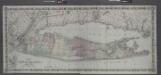
Map of Long Island and the southern part of Connecticut.
from Long Island
The country twenty five miles round New York
1 : 220000 ... W. Hawkes (successor to T. Kitchin), No. 59, Holborn Hill
Map of Long Island with the environs of New-York and the southern part of Connecticut / compiled from various surveys & documents by J. Calvin Smith ; engraved & printed by S. Stiles & Co., N. York.
From Long Island
Map of the counties of New York, Queens, Kings, and Richmond.
from An atlas of the state of New York : containing a map of the state and of the several counties. / Projected and drawn under the superintendence and direction of Simeon de Witt ... And also the physical geography of the State ...
Brooklyn land use policy
From The Borough
Thirty miles round the city of New York
from Whole
40 miles around New York
1 : 158400 H.H. Lloyd & Co
Thirty miles round the city of New York
from Whole
Map of the country thirty miles round the city of New York
1 : 190080 Disturnell, John, 1801-1877 J. Disturnell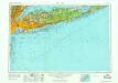
New York
1 : 250000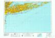
New York
1 : 250000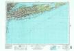
New York
1 : 250000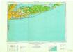
New York
1 : 250000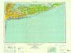
New York
1 : 250000
New York
1 : 250000
New York
1 : 250000
New York
1 : 250000
New York
1 : 250000