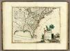
Maps of United States

United States or Fredon / H.G. Spafford, del. ; G. Fairman sc.
from General geography, and rudiments of useful knowledge. In nine sections ... Illustrated with an elegant improved plate of the solar system ... a map of the world ... of the United States ... and several engravings on wood. Digested on a new plan, and designed for the use of schools. By H. G. Spafford.
United States.
from Whole

United States of America.
from Charts and maps
Map of the United States and Canada : shewing Captn. Hall's route through those countries in 1827 & 1828 / engraved on steel by W.H. Lizars.
from Parts
Map of the United States and Texas / engraved by C. Copley, New York.
from Whole
United States / drawn & engraved by J. Rapkin ; illustrations by J. Marchant & engraved by J. Rogers.
from Whole
A general map of North America : from the latest observations / J. Lodge sculp.
from The Constitutions of the several independent states of America; the Declaration of independence; the Articles of confederation between the said states; the treaties between His Most Christian Majesty and the United States of America. With an appendix, containing an authentic copy of the treaty concluded between Their High Mightinesses the States-General and the United States of America, and the provisional treaty. Pub. by order of Congress. Philadelphia printed. London reprinted, with an advertisement by J.L. de Lolme.
Etats Unis.
1 : 10000000 Vivien St Martin, L.
Wyld's Military Map Of The United States.
1 : 4500000 Wyld, James, 1812-1887
Accurata delineatio celeberrimae Regionis Ludovicianae vel Gallice Louisiane
1 : 12000000 Rogg, Gottfried, 1669-1742
Accurata delineatio celeberrimae regionis Ludovicianae vel Gallice Louisiane ot. Canadae et Floridae adpellatione in Septemtrionali America: descriptae quae hodie nomine fluminis Mississippi vel St. Louis per colonias et navigationes Gallorum ob immensas opes et adfluentiam magis magisque inclarescit ex fide digniss.
from John H. Levine Collection s.n.: [Augspurg]; Rogg, Gottfried; Seutter, Matthaeus,
America Septentrionalis. A Map of the British Empire in America.
1 : 11000000 Popple, Henry
A map of the United States : compiled chiefly from the state maps and other authentic information / by Saml. Lewis, 1809 ; W. [Harrison?] Junr., sculpt.
from Carey's American atlas.
The course of the River St. Laurence : from Lake Ontario, to Manicouagan Point ; United States of America.
from St. Lawrence River
Map of the United States / by J.H. Young ; engraved by J.H. Young, D. Haines & F. Dankworth.
from Whole
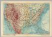
United States of America. Pergamon World Atlas.
1 : 10000000 Polish Army Topography Service
Map of the United States of North America / compiled from the latest and most authentic information by David H. Vance ; engraved by J.H. Young.
from Whole
[Vereinigte Staaten von Nord-America und Canada]
Schul-Atlas über alle Theile der Erde nach dem neuesten Zustande, und über das Weltgebäude Stieler, Adolf bei Justus Perthes
A new map of ye north parts of America claimed by France : under ye names of Louisiana, Mississipi, Canada & New France with the adjoyning territories of England & Spain / By H. Moll, geographer.
from Charts and maps
A Map of Carolana and of the River Meschacebe &c.
from Charts and maps Printed for B. Cowse?: [London],
Map of the United States : drawn from the most approved surveys.
from Whole
Ètats-Unis de l'Amérique septentrionale avec les Isles Royale, de Terre Neuve, de St. Jean, l'Acadie &c.
from Charts and maps Chez Delamarche, géogr.: Paris; Delamarche, Charles François,
Ètats-Unis de l'Amérique septentrionale avec les Isles Royale, de Terre Neuve, de St. Jean, l'Acadie &c.
from John H. Levine Collection Chez Delamarche, géogr.: Paris; Delamarche, Charles François,
Vereinigte Staaten Von Nordamerika

United States
A new general atlas of modern geography, consisting of a complete collection of maps of the four quarters of the globe Wyld, James James Wyld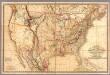
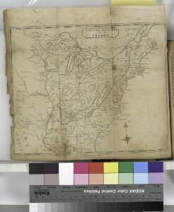
Fredonia Or The United States of North America.
1 : 570000 Laurie, Richard Holmes
A map of the British dominions in North America, according to the Treaty in 1763 / by Peter Bell, geographer, 1772.
from The history of the British dominions in North America: from the first discovery of that vast continent by Sebastian Cabot in 1497, to its present glorious establishment as confirmed by the late treaty of peace in 1763 ...