Maps of Appalachian Mountains

Nieuwe en nauwkeurige kaart van een gedeelte van Noord Amerika : behelzende Nieuw Engeland, New York, Pennsylvania, New Jersey, Connecticut, Rhode Island, een stuk van Virginia, Kanada en Halifax, ter opheldering der reizen van den Heer P. Kalm / C.J. de
from Reis door Noord Amerika, gedaan door den Heer Pieter Kalm ... Vercierd met koperen platen ...
Copy of a map attached to Govr. Colden's History of the Five Indian Natio[ns] : printed in London, A.D. MDCCXLVII.
from Parts
United States.
1 : 11800000 Bowen, Frances
Etats Unis Flle. N.E.
1 : 5000000 Vivien St Martin, L.
Nova tabula geographica complectens borealiorem Americae partem : in qua exacte delineatae sunt Canada sive Nova Francia, Nova Scotia, Nova Anglia, Novum Belgium, Pensylvania, Virginia, Carolina et Terra Nova : cum omnibus littorum pulvinorumque profundi
from John H. Levine Collection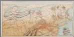
[Recto], uit: Reading railroad system and connections
Buffalo, N.Y. : The Matthews-Northrup Co.
Commercial Map, East of Chicago.
1 : 3950000 Rand McNally and Company
British American, English, Welsh, Swedish, Norwegian population 1870.
1 : 14300000 United States. Census Office; Walker, Francis Amasa, 1840-1897
[Die Vereinigten Staaten von Amerika in 6 Blättern, Blatt 3]
Adolf Stieler's Handatlas über alle Theile der Erde und über das Weltgebäude Stieler, Adolf Justus Perthes
[Die Vereinigten Staaten von Nord-Amerika, Blatt 3]
Handatlas über alle Theile der Erde und über das Weltgebäude Stieler, Adolf Justus Perthes
Distribution of the iron ores mined in the Lake Superior Region in year 1902
1 : 2500000 Birkinbine, John Geological Survey (U.S.)
An accurate map of the United States of America, with part of the surrounding provinces agreeable to the Treaty of Peace of 1783
1 : 1
New travelling and commercial map of the Canadas: from the Sault of St. Marie to the river Saguenay, and a large section of the United States of America / compiled from the latest surveys and most approved authorities ... by his obliged obedient humble servant David Taylor, R.N., March 1834; engraved by S. Stiles & Co.
from Parts David Taylor; S. Stiles & Co.,
Vereinigte Staaten Von Nord-Amerika In 6 Blattern, Bl. 3.
1 : 3700000 Petermann, A.
Composite: United States of Nth. America.
1 : 1584000 Tardieu, P.F.
United States of Nth. America.
1 : 1584000 Tardieu, P.F.
Map of the United States and British Provinces of Upper and Lower Canada.
1 : 1838000 Shelton, W.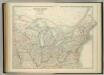
United States of North America (North East Sheet).
1 : 3984000 Johnston, W. & A.K.

(United States) East of Chicago.
1 : 3802000 Rand McNally and Company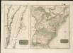
United States of America
American Atlantic ports N.
1 : 5000000 Philip, George
Der Nördliche Theil der Vereinigten Staaten von Nord America
Hand-Atlas über alle Theile der Erde nach dem neuesten Zustande und über das Weltgebäude Stieler, Adolf bei Justus Perthes
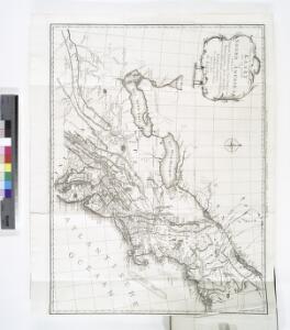
Middle British colonies in America
from Parts
Spojené státy severoamerické III. Východní část

Part of North America: comprehending the course of Ohio, New England, New York, New Jersey, Pennsylvania, Maryland, Virginia, Carolina & Georgia.
from Parts
United States of Nth. America.
1 : 1584000 Tardieu, P.F.
Northern provinces of the United States / drawn & engraved for Thomson's New general atlas, 1817 ; Hewitt Sc. ...
from Parts
Map of the United States.
1 : 6750000 Scott, Joseph