Maps of North Atlantic Ocean
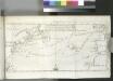
[Map of the North Atlantic Ocean to accompany Jonathan Williams' article on the use of the thermometer in discovering banks, soundings, etc..]; Transactions of the American Philosophical Society.
from Transactions of the American Philosophical Society. American Philosophical Society,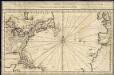
Carte de l'ocean occidental et partie de l'Amerique septentrionale
1 : 20000000
Carte réduite d'une partie de l'ocean Atlantique ou Occidental
1 Karte : Kupferdruck ; 46 x 81 cm Verdun de la Crenne; Borda; Pingré; Petit; Claret de Fleurieu s.n.
United States of America, 1834 / by H.S. Tanner; engraved by H.S. Tanner, assisted by E.B. Dawson, W. Allen & J. Knight.
from Whole Henry S. Tanner; E. B. Dawson; W. Allen; J. Knight,
Tierra nveva.
from Charts and maps Sesssa?: [Venice]; Ruscelli, Girolamo; Gastaldi, Giacomo,
A new map of part of the United States of North America : containing those of New York, Vermont, New Hampshire, Massachusets, Connecticut, Rhode Island, Pennsylvania, New Jersey, Delaware, Maryland and Virginia from the latest authorities / by John Cary,
from Charts and maps
Nieuwe pas-caart; vertoonende, hoemen uyt de canaal, de custen van Portugael, Barbarijen, de Canarische en Vlaemsche eylanden beseylen zal
1 Karte : Kupferdruck ; 42 x 54 cm Doncker by Hendrick Doncker boekverkoper inde Nieubrugsteech in 't Stuurmans gereetschap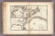
Gulf-Stream.
1 : 15000000 Vincent
Map of the western parts of the colony of Virginia / J. Gibson sculpt.
from Virginia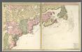
Nova tabula geographica complectens borealiorem Americae partem.
from Charts and maps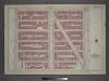
Plate 4: Part of Section 7.
from Atlas of the city of New York, borough of Manhattan / from actual surveys and official plans by George W. and Walter S. Bromley.
Theatre de la guerre presente en Amerique.
from Revolutionary War, 1775-1783
Partie orientale du Canada ou de la Nouvelle France : ou sont les provinces, ou pays de Sagvenay, Canada, Acadie etc., les peuples, ou nations des Etechemins, Iroquois, Attiquameches etc., auec la Nouvelle Angleterre, la Nouvelle Ecosse, la Nouvelle Yorc
from Canada

A new map of part of the United States of North America : containing those of New York, Vermont, New Hampshire, Massachusets, Connecticut, Rhode Island, Pennsylvania, New Jersey, Delaware, Maryland and Virginia from the latest authorities / by John Cary,
from Parts
Ice Chart, Grand Banks Region, July.
U.S. Navy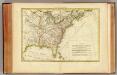
L'Amerique Septentrionale 2.
1 : 10050000 Bonne, Rigobert, 1727-1794
A new and exact map of the dominions of the King of Great Britain on ye continent of North America : containing Newfoundland, New Scotland, New England, New York, New Jersey, Pensilvania, Maryland, Virginia and Carolina / according to the newest and most
from The world described, or, A new and correct sett of maps : shewing the kingdoms and states in all the known parts of the earth, with the principal cities, and most considerable towns in the world ... / ... by Herman Moll, geographer ...
A new map of the British colonies in North America : shewing the seat of the present war, taken from the best surveys, compared with and improved from manuscripts of several noblemen and gentlemen / by John Andrews.
from Charts and maps
Ice Chart, Grand Banks Region, October.
U.S. Navy
Carte nouvelle contenant la partie d'Amerique la plus septentrionale, ou sont exactement dêcrites les provinces suivantes comme le Canada ou Nouvelle France, la Nouvelle Ecosse, la Nouvelle Angleterre, les Nouveaux Païs Bas, la Pensylvanie, la Virginie, la Caroline et l'jle de Terre Neuve, avec les profondeurs le long des côtes et sur les bancs
1 : 4000000 par Nicolas Visscher L. v. Anse schulp. [Amstelodami] : nunc apud Petrum Schenk Junior
A new map of the British colonies in North America : shewing the seat of the present war, taken from the best surveys, compared with and improved from manuscripts of several noblemen and gentlemen / by John Andrews.
From Charts and maps
The Western Ocean.
from Charts and maps Jeremiah Seller & Charles Price?: [London?],
Virginia et Nova Francia.
from Charts and maps Sumptibus et typis aeneis Iudoci Hondij: [Amsterdami]; Bertius, Petrus. La geographie racourcie.; Hondius, Jodocus,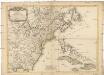
Carte des possessions angloises dans l'Amerique Septentrionale
1 : 3500000 Spojené státy americké-oblast východní Imbert, J. Leopold chez Mondhare
A map of the British-plantations on the continent of America / Stephens fecit.
from Charts and maps Stephens fecit,
Ice Chart, Grand Banks Region, March.
U.S. Navy
Canada et Louisiane / par le Sr. le Rouge ingénieur géographe du Roy.
from Charts and maps
Ice Chart, Grand Banks Region, September.
U.S. Navy
![[Map of the North Atlantic Ocean to accompany Jonathan Williams' article on the use of the thermometer in discovering banks, soundings, etc..]; Transactions of the American Philosophical Society.](https://images-2.georeferencer.com/images/iiif/364721872829/full/,300/0/native.jpg)

