Maps of Kings County

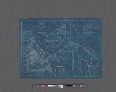
Plan of the U. S. Navy Yard, N. Y., showing improvements up to July 1, 1894.
From Brooklyn
[Plate 36: Bounded by Fifteenth Street, Eleventh Avenue, 19th Street, Tenth Avenue, 20th Street and Ninth Avenue. (Includes the Plan of Prospect Park.)]
from Robinson's atlas of the city of Brooklyn, New York : embracing all territory within its corporate limits; from official records ... / by and under the supervision of E. Robinson and R.H. Pidgeon, civil engineers.
Brooklyn, Vol. 3, Double Page Plate No. 1; Part of Ward 19, Section 8; [Map bounded by Lee Ave., Taylor St., Wythe Ave., Franklin Ave., Flushing Ave., Washington Ave., Wallabout Channel, Division Ave.]
from Wards 13, 14, 15, 16, 17, 18, 19, 27 & 28.
Brooklyn, Vol. 3, Double Page Plate No. 6; Part of Wards 13, 14, 15 & 16, Sections 8, 9 & 10; [Map bounded by Metropolitan Ave., Leonard St., Meserole St., S. Fourth St., Keap St., Broadway; Including Havemeyer St., S. Third St., Roebli
from Wards 13, 14, 15, 16, 17, 18, 19, 27 & 28.
Brooklyn, Vol. 1, 2nd Part, Double Page Plate No. 29; Part of Wards 7 & 19, Section 7 & 8; [Map bounded by Marcy Ave., Heyward St., Lee Ave., Flushing Ave., Bedford Ave.; Including Willoughby Ave., Washington Ave., Cross St., Wallabout Channel, Divisi...
From Volume 1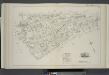
Vol. 6. Plate, N. [Map bound by S. Sixth St., Broadway, Seventh St., Division Ave., S. Eleventh St., East River; Including S. Eighth St., S. Ninth St., S. Tenth St., First St., Second St., Third St., Fourth St., Fifth St., Sixth St.]
from Detailed estate and old farm line atlas of the city of Brooklyn : complete in six volumes ... from official records, private plans, and actual surveys ... / by G.M. Hopkins, C.E.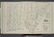
Vol. 6. Plate, S. [Map bound by Lee Ave., Flushing Ave., Classon Ave., Hewes St., Canal, Wilson St.; Including Bedford Ave., Wythe Ave., Kent Ave., Ross St., Rodney St., Keap St., Hooper St., Penn St., Rutledge St., Heyward St., Lynch St., Middleton St.,
from Detailed estate and old farm line atlas of the city of Brooklyn : complete in six volumes ... from official records, private plans, and actual surveys ... / by G.M. Hopkins, C.E.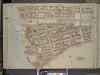
Brooklyn, Vol. 3, Double Page Plate No. 7; Part of Ward 13, Section 8; [Map bounded by South Third St., Haveneyer St.; Including Division Ave., East River]
from Wards 13, 14, 15, 16, 17, 18, 19, 27 & 28.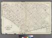
[Plate 20: Bounded by S. 11th Street, Division Avenue, Broadway, Heyward Street, Harrison Avenue, Middleton Street, Marcy Avenue, Flushing Avenue, Classon Avenue, Kent Avenue and 1st Street.]
from Atlas of the entire city of Brooklyn, complete in one volume. From actual surveys and official records by G. W. Bromley & Co.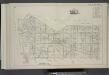
Vol. 5. Plate, A. [Map bound by U.S. Navy Yard, Concord St., Bridge St., East River; Including Little St., Navy St., Old Bridge RD, Hudson St., Greene Lane, Gold St., Charles St., Duffield St., U.S. St., Marshall St., John St., PLymouth St., Evans St., W
from Detailed estate and old farm line atlas of the city of Brooklyn : complete in six volumes ... from official records, private plans, and actual surveys ... / by G.M. Hopkins, C.E.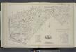
Vol. 6. Plate, T. [Map bound by First St., Second St., S.11th St., Third St., S.10th St., Fourth St., 5th St., 6th St., 7th St., 8th St., 9th St., Rodney St., Marcy Ave., Keap St., Lee Ave., Wilson St., Canal, East River; Including Division Ave., Rush St
from Detailed estate and old farm line atlas of the city of Brooklyn : complete in six volumes ... from official records, private plans, and actual surveys ... / by G.M. Hopkins, C.E.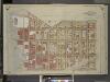
Brooklyn, Vol. 1, Double Page Plate No. 2; Part of Wards 2 & 5, Section 1; [Map bounded by Little St., Evans St., Hudson Ave., Navy St.; Including Concord St., Jay St., Marshall St.]
from Wards 1, 2, 3, 4, 5, 6, 8, 9, 10, 12 & 22.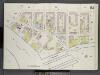
Brooklyn V. 3, Double Page Plate No. 61 [Map bounded by Division Ave., Wythe Ave., Ross St., East River]
From Atlas 69. Vol. 3, 1887.
[Plate 2: Map bounded by South 8th Street, 1st Street, Division Street, Devoe Street, Union Avenue, Ainslie Street, 1st Street, 9th Street, Smith Street, Messerole Street, Scholl Street, Waterbury Street, Remsen Street, Wyckoff Street]
from Maps of the city of Brooklyn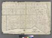
Plate 1: Ward 5 & Part of Wards 2, 4 & 11.
from Atlas of the entire city of Brooklyn, complete in one volume. From actual surveys and official records by G. W. Bromley & Co.
Brooklyn V. 3, Plate No. 29 [Map bounded by Hooper, Wythe Ave., Franklin Ave., Flushing Ave., Classon Ave., Wallabout PL.]
From Atlas 71. Vol. 3, 1918.
[Plate 12: Map bounded by York Street, Navy Street, Condord Street, Jay Street]
from Maps of the city of Brooklyn
[Plate 3: Map bounded by East River, Brooklyn Navy Yard, York Street, Bridge Street]
from Maps of the city of Brooklyn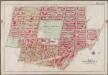
Plate 5: [Bounded by Clermont Avenue, Greene Avenue, S. Portland Avenue, Atlantic Avenue, Fourth Avenue, Flatbush Avenue, Schermerhorn Street, Bond Street, Dekalb Avenue, Gold Street, Tillary Street, Navy Street & Flushing Avenue]; Atlas of the borough of Brooklyn, city of New York: from actual surveys and official plans by George W. and Walter S. Bromley.
from Atlas of the borough of Brooklyn, city of New York : from actual surveys and official plans by George W. and Walter S. Bromley. G.W. Bromley & Co.,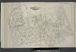
Vol. 5. Plate, D. [Map bound by Sands St., U.S. Navy Yard, Portland Ave., Myrtle Ave., Canton St., Bolivar St., Fleet Place, Pearl St., Concord St., Jay St.; Including High St., Nassau St., Flushing Ave., Chapel St., Park Ave., Tillary St., Sycamore St.,
from Detailed estate and old farm line atlas of the city of Brooklyn : complete in six volumes ... from official records, private plans, and actual surveys ... / by G.M. Hopkins, C.E.
[Plate 20: Map bounded by Flushing Avenue, Cumberland Street, Myrtle Avenue, Raymond Street, Park Avenue, Navy Street]
from Maps of the city of Brooklyn
[Plate 21: Map bounded by Flushing Avenue, Clinton Avenue, Myrtle Avenue, Cumberland Street]
from Maps of the city of Brooklyn
[Map bounded by Cherry St, Corlears St, Pier - Line, Montgomery St; Including Water St, Front St, South St, Gouverneur Slip, Ferry to Hudson Av, Jackson St]
from Maps of the wharves & piers from the Battery to 61st street on the Hudson river and from the Battery to 41st street on the East river, New York. Surveyed by I.C. Buckhout, city surveyor.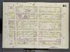
Brooklyn V. 3, Double Page Plate No. 64 [Map bounded by Bedford Ave., Myrtle Ave., Classon Ave., Wallabout St.]
From Atlas 69. Vol. 3, 1887.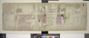
Double Page Plate No. 1; [Map bounded by John St., Bridge St., East River, Little St.; Including Marshall St., Hudson Ave., Gold St.]
from Insurance maps of the warehouses, &c., in Brooklyn from the Navy yard to Partition Street.
[Plate 36: Maps Covering Various Areas]
from Maps of the city of Brooklyn
[Plate 19: Map bounded by Concord Street, Navy Street, Park Avenue, Raymond Street, Willoughby Street, Duffield Street]
from Maps of the city of Brooklyn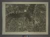
12D - N.Y. City (Aerial Set).
from Sectional aerial maps of the City of New York / [photographed and assembled under the direction of the chief engineer, July 1st, 1924].
Plate 9: Part of Wards 13, 16 & 19. Brooklyn, N.Y.
from Robinson's atlas of the city of Brooklyn, New York : embracing all territory within its corporate limits; from official records ... / by and under the supervision of E. Robinson and R.H. Pidgeon, civil engineers.