Maps of North New Hyde Park
Area District Map Section No. 11
From Area district map
Bayside, Auburndale, Oakland Gardens, Little Neck, Douglaston. (cont.)
From District 11
Land use policy (cont.)
From District 11
Height District Map Section No. 11; Height district map / City of New York, Board of Estimate and Apportionment.
from Height district map / City of New York, Board of Estimate and Apportionment. New York (N.Y.). Board of Estimate and Apportionment,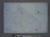
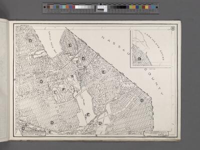
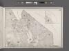
Area District Map Section No. 11; Area district map / City of New York, Board of Estimate and Apportionment.
from Area district map / City of New York, Board of Estimate and Apportionment. New York (N.Y.). Board of Estimate and Apportionment,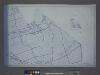
Use District Map Section No. 11; Use district map / City of New York, Board of Estimate and Apportionment.
from Use district map / City of New York, Board of Estimate and Apportionment. New York (N.Y.). Board of Estimate and Apportionment,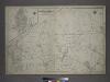
[Plate 30: Bounded by Nassau Road, Broadway, Clinton Avenue, East Alley Road, Little Neck Road, Jericho Turnpike, Rocky Hill Road, Alley Road and Broadway.]
from Atlas of the city of New York, borough of Queens, Long Island City, Newtown, Flushing, Jamaica, Far Rockaway, from actual surveys and official plans / by George W. and Walter S. Bromley.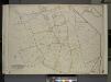
Queens, Vol. 3, Double Page Plate No. 20; Part of ward Three Sub Plan No. 1; [Map bounded by Broadway, Little Neck Road, West end Drive, Lakeville Road]; Part of ward Three Sub Plan No. 2; [Map bounded by Little Neck Bay]; Part of ward Thre
from Third ward: Flushing.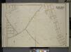
Queens, Vol. 3, Double Page Plate No. 15; Part of ward Three Whitestone; [Map bounded by 14th Ave., 11th Ave., Ave. A, Ave. B, Ave. C, Lane, Penn Ave., Willets Point Road, Whitestone Road, Fairview Ave., Plateau Ave., Bay View Ave.; Includ
from Third ward: Flushing.
11B - N.Y. City (Aerial Set).
from Sectional aerial maps of the City of New York / [photographed and assembled under the direction of the chief engineer, July 1st, 1924].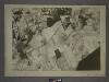
11D - N.Y. City (Aerial Set).
from Sectional aerial maps of the City of New York / [photographed and assembled under the direction of the chief engineer, July 1st, 1924].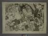
11C - N.Y. City (Aerial Set).
from Sectional aerial maps of the City of New York / [photographed and assembled under the direction of the chief engineer, July 1st, 1924].
11A - N.Y. City (Aerial Set).
from Sectional aerial maps of the City of New York / [photographed and assembled under the direction of the chief engineer, July 1st, 1924].
Key
From Atlas 139. Vol. 4, 1901.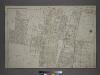
Part of the Borough of Queens, Flushing, Ward 3.
from Atlas of the city of New York, borough of Queens, Long Island City, Newtown, Flushing, Jamaica, Far Rockaway, from actual surveys and official plans / by George W. and Walter S. Bromley.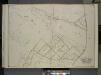
Queens, Vol. 3, Double Page Plate No. 21; Part of ward Three Sub Plan; [Map bounded by Little Neck Bay, Odalls Cove; Including Bay St., Allen St.]; Part of ward Three Douglaston and Little Neck; [Map bounded by Boundary Line of City of New York a
from Third ward: Flushing.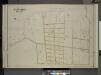
Queens, Vol. 3, Double Page Plate No. 16; Part of ward Three Bayside; [Map bounded by Bell Ave., Little Bayside Road, Shore Ave., Kneeland Ave., Bayside Ave., Bradish Ave., Nicoll Ave., Vista Ave., Cracheron Ave., Waldo Ave., Castor Ave., Fran
from Third ward: Flushing.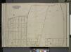
Queens, Vol. 3, Double Page Plate No. 17; Part of ward Three Bayside; [Map bounded by Titus Ave., Rocky Hill Road, Woodhull Ave., Bradford Ave., Torrey Ave., Higgins Ave., Hurd Ave., Jones Ave., Prince Ave., Stratton Ave., Mauriac Ave., Vernon
from Third ward: Flushing.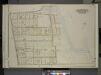
Queens, Vol. 3, Double Page Plate No. 18; Part of ward Three Bayside; [Map bounded by Crocheron Ave., Bayside Boulevard, Bell Ave., Bismarck Ave., Lamartine Ave., Warburton Ave., Ashburton Ave., Montauk Ave., Lawrence Boulevard, Broadway,
from Third ward: Flushing.
Part of Great Neck Estate; Glen Head
from Atlas of Nassau County, Long Island, N.Y. Complete in one volume. Historical, statistical. Based upon maps on file at the county seat in Mineola and upon private plans and surveys furnished by surveyors and individual owners. Supplemented by careful measurements & field observations by our own corps of engineers.
Great Neck Ests. - Manhasset - Roslyn - Mineola, Etc.
from Atlas of Nassau County, Long Island, N.Y. Complete in one volume. Historical, statistical. Based upon maps on file at the county seat in Mineola and upon private plans and surveys furnished by surveyors and individual owners. Supplemented by careful measurements & field observations by our own corps of engineers.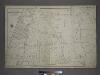
Part of the Borough of Queens, Flushing, Ward 3.
from Atlas of the city of New York, borough of Queens, Long Island City, Newtown, Flushing, Jamaica, Far Rockaway, from actual surveys and official plans / by George W. and Walter S. Bromley.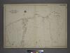
[Plate 26: Willets Point Road (Little Bay), Bell Avenue (Little Neck Bay), Bayside Road and Weststone Road. ]
from Atlas of the city of New York, borough of Queens, Long Island City, Newtown, Flushing, Jamaica, Far Rockaway, from actual surveys and official plans / by George W. and Walter S. Bromley.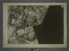
15B - N.Y. City (Aerial Set).
from Sectional aerial maps of the City of New York / [photographed and assembled under the direction of the chief engineer, July 1st, 1924].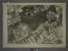
15A - N.Y. City (Aerial Set).
from Sectional aerial maps of the City of New York / [photographed and assembled under the direction of the chief engineer, July 1st, 1924].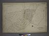
Part of the Borough of Queens, Flushing, Ward 3.
from Atlas of the city of New York, borough of Queens, Long Island City, Newtown, Flushing, Jamaica, Far Rockaway, from actual surveys and official plans / by George W. and Walter S. Bromley.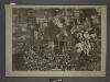
10B - N.Y. City (Aerial Set).
from Sectional aerial maps of the City of New York / [photographed and assembled under the direction of the chief engineer, July 1st, 1924].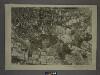
10D - N.Y. City (Aerial Set).
from Sectional aerial maps of the City of New York / [photographed and assembled under the direction of the chief engineer, July 1st, 1924].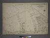
[Plate 38: Bounded by Hillside Avenue, Rocky Hill Road, Hamilton Avenue, Jericho Turnpike, & Hempstead and Jamaica Plank Road.]
from Atlas of the city of New York, borough of Queens, Long Island City, Newtown, Flushing, Jamaica, Far Rockaway, from actual surveys and official plans / by George W. and Walter S. Bromley.