Maps of Bayonne

Jersey City, V. 1, Double Page Plate No. 38 [Map bounded by Avenue E, E. 22nd St., Kill Von Kull, Hobart Ave.] / compiled under the direction of and published by G.M. Hopkins Co.
From V. 1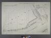
Sheet No. 2. [Includes Richmond Terrace in Staten Island, Port Johnson, New Jersey and Richmond Borough Boundary Line, and, Bayonne in New Jersey.]
from Borough of Richmond, Topographical Survey.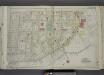
Part of Ward 3. [Map bound by Richmond Ave, Richmond Terrace, Pierhead and Bulkhead Line, Palmers Run/ Bodines Pond, Jewett Ave, Simonson PL, Anderson Ave (New York Ave), Washington PL, Albion PL]; Atlas of the city of New York, borough of Richmond, Staten Island. From actual surveys and original plans, by George W. and Walter S. Bromley.
from Atlas of the city of New York, borough of Richmond, Staten Island. From actual surveys and original plans, by George W. and Walter S. Bromley. Bromley, George Washington,
Jersey City, V. 1, Double Page Plate No. 35 [Map bounded by Newark Bay, E. 42nd St., W. 42nd St., Avenue E, E. 24th St., W. 24th St.] / compiled under the direction of and published by G.M. Hopkins Co.
From V. 1
West New Brighton.
from Atlas of Staten Island, Richmond County, New York, from official records and surveys; compiled and drawn by F. W. Beers.
Jersey City, V. 1, Double Page Plate No. 39 [Map bounded by New York Bay, Kill Von Kull, E. 22nd St.] / compiled under the direction of and published by G.M. Hopkins Co.
From V. 1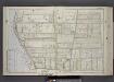
Part of Ward 1. [Map bound by Sailors Snug Harbor, Henderson Ave, Castleton Ave, Forest Ave, Broadway, Kill Van Kull]
from Atlas of the borough of Richmond, city of New York.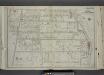
Part of Ward 1. [Map bound by N. Burgher Ave (Burgher), Richmond Terrace, Pierhead Line, Kissel Ave, Henderson Ave, Bard Ave, Castleton Ave, Fairmount Ave, Pelton Ave (Hill St), Oakland Ave, Cary Ave]
from Atlas of the city of New York, borough of Richmond, Staten Island. From actual surveys and original plans, by George W. and Walter S. Bromley.
Jersey City, V. 1, Double Page Plate No. 37 [Map bounded by North St., Hobart Ave., Kill Von Kull, Newark Bay] / compiled under the direction of and published by G.M. Hopkins Co.
From V. 1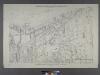
Borough of Richmond, Topographical Survey.
from Borough of Richmond, Topographical Survey.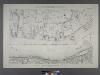
Borough of Richmond, Topographical Survey.
from Borough of Richmond, Topographical Survey.
Part of New Brighton.
from Atlas of Staten Island, Richmond County, New York, from official records and surveys; compiled and drawn by F. W. Beers.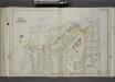
Part of Ward 1. [Map bound by Pierhead Line, N. Burgher Ave (Burgher Ave), Castleton Ave, Clove Road (Columbia St), Richmond Terrace]
from Atlas of the city of New York, borough of Richmond, Staten Island. From actual surveys and original plans, by George W. and Walter S. Bromley.
Staten Island, V. 1, Plate No. 48 [Map bounded by Kill Van Kull, Woodruff Lane, Barker, Trinity Pl., Taylor]
From Atlas 162. Vol. 1, 1917.
Bayonne; Greenville Twp.
1 : 19200 Beers, F. W. (Frederick W.)
Brighton Heights, Clifton, Fort Wadsworth, Fox Hills, Grymes hill, Livingston, New Brighton, Randall Manor, Rosebank, Shore Acres, St. George, Stapleton, Tompkinsville, Ward hill, West New Brighton. (cont.)
From District 2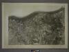
21A - N.Y. City (Aerial Set).
from Sectional aerial maps of the City of New York / [photographed and assembled under the direction of the chief engineer, July 1st, 1924].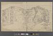
Map of New Brighton, Staten Island [cartographic material] : 1st, 2nd and 3rd wards.
From Staten Island
Height District Map Section No. 21; Height district map / City of New York, Board of Estimate and Apportionment.
from Height district map / City of New York, Board of Estimate and Apportionment. New York (N.Y.). Board of Estimate and Apportionment,
Area District Map Section No. 21; Area district map / City of New York, Board of Estimate and Apportionment.
from Area district map / City of New York, Board of Estimate and Apportionment. New York (N.Y.). Board of Estimate and Apportionment,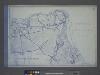
Use District Map Section No. 21; Use district map / City of New York, Board of Estimate and Apportionment.
from Use district map / City of New York, Board of Estimate and Apportionment. New York (N.Y.). Board of Estimate and Apportionment,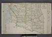
Part of Ward 1. [Map bound by Broadway, Forest Ave, Cherry Lane, Jewett Ave, Richmond Terrace, Creek, Kill Van Kull]
from Atlas of the borough of Richmond, city of New York.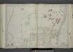
Part of Ward 1. [Map bound by Kissel Ave, Richmond Terrace, Pierhead and Bulkhead Line, La Fayette Ave, 2nd Ave, 1st Ave, Brighton Ave, Castleton Ave]
from Atlas of the city of New York, borough of Richmond, Staten Island. From actual surveys and original plans, by George W. and Walter S. Bromley.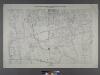
Sheet No. 10. [Includes Sailor's Snug Harbor (Livingston), Henderson Avenue, Castleton Avenue, Prospect Avenue, N.St.Austins Avenue, S. St. Austins Avenue, Brighton Avenue and Webster Avenue.]
from Borough of Richmond, Topographical Survey.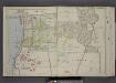
Part of Ward 1. [Map bound by Franklin Ave, Prospect Ave, "The Cedars", La Fayette Ave, Webster Ave, Castleton Ave, Brighton Ave, Forest Ave, Sailors Snug Harbor, Kill Van Kull]
from Atlas of the borough of Richmond, city of New York.
Village of Port Richmond.
from Atlas of Staten Island, Richmond County, New York, from official records and surveys; compiled and drawn by F. W. Beers.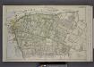
Part of Wards 1 & 3. [Map bound by Palmer's Run, Jewett Ave, Cherry Lane, Barrett Ave, Decker Ave, Richmond Ave, Prospect St, Grant St, Johnson Ave, Kill Van Kull]
from Atlas of the borough of Richmond, city of New York.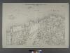
Sheet No. 8. [Includes New York and New Jersey Boundary Line, Elm Park and Port Richmond,]
from Borough of Richmond, Topographical Survey.
Staten Island, V. 1, Plate No. 52 [Map bounded by Trinity Pl., Woodruff Lane, Henderson Ave., Broadway, Cary Ave., Taylor]
From Atlas 162. Vol. 1, 1917.
![Jersey City, V. 1, Double Page Plate No. 38 [Map bounded by Avenue E, E. 22nd St., Kill Von Kull, Hobart Ave.] / compiled under the direction of and published by G.M. Hopkins Co.](https://images-2.georeferencer.com/images/iiif/571797370855/full/,300/0/native.jpg)

