Maps of Jersey City

Jersey City, V. 1, Double Page Plate No. 18 [Map bounded by Van Horne St., Grand St., Monmouth St., Jersey Ave., Phillip St.] / compiled under the direction of and published by G.M. Hopkins Co.
From V. 1
Jersey City, V. 1, Double Page Plate No. 17 [Map bounded by Madison Ave., Summit Ave., Balowin Ave., Montgomery St., Bright St., Van Horne St., Bramhall Ave.] / compiled under the direction of and published by G.M. Hopkins Co.
From V. 1
Jersey City, V. 1, Double Page Plate No. 27 [Map bounded by Morris Canal, Sussex St., Hudson River, New York Bay, Jersey Ave.] / compiled under the direction of and published by G.M. Hopkins Co.
From V. 1
Jersey City, V. 1, Double Page Plate No. 19 [Map bounded by Ocean Ave., Bramhall Ave., Bay View Ave.] / compiled under the direction of and published by G.M. Hopkins Co.
From V. 1
Jersey City, V. 1, Double Page Plate No. 8 [Map bounded by Prior St., 3rd St., Monmouth St., Grand St.] / compiled under the direction of and published by G.M. Hopkins Co.
From V. 1
Jersey City, V. 1, Double Page Plate No. 2 [Map bounded by Monmouth St., 2nd St., Erie St., Grove St., Morris Canal] / compiled under the direction of and published by G.M. Hopkins Co.
From V. 1
Plan of the city of New York in North America : surveyed in the years 1766 & 1767 / B. Ratzer, lieutt. in His Majestys 60th or Royal American Regt. ; Thos. Kitchin, sculpt., engraver to His Late Royal Highness, the Duke of York, &c.
From Manhattan
Topographical atlas of the City of New York / by Egbert L. Viele.
from Topographical atlas of the city of New York, / including the annexed territory showing original water courses and made land / prepared under the direction of Egbert L. Viele.
Road from Philadelphia to New York. (Maps) 14 and 15.
1 : 63360 Moore, S.S.
Hudson River Vehicular Tunnel [Holland Tunnel]
From Manhattan
Jersey City, V. 1, Double Page Plate No. 26 [Map bounded by New York bay] / compiled under the direction of and published by G.M. Hopkins Co.
From V. 1
12C - N.Y. City (Aerial Set).
from Sectional aerial maps of the City of New York / [photographed and assembled under the direction of the chief engineer, July 1st, 1924].
[Volume 1 Index Map]
from Maps of the city of New York.
Jersey City, V. 1, Double Page Plate No. 9 [Map bounded by Summit Ave., Washburn St., Division St., Bright St.] / compiled under the direction of and published by G.M. Hopkins Co.
From V. 1
Jersey City, V. 1, Double Page Plate No. 16 [Map bounded by Montgomery St., Summit Ave., Crescent Ave., Communipaw Ave., Olean Ave.] / compiled under the direction of and published by G.M. Hopkins Co.
From V. 1
Jersey City, V. 1, Double Page Plate No. 20 [Map bounded by Communipaw Ave., Madison Ave., Clerk St., Orient Ave., West Side Ave.] / compiled under the direction of and published by G.M. Hopkins Co.
From V. 1
Jersey City, V. 1, Double Page Plate No. 40 [Map bounded by E. 40th St., New York Bay, E. 21st St.] / compiled under the direction of and published by G.M. Hopkins Co.
From V. 1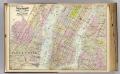
1 New York, Brooklyn, Jersey City.
1 : 18300 Watson, Gaylord
Topographical atlas of the city of New York, including the annexed territory showing original water courses and made land. / prepared under the direction of Egbert L. Viele.
From Topographical atlas of the city of New York, including the annexed territory showing original water courses and made land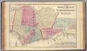
Hoboken, Jersey City.
1 : 19200 Beers, F. W. (Frederick W.)
Greenwich Village, West Village, Little Italy. (cont.)
From District 2
Lower Manhattan, The Battery, Wall Street, Civic Center, Governor's Island.
From District 1
Topographical map of the city of Brooklyn as reduced from the original maps on file showing farm lines, modern improvements, etc.
From Brooklyn
Jersey City
1 : 24000
Jersey City
1 : 24000
Jersey City
1 : 24000
Jersey City
1 : 24000
Jersey City
1 : 24000
Dutch Era Land Grants in Stokes Iconography sheet with Greenwich Village & Lower Manhattan.
from Manhattan
![Jersey City, V. 1, Double Page Plate No. 18 [Map bounded by Van Horne St., Grand St., Monmouth St., Jersey Ave., Phillip St.] / compiled under the direction of and published by G.M. Hopkins Co.](https://images-2.georeferencer.com/images/iiif/741866515315/full/,300/0/native.jpg)

