Maps of Union City
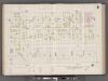
Hudson County, V. 8, Double Page Plate No. 6 [Map bounded by West St., Oak St., Palisade Ave., Charles St.] / surveyed and published by Chas. B. Brush. Vol. 8.
From Insurance maps of Hudson County, New Jersey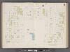
Hudson County, V. 8, Double Page Plate No. 5 [Map bounded by Kerrigan Ave., Oak St., West St., Charles St.] / surveyed and published by Chas. B. Brush. Vol. 8.
From Insurance maps of Hudson County, New Jersey
Plan of Weehawken Township.
1 : 9600 Hopkins, G.M.
8A - N.Y. City (Aerial Set).
from Sectional aerial maps of the City of New York / [photographed and assembled under the direction of the chief engineer, July 1st, 1924].
Plan of Weehawken township.
from Combined atlas of the State of New Jersey and the County of Hudson : from actual survey, official records & private plans / by and under the direction of G. M. Hopkins ...
[Volume 7 Index Map.]
from Maps of the city of New York / surveyed under directions of insurance companies of said city.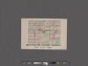
[Maps of the 14, 15, 16, 17, 20, 21 assembly districts and 23 & 24 Wards of New York City.]
From Manhattan
Topographical Atlas Of The City Of New York
1 : 12000 Viele, Egbert L.
[Volume 6 Index Map.]
from Maps of the city of New York / surveyed under directions of insurance companies of said city.
New map of that part of the city of New York south from 20th Street on the Hudson & 35th Street on the East River : showing the position of Greenwich, Washington and West Streets on the Hudson River, and Pearl, Water, Front, Cherry & Tompkins Sts. on the
from Manhattan
Area District Map Section No. 8
from Area district map / City of New York, Board of Estimate and Apportionment.
Height District Map Section No. 8
from Height district map / City of New York, Board of Estimate and Apportionment.
Use District Map Section No. 8
from Use district map / City of New York, Board of Estimate and Apportionment.
Map of the City of New-York with part of Brooklyn and Williamsburgh : population in the year 1850: 450,000 inhabitants.
from Manhattan
Map of the City of New-York with part of Brooklyn and Williamsburgh : population in the year 1850: 450,000 inhabitants / D. Völker, sc.
from Manhattan
New York City and the Adjacent Cities.
1 : 20000 Colton, G.W.
1 New York, Brooklyn, Jersey City.
1 : 18300 Watson, Gaylord
Map of the city of New York, 1850 / drawn for D.T. Valentine's Manual 1850, by G. Hayward.
from Manhattan
Queens, Vol. 2, Double Page Plate No. 9; Part of Long Island City Ward One (Part of Old Wards 4 and 5); [Map bounded by Woolsey Ave., Albert St., Potter Ave.; Including Old Bowery Bay Road, Jamaica Ave., Debevoise Ave.]
from First and second wards: Long Island City and Newtown.
Map of the city of New York : with street directory showing house-numbers, hotels, churches, banks, theatres, ferries, house-car, steam and elevated R.R'ds, &c
1 : 12670 Dripps, M. (Matthew) M. Dripps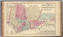
Hoboken, Jersey City.
1 : 19200 Beers, F. W. (Frederick W.)
Greenwich Village, West Village, Little Italy. (cont.)
From District 2
Topographical atlas of the city of New York, including the annexed territory showing original water courses and made land. / prepared under the direction of Egbert L. Viele.
From Topographical atlas of the city of New York, including the annexed territory showing original water courses and made land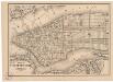
Map of the city of New York
1 mapa. Datat a partir de 1900 aproximadament. D. Appleton & Co.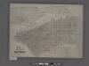
Map of the city of New York showing the original high water line and the location of the different farms and estates.
From Manhattan
New York.
from Manhattan
The Great metropolis in 1804.
from Manhattan
Weehawken
1 : 24000
Weehawken
1 : 24000
Weehawken
1 : 24000
Weehawken
1 : 24000
Weehawken
1 : 25000
Weehawken
1 : 25000
Weehawken
1 : 31680
Weehawken
1 : 31680
![Hudson County, V. 8, Double Page Plate No. 6 [Map bounded by West St., Oak St., Palisade Ave., Charles St.] / surveyed and published by Chas. B. Brush. Vol. 8.](https://images-2.georeferencer.com/images/iiif/236425288106/full/,300/0/native.jpg)

