Maps of Englewood
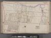
Bergen County, V. 1, Double Page Plate No. 9 [Map bounded by Overpeck Creek, Cedar Lane, Phelps Ave., Broad Ave., Borough Blvd., Oakdene Ave.] / by George W. and Walter S. Bromley.
From V. 1, 1912.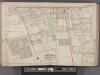
Bergen County, V. 1, Double Page Plate No. 8 [Map bounded by W. Palisade Ave., Dana Pl., Broad Ave., Teaneck Rd.] / by George W. and Walter S. Bromley.
From V. 1, 1912.
Map of the lands included in the Central Park, from a topographical survey, June 17th, 1856; [Also:] Plan for the improvement of the Central Park, adopted by the Commissioners, June 3rd, 1856.
from Manhattan
Portion of Bergen County, N.J.
from Atlas of the Hudson River Valley from New York city to Troy, including a section of about 8 miles in width. Published by Watson & co. Compiled from official records and careful surveys, under the supervision of F. W. Beers.
Washington Heights, Inwood, Marble Hill. (cont.)
From District 12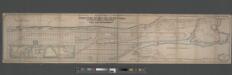
Map of the Upper Part of New York from 57th St. to Kingsbridge showing the "West Side Improvements," with dimensions, elevations of grade, & distances complete.
From Manhattan
Central Harlem. (cont.)
From District 10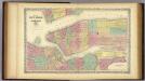
Map Of New York And The Adjacent Cities.
1 : 20500 Colton, G.W.
Guide Map to 92 Acres of Land at Washington Heights in the 12th Ward of the City of New York to be sold by the executors of Isaac Dykman Decd.
From Manhattan
A topographical map of the northn. part of New York Island : exhibiting the plan of Fort Washington, now Fort Knyphausen, with the rebels lines to the southward, which were forced by the troops under the command of the Rt. Honble. Earl Percy on the 16th. Novr. 1776, and survey'd immediately after by order of His Lordship
1 : 20000 Sauthier, Claude Joseph Wm. Faden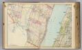
3 Bergen Co., N.J.
1 : 14400 Watson & Co. (New York, N.Y.)
City And County Of New - York North Of 50th St.
1 : 4800 Jones, R.A.
Insurance maps of the City of New York. Surveyed and published by Sanborn-Perris Map Co., Limited, 115 Broadway, 1893. Volume 11 1/2.
From Atlas 42.61. Vol. 11-11 1/2, 1893.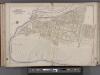
Bergen County, V. 1, Double Page Plate No. 12 [Map bounded by Hackensack River, Hackensack Ave., Township of Teaneck, Overpeck Creek] / by George W. and Walter S. Bromley.
From V. 1, 1912.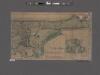
Topographical map of the city of New York, showing original water courses and made land ; prepared under direction of Egbert L. Viele, Topogr. Eng'r. Bound with his Topography and Hydrology of New York.
From Manhattan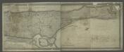
[Map of the city of New York and island of Manhattan as laid out by the commissioners appointed by the Legislature, April 3, 1807]
from Manhattan
New York City
from Manhattan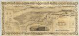
City and County Of New - York.
1 : 15840 Colton, J. H.
1. New York City.
1 : 80000 Servoss, R. D.
Lower East Side, East Village, Chinatown, Two Bridges. (cont.)
From District 3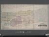
Colton's new map of the city and county of New York [North and South of 93rd St.] including the extension north of the Harlem River.
From Manhattan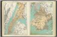
N.Y. City, Brooklyn.
1 : 41500 Bien, Joseph Rudolf
New York City.
1 : 41000 Rand McNally and Company
Queens, Vol. 2A, Double Page Plate No. 31; Part of Ward Two Newtown. [Map bounded by Lurting St., Flushing River, Rodman St.; Including Corona Ave., Tiemann Ave.] / by and under the supervision of Hugo Ullitz.
From v. 2A
New York City, County.
1 : 31680 Vermeule, C. C. (Cornelius Clarkson), 1858-1950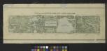
Plan of The Central Park, City of New York, 1860
from Manhattan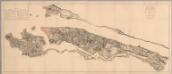
Composite: Steven's facsimile of British head quarters manuscript map of New York
1 : 9800 Stevens, Benjamin Franklin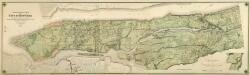
Composite: Topographical Atlas Of The City Of New York
1 : 12000 Viele, Egbert L.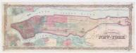
Colton's city & county map of New-York
1 : 20000 G.W. & C.B. Colton & Co G.W. and C.B. Colton
![Bergen County, V. 1, Double Page Plate No. 9 [Map bounded by Overpeck Creek, Cedar Lane, Phelps Ave., Broad Ave., Borough Blvd., Oakdene Ave.] / by George W. and Walter S. Bromley.](https://images-2.georeferencer.com/images/iiif/964997889789/full/,300/0/native.jpg)

