Maps of West Seneca
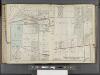
Buffalo, V. 3, Double Page Plate No. 18 [Map bounded by North Ave., Whitewood St., Berner St., Seneca St., Midvale St., Yards Ave.] / engraved by Albert Volk.
From v. 3
Lower Ebenezer [Village]
from Atlas of Erie County, New York.
Orchard Park
1 : 24000
Orchard Park
1 : 24000
Orchard Park
1 : 24000
Orchard Park
1 : 24000
Orchard Park
1 : 24000
Eden [Township]
from Atlas of Erie County, New York.
Erie County.
1 : 151000 Burr, David H., 1803-1875
Sketch of the Niagara River.
from Niagara River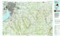
Buffalo
1 : 100000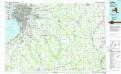
Buffalo
1 : 100000
Niagara and Erie counties.
1 : 158400 Bien, Joseph Rudolf
Map of Erie County
from New topographical atlas of Erie Co., New York, from actual surveys especially for this atlas.
Map of the county of Niagara / by David H. Burr ; engd. by Rawdon Clark & Co., Albany, & Rawdon Wright & Co., N. York.
from An atlas of the state of New York : containing a map of the state and of the several counties / by David H. Burr.
Map of the county of Niagara / by David H. Burr ; engd. by Rawdon Clark & Co., Albany, & Rawdon Wright & Co., N. York.
from An atlas of the state of New York : containing a map of the state and of the several counties. / Projected and drawn under the superintendence and direction of Simeon de Witt ... And also the physical geography of the State ...
Outline Plan of Niagara & Orleans Counties
from Atlas of Niagara and Orleans counties, New York. From actual surveys and official records. Compiled & published by Beers, Upton & Co.
Map of the county of Erie / by David H. Burr ; engd. by Rawdon, Clark & Co., Albany, & Rawdon, Wright & Co., New York.
from An atlas of the state of New York : containing a map of the state and of the several counties. / Projected and drawn under the superintendence and direction of Simeon de Witt ... And also the physical geography of the State ...
Buffalo
1 : 250000
Buffalo
1 : 250000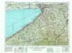
Buffalo
1 : 250000
Buffalo
1 : 250000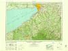
Buffalo
1 : 250000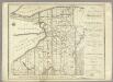
Map of Morris's Purchase or West Geneseo In the State of New York.
1 : 336000 Ellicott, Joseph & B.
Map of Morris's Purchase or West Geneseo in the state of New York : exhibiting part of the Lakes Erie and Ontario, the Straights of Niagara ...
1 : 336000 Ellicott, Joseph Holland Land Co.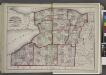
"Niagara, Erie, Chautauqua, Cattaraugus, Orleans, Genesee, Wyoming, Allegany, Monroe, and Livingston Counties"
from New topographical atlas and gazetteer of New York, comprising a topographical view of the several counties of the state, ... including ... map of the United States and territories ... Compiled from the latest astronomical observations, official surveys and records of the United States and territories ...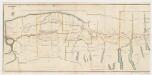
A new map and profile of the proposed canal from Lake Erie to Hudson River in the state of New York : Western sheet
1 : 253440 New York (State). Canal Commissioners W. A. Mercein, printer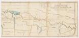
A new map and profile of the proposed canal from Lake Erie to Hudson River in the state of New York : Eastern sheet
1 : 253440 New York (State). Canal Commissioners W. A. Mercein, printer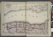
"Niagara, Orleans, Genesee, Monroe, and Wayne counties"
from New topographical atlas and gazetteer of New York, comprising a topographical view of the several counties of the state, ... including ... map of the United States and territories ... Compiled from the latest astronomical observations, official surveys and records of the United States and territories ...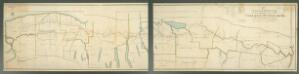
![Buffalo, V. 3, Double Page Plate No. 18 [Map bounded by North Ave., Whitewood St., Berner St., Seneca St., Midvale St., Yards Ave.] / engraved by Albert Volk.](https://images-2.georeferencer.com/images/iiif/284721311949/full/,300/0/native.jpg)

