Maps of Buffalo
Buffalo, V. 1, Double Page Plate No.1 [Map bounded by Kenmore Ave., Minnesota Ave., Hertel Ave., Dryden Ave.] / engraved by Albert Volk.
From v. 1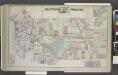
Parts of Eleventh and Twelfth Wards.
from Atlas of the City of Buffalo, Erie Co., New York : from actual surveys & official records.
Buffalo NE
1 : 24000
Buffalo NE
1 : 24000
Buffalo NE
1 : 24000
Buffalo.
1 : 16000 Rand McNally and Company
"Outline Map of Buffalo, New York."
from Atlas of the City of Buffalo, Erie Co., New York : from actual surveys & official records.
City of Buffalo
from Illustrated historical atlas of Erie Co., New York from actual surveys and records.
Buffalo.
1 : 32000 Rand McNally and Company
Tonawanda [Township]
from New topographical atlas of Erie Co., New York, from actual surveys especially for this atlas.
Buffalo
1 : 62500
Buffalo
1 : 62500
Buffalo
1 : 62500
Buffalo
1 : 62500
Buffalo
1 : 62500
Buffalo
1 : 62500
Buffalo
1 : 62500
Buffalo
1 : 62500
Buffalo
1 : 62500
Buffalo
1 : 62500
Buffalo
1 : 62500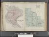
Buffalo, V. 3, Double Page Plate No. 27 [Map of Town of Grand Island, Part of the town of Amherst] / engraved by Albert Volk.
From v. 3
Erie County.
1 : 151000 Burr, David H., 1803-1875
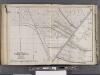
Sketch of the Niagara River.
from Niagara River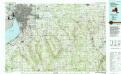
Buffalo
1 : 100000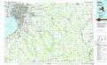
Buffalo
1 : 100000
Niagara and Erie counties.
1 : 158400 Bien, Joseph Rudolf
Map of Erie County
from New topographical atlas of Erie Co., New York, from actual surveys especially for this atlas.
Map of the county of Niagara / by David H. Burr ; engd. by Rawdon Clark & Co., Albany, & Rawdon Wright & Co., N. York.
from An atlas of the state of New York : containing a map of the state and of the several counties / by David H. Burr.
![Buffalo, V. 1, Double Page Plate No.1 [Map bounded by Kenmore Ave., Minnesota Ave., Hertel Ave., Dryden Ave.] / engraved by Albert Volk.](https://images-2.georeferencer.com/images/iiif/194245512510/full/,300/0/native.jpg)

