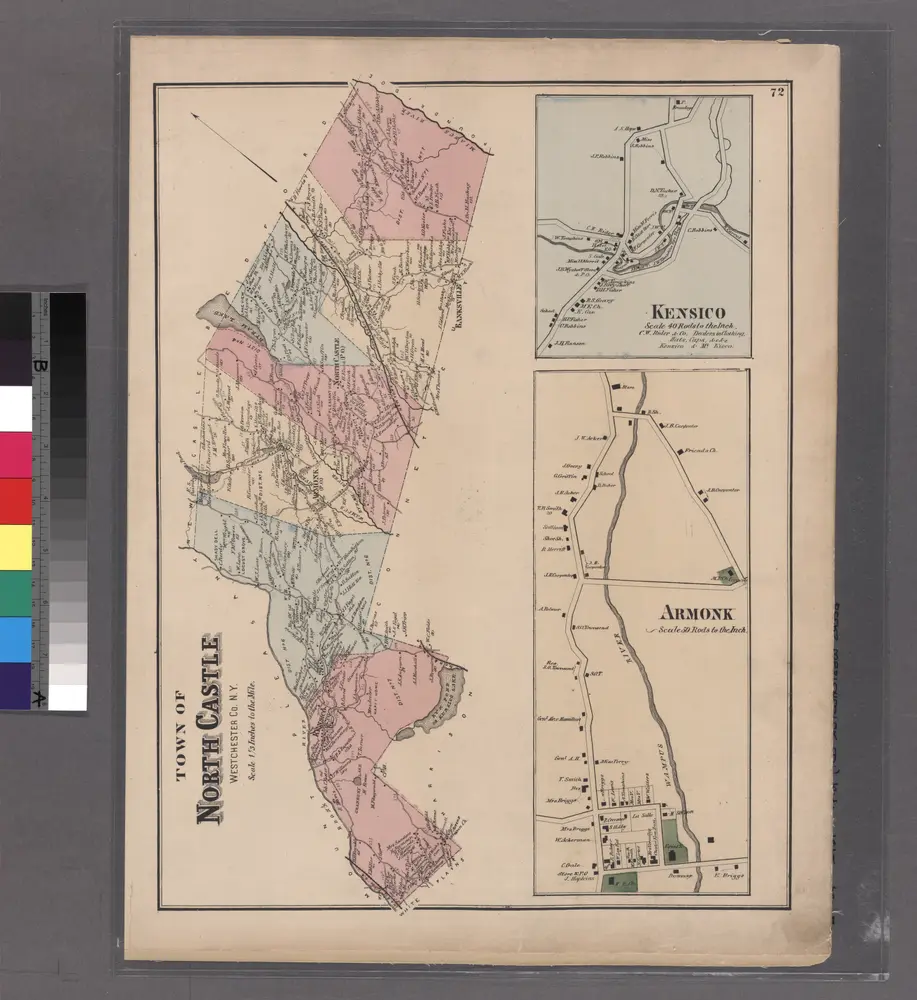
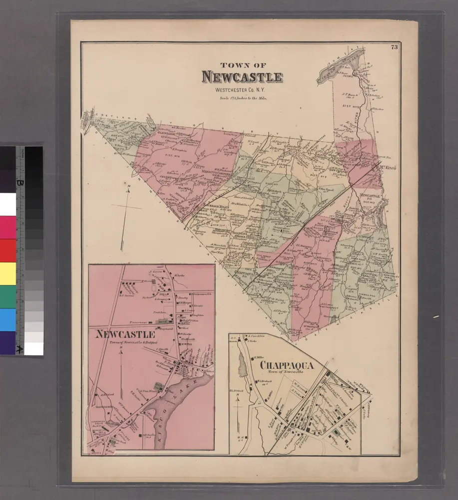
Maps of Town of New Castle

Maps of Town of New Castle

$title$

Westchester, Double Page Plate No. 24 [Map bounded by Underhill Rd., Hudson River] / prepared under the direction of Joseph R. Bien, from general surveys and official records.

From Atlas of Westchester County, New York
$title$

188-189 Ossining, Briar Cliff Manor.

1 : 18000 G.W. Bromley & Co.
$title$

Plate 52: Sinsing, Town of Ossining, Westchester Co.N.Y.

from Atlas of New York and vicinity : from actual surveys / by and under the direction of F. W. Beers, assisted by A. B. Prindle & others
$title$

Plates 45 & 46: Singsing, Town of Ossining, Westchester Co. N.Y.

from County atlas of Westchester, New York. Published by J.B. Beers & Co., assisted by S.W. Wilson and others.
$title$

186-187 Ossining.

1 : 5400 G.W. Bromley & Co.
$title$

Plates 45 & 46: Singsing, Town of Ossining, Westchester Co. N.Y.

from County atlas of Westchester, New York. Published by J.B. Beers & Co., assisted by S.W. Wilson and others.
$title$

176-177 Ossining.

1 : 5400 G.W. Bromley & Co.
$title$

184-185 Ossining.

1 : 5400 G.W. Bromley & Co.
$title$

Portion of Rockland County. ; Portion of Westchester County.

from Atlas of the Hudson River Valley from New York city to Troy, including a section of about 8 miles in width. Published by Watson & co. Compiled from official records and careful surveys, under the supervision of F. W. Beers.
$title$

Plan of Sing Sing and part of Town of Ossining.

from Atlas of the Hudson River Valley from New York city to Troy, including a section of about 8 miles in width. Published by Watson & co. Compiled from official records and careful surveys, under the supervision of F. W. Beers.
$title$

Ossining, Sparta.

1 : 25344 Beers, F. W. (Frederick W.)
$title$

154-155 Briarcliff Manor.

1 : 9600 G.W. Bromley & Co.
$title$

Croton Landing - Sparta.

from County atlas of Westchester, New York. Published by J.B. Beers & Co., assisted by S.W. Wilson and others.
$title$

7. Tarrytown-Oscawana-Merritt's Corners.

1 : 80000 Servoss, R. D.
$title$

7. Tarrytown-Oscawana-Merritt's Corners.

1 : 80000 Servoss, R. D.
$title$

Westchester Co., Scarborough-Putnam Co. line.

1 : 31680 Vermeule, C. C. (Cornelius Clarkson), 1858-1950
$title$

North part of Town of Mount Pleasant - Pleasantville.

from County atlas of Westchester, New York. Published by J.B. Beers & Co., assisted by S.W. Wilson and others.
$title$

12 Atlas rural country district north of New York City.

1 : 18000 Hyde, E. Belcher
$title$

Town of Newcastle, Westchester County, New York. (insets) Newcastle. Chappaqua.

1 : 39680 Beers, Frederick W.
$title$

New Castle town.

1 : 31680 Bien, Joseph Rudolf
$title$

Newcastle, Town.

1 : 39600 Beers, F. W. (Frederick W.)
$title$

Mt. Pleasant, Ossining towns.

1 : 25700 Bien, Joseph Rudolf
$title$

Mt. Pleasant, Town.

1 : 38016 Beers, F. W. (Frederick W.)
$title$

Ossining

1 : 24000
$title$

Ossining

1 : 24000
$title$

Ossining

1 : 24000
$title$

Ossining

1 : 24000
$title$

Ossining

1 : 24000
$title$

Ossining

1 : 24000
$title$

Ossining

1 : 31680
$title$

Ossining

1 : 25000
$title$

Ossining

1 : 31680
$title$

Ossining

1 : 31680
$title$

Ossining

1 : 24000
© MapTiler © OpenStreetMap contributors
How does it work?
These instructions will show you how to find historical maps online.
Getting started
Type the place name in the search box to find the exact location. You can further adjust the search by zooming in and out.
Zoom
Zoom in and out with the buttons or use your mouse or touchpad natively.
Exact Area tool
Click here and draw a rectangle over the map to precisely define the search area.
Set filters
Narrow your search with advanced settings, such as Years (from/to), Fulltext, Publisher, etc.
Results
See the results of your search on the right side. You can scroll down to find more maps of this location.
?

Download OldMapsOnline Mobile